Hodslavice elevation
Hodslavice (Moravskoslezský, Okres Nový Jičín), Czech Republic elevation is 339 meters and Hodslavice elevation in feet is 1112 ft above sea level [src 1]. Hodslavice is a populated place (feature code) with elevation that is 6 meters (20 ft) smaller than average city elevation in Czech Republic.
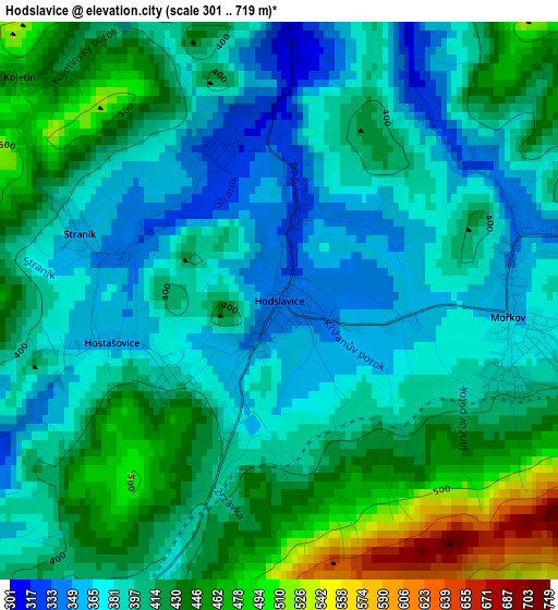
Below is the Elevation map of Hodslavice, which displays elevation range with different colors. Scale of the first map is from 301 to 719 m (988 to 2359 ft) with average elevation of 407.5 meters (=1337 ft) [note 1]
These maps also provides idea of topography and contour of this city, they are displayed at different zoom levels. More info about maps, scale and edge coordinates you can find below images.
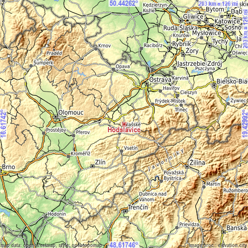
| \ | Map #1 | Topo.Map |
| Scale [m] | 301..719 m | × |
| Scale [ft] | 988..2359 ft | × |
| Average | 407.5 m = 1337 ft | × |
| Width | 6.34 km = 3.9 mi | 202.9 km = 126.1 mi |
| Height | 6.34 km = 3.9 mi | 202.9 km = 126.1 mi |
| ↑Max Latitude | 49.567069° | 50.44262° |
| Latitude at center | 49.53856° | 49.53856° |
| ↓Min Latitude | 49.510034° | 48.61746° |
| ← Min Longitude | 17.979725° | 16.61742° |
| Longitude center | 18.02367° | 18.02367° |
| →Max Longitude | 18.067615° | 19.42992° |
Nearby cities:
Cities around Hodslavice sort by population:
• Valašské Meziříčí elevation 311 m
8.3 km,  207°
207°
• Nový Jičín 287 m
6.3 km,  351°
351°
• Zubří 358 m
9.5 km,  148°
148°
• Štramberk 418 m
9 km,  48°
48°
• Vlčnov 342 m
6.7 km,  311°
311°
• Zašová 335 m
7.3 km,  168°
168°
• Mořkov 361 m
2.6 km,  94°
94°
• Starý Jičín 366 m
6.2 km, 313°
• Lešná 295 m
7 km,  253°
253°
• Veřovice 415 m
6.5 km, 89°
• Lichnov (o. Nový Jičín) 361 m
10.9 km,  74°
74°
• Rybí 318 m
7.9 km,  28°
28°
Multilingual:
 En español:
Hodslavice elevación 339 m.
 En France:
Hodslavice élévation 339 m.
 Auf Deutsch:
Hotzendorf höhe über dem Meeresspiegel ist 339 m.

Sources and notes:
- [note 1] Map square and city borders are not equal. Map elevation data is calculated only from area inside that square.
- [src 1] Elevation data from geonames database provided with same terms of usage.
- [src 2] The elevation map of Hodslavice is generated using elevation data from NASA's 3 arcsec (90m) resolution SRTM data.
- [src 3] Base (background) map © OpenStreetMap contributors tiles are generated by Geofabrik and OpenTopoMap.
Copyright & License:
This Hodslavice Elevation Map is licensed under CC BY-SA. You may reuse any part from this page, if you give a proper credit by linking to this URL:
 More info on terms of use page.