Potštát elevation
Potštát (Olomoucký, Okres Přerov), Czech Republic elevation is 498 meters and Potštát elevation in feet is 1634 ft above sea level [src 1]. Potštát is a populated place (feature code) with elevation that is 153 meters (502 ft) bigger than average city elevation in Czech Republic.
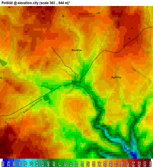
Below is the Elevation map of Potštát, which displays elevation range with different colors. Scale of the first map is from 363 to 644 m (1191 to 2113 ft) with average elevation of 550.2 meters (=1805 ft) [note 1]
These maps also provides idea of topography and contour of this city, they are displayed at different zoom levels. More info about maps, scale and edge coordinates you can find below images.
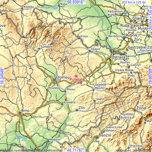
| \ | Map #1 | Topo.Map |
| Scale [m] | 363..644 m | × |
| Scale [ft] | 1191..2113 ft | × |
| Average | 550.2 m = 1805 ft | × |
| Width | 6.33 km = 3.9 mi | 202.5 km = 125.8 mi |
| Height | 6.33 km = 3.9 mi | 202.5 km = 125.8 mi |
| ↑Max Latitude | 49.665382° | 50.53916° |
| Latitude at center | 49.63693° | 49.63693° |
| ↓Min Latitude | 49.608461° | 48.71767° |
| ← Min Longitude | 17.607795° | 16.24549° |
| Longitude center | 17.65174° | 17.65174° |
| →Max Longitude | 17.695685° | 19.05799° |
Nearby cities:
Cities around Potštát sort by population:
• Hranice elevation 261 m
11.6 km,  148°
148°
• Lipník nad Bečvou 248 m
13.1 km,  201°
201°
• Odry 305 m
13.2 km,  77°
77°
• Vítkov 470 m
16.8 km,  24°
24°
• Budišov nad Budišovkou 510 m
17.7 km,  354°
354°
• Jeseník nad Odrou 258 m
18.5 km,  98°
98°
• Bělotín 294 m
12.3 km,  114°
114°
• Doloplazy 299 m
18.7 km,  246°
246°
• Město Libavá 544 m
13.4 km,  314°
314°
• Dolní Újezd 289 m
13.1 km,  219°
219°
• Osek nad Bečvou 225 m
16.6 km,  212°
212°
• Velký Újezd 372 m
13.8 km,  241°
241°
Multilingual:
 En español:
Potštát elevación 498 m.
 En France:
Potštát élévation 498 m.


Sources and notes:
- [note 1] Map square and city borders are not equal. Map elevation data is calculated only from area inside that square.
- [src 1] Elevation data from geonames database provided with same terms of usage.
- [src 2] The elevation map of Potštát is generated using elevation data from NASA's 3 arcsec (90m) resolution SRTM data.
- [src 3] Base (background) map © OpenStreetMap contributors tiles are generated by Geofabrik and OpenTopoMap.
Copyright & License:
This Potštát Elevation Map is licensed under CC BY-SA. You may reuse any part from this page, if you give a proper credit by linking to this URL:
 More info on terms of use page.