Tachov elevation
Tachov (Plzeňský kraj, Okres Tachov), Czech Republic elevation is 483 meters and Tachov elevation in feet is 1585 ft above sea level [src 1]. Tachov is a populated place (feature code) with elevation that is 138 meters (453 ft) bigger than average city elevation in Czech Republic.
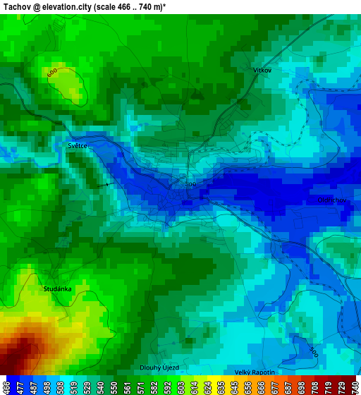
Below is the Elevation map of Tachov, which displays elevation range with different colors. Scale of the first map is from 466 to 740 m (1529 to 2428 ft) with average elevation of 541.3 meters (=1776 ft) [note 1]
These maps also provides idea of topography and contour of this city, they are displayed at different zoom levels. More info about maps, scale and edge coordinates you can find below images.
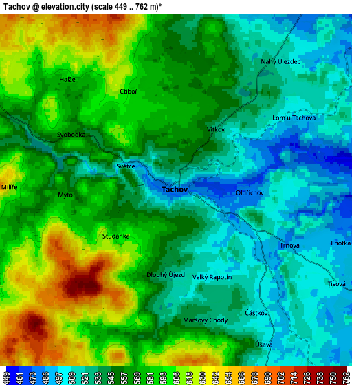
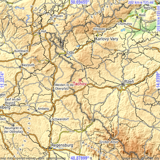
| \ | Map #1 | Map #2 | Topo.Map |
| Scale [m] | 466..740 m | 449..762 m | × |
| Scale [ft] | 1529..2428 ft | 1473..2500 ft | × |
| Average | 541.3 m = 1776 ft | 558.2 m = 1831 ft | × |
| Width | 6.31 km = 3.9 mi | 12.62 km = 7.8 mi | 201.9 km = 125.5 mi |
| Height | 6.31 km = 3.9 mi | 12.62 km = 7.8 mi | 201.9 km = 125.5 mi |
| ↑Max Latitude | 49.823639° | 49.851982° | 50.69455° |
| Latitude at center | 49.79528° | 49.79528° | 49.79528° |
| ↓Min Latitude | 49.766904° | 49.738512° | 48.87899° |
| ← Min Longitude | 12.589705° | 12.545759° | 11.2274° |
| Longitude center | 12.63365° | 12.63365° | 12.63365° |
| →Max Longitude | 12.677595° | 12.721541° | 14.0399° |
Nearby cities:
Cities around Tachov sort by population:
• Mariánské Lázně elevation 592 m
19.4 km,  14°
14°
• Planá 514 m
11.3 km,  44°
44°
• Bor 472 m
13.8 km,  132°
132°
• Klášter 660 m
25.9 km, 42°
• Velká Hleďsebe 558 m
18.6 km, 7°
• Bělá nad Radbuzou 441 m
23.5 km,  165°
165°
• Chodová Planá 525 m
12.9 km,  32°
32°
• Lázně Kynžvart 675 m
23.9 km,  358°
358°
• Přimda 696 m
13.7 km, 167°
• Dolní Žandov 537 m
25.5 km,  346°
346°
• Černošín 498 m
18.1 km,  82°
82°
• Stráž 453 m
17.4 km,  144°
144°
Multilingual:
 En español:
Tachov elevación 483 m.
 En France:
Tachov élévation 483 m.


Sources and notes:
- [note 1] Map square and city borders are not equal. Map elevation data is calculated only from area inside that square.
- [src 1] Elevation data from geonames database provided with same terms of usage.
- [src 2] The elevation map of Tachov is generated using elevation data from NASA's 3 arcsec (90m) resolution SRTM data.
- [src 3] Base (background) map © OpenStreetMap contributors tiles are generated by Geofabrik and OpenTopoMap.
Copyright & License:
This Tachov Elevation Map is licensed under CC BY-SA. You may reuse any part from this page, if you give a proper credit by linking to this URL:
 More info on terms of use page.