Velká Hleďsebe elevation
Velká Hleďsebe (Karlovarský kraj, Okres Cheb), Czech Republic elevation is 558 meters and Velká Hleďsebe elevation in feet is 1831 ft above sea level [src 1]. Velká Hleďsebe is a populated place (feature code) with elevation that is 213 meters (699 ft) bigger than average city elevation in Czech Republic.
Below is the Elevation map of Velká Hleďsebe, which displays elevation range with different colors. Scale of the first map is from 529 to 775 m (1736 to 2543 ft) with average elevation of 599.9 meters (=1968 ft) [note 1]
These maps also provides idea of topography and contour of this city, they are displayed at different zoom levels. More info about maps, scale and edge coordinates you can find below images.
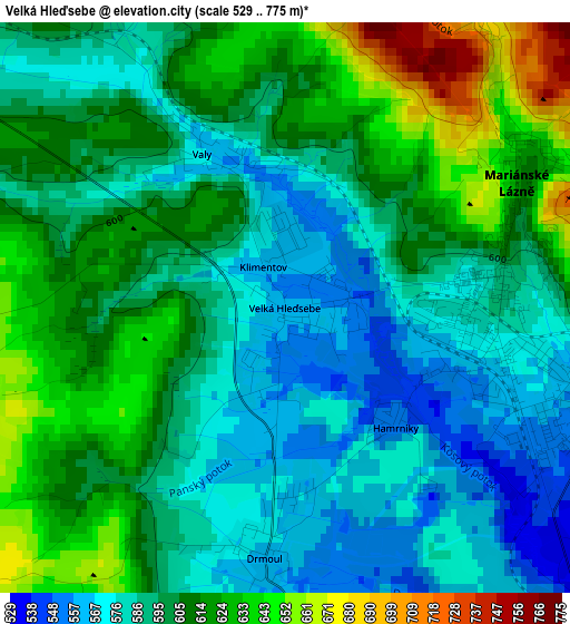
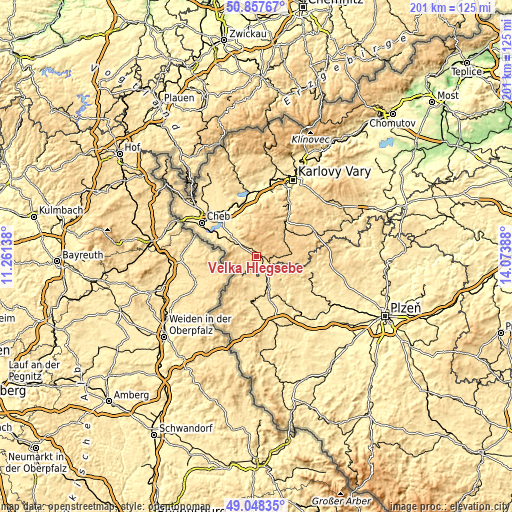
| \ | Map #1 | Topo.Map |
| Scale [m] | 529..775 m | × |
| Scale [ft] | 1736..2543 ft | × |
| Average | 599.9 m = 1968 ft | × |
| Width | 6.29 km = 3.9 mi | 201.2 km = 125 mi |
| Height | 6.29 km = 3.9 mi | 201.2 km = 125 mi |
| ↑Max Latitude | 49.989772° | 50.85767° |
| Latitude at center | 49.96151° | 49.96151° |
| ↓Min Latitude | 49.933232° | 49.04835° |
| ← Min Longitude | 12.623685° | 11.26138° |
| Longitude center | 12.66763° | 12.66763° |
| →Max Longitude | 12.711575° | 14.07388° |
Nearby cities:
Cities around Velká Hleďsebe sort by population:
• Mariánské Lázně elevation 592 m
2.4 km,  81°
81°
• Tachov 483 m
18.6 km,  187°
187°
• Horní Slavkov 567 m
22.1 km,  26°
26°
• Planá 514 m
11.7 km,  152°
152°
• Kynšperk nad Ohří 441 m
20.1 km,  330°
330°
• Klášter 660 m
14.9 km,  87°
87°
• Město 659 m
14.2 km, 81°
• Březová 509 m
20.5 km,  356°
356°
• Chodová Planá 525 m
8.8 km, 149°
• Lázně Kynžvart 675 m
6.3 km, 330°
• Dolní Žandov 537 m
10.4 km,  306°
306°
• Černošín 498 m
22.4 km,  136°
136°
Multilingual:
 En español:
Velká Hleďsebe elevación 558 m.
 En France:
Velká Hleďsebe élévation 558 m.
 Auf Deutsch:
Velká Hleďsebe höhe über dem Meeresspiegel ist 558 m.

Sources and notes:
- [note 1] Map square and city borders are not equal. Map elevation data is calculated only from area inside that square.
- [src 1] Elevation data from geonames database provided with same terms of usage.
- [src 2] The elevation map of Velká Hleďsebe is generated using elevation data from NASA's 3 arcsec (90m) resolution SRTM data.
- [src 3] Base (background) map © OpenStreetMap contributors tiles are generated by Geofabrik and OpenTopoMap.
Copyright & License:
This Velká Hleďsebe Elevation Map is licensed under CC BY-SA. You may reuse any part from this page, if you give a proper credit by linking to this URL:
 More info on terms of use page.