La Virgen elevation
La Virgen (Heredia, Sarapiquí), Costa Rica elevation is 188 meters and La Virgen elevation in feet is 617 ft above sea level [src 1]. La Virgen is a seat of a third-order administrative division (feature code) with elevation that is 552 meters (1811 ft) smaller than average city elevation in Costa Rica.
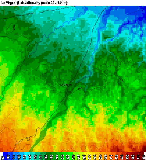
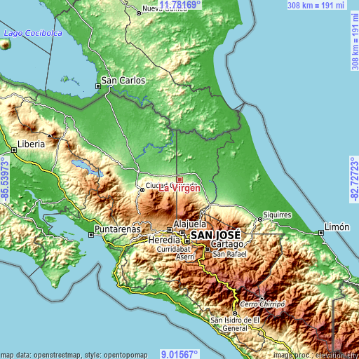
Below is the Elevation map of La Virgen, which displays elevation range with different colors. Scale of the first map is from 92 to 384 m (302 to 1260 ft) with average elevation of 211.7 meters (=695 ft) [note 1]
These maps also provides idea of topography and contour of this city, they are displayed at different zoom levels. More info about maps, scale and edge coordinates you can find below images.
| \ | Map #1 | Topo.Map |
| Scale [m] | 92..384 m | × |
| Scale [ft] | 302..1260 ft | × |
| Average | 211.7 m = 695 ft | × |
| Width | 9.61 km = 6 mi | 307.6 km = 191.1 mi |
| Height | 9.61 km = 6 mi | 307.6 km = 191.1 mi |
| ↑Max Latitude | 10.44496° | 11.78169° |
| Latitude at center | 10.40174° | 10.40174° |
| ↓Min Latitude | 10.358514° | 9.01567° |
| ← Min Longitude | -84.177425° | -85.53973° |
| Longitude center | -84.13348° | -84.13348° |
| →Max Longitude | -84.089535° | -82.72723° |
Nearby cities:
Cities around La Virgen sort by population:
• Quesada elevation 651 m
33.3 km,  254°
254°
• Guápiles 254 m
43.3 km,  118°
118°
• San Josecito 1272 m
43 km,  175°
175°
• Naranjo 1044 m
43 km,  218°
218°
• Río Segundo 1275 m
23.9 km, 221°
• San Juan 1090 m
38.9 km,  211°
211°
• Santo Domingo 1327 m
37.6 km, 183°
• Zarcero 1752 m
37 km,  229°
229°
• Pital 161 m
16.3 km,  289°
289°
• Sabanilla 1278 m
37.5 km,  193°
193°
• Sarchí 973 m
41.9 km, 214°
• Dulce Nombre de Jesus 634 m
32.6 km,  148°
148°
Multilingual:
 En español:
La Virgen elevación 188 m.
 En France:
La Virgen élévation 188 m.
 Auf Deutsch:
La Virgen höhe über dem Meeresspiegel ist 188 m.

Sources and notes:
- [note 1] Map square and city borders are not equal. Map elevation data is calculated only from area inside that square.
- [src 1] Elevation data from geonames database provided with same terms of usage.
- [src 2] The elevation map of La Virgen is generated using elevation data from NASA's 3 arcsec (90m) resolution SRTM data.
- [src 3] Base (background) map © OpenStreetMap contributors tiles are generated by Geofabrik and OpenTopoMap.
Copyright & License:
This La Virgen Elevation Map is licensed under CC BY-SA. You may reuse any part from this page, if you give a proper credit by linking to this URL:
 More info on terms of use page.