Naranjo elevation
Naranjo (Alajuela), Costa Rica elevation is 1044 meters and Naranjo elevation in feet is 3425 ft above sea level [src 1]. Naranjo is a populated place (feature code) with elevation that is 304 meters (997 ft) bigger than average city elevation in Costa Rica.
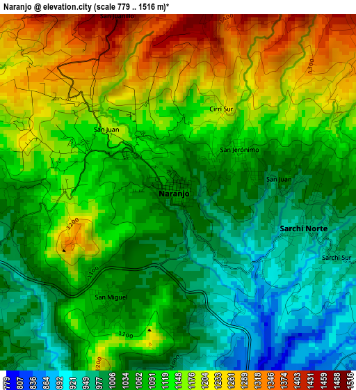
Below is the Elevation map of Naranjo, which displays elevation range with different colors. Scale of the first map is from 779 to 1516 m (2556 to 4974 ft) with average elevation of 1103.5 meters (=3620 ft) [note 1]
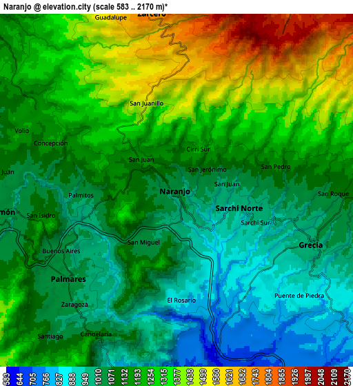
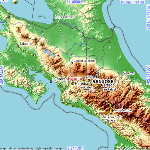
These maps also provides idea of topography and contour of this city, they are displayed at different zoom levels. More info about maps, scale and edge coordinates you can find below images.
| \ | Map #1 | Map #2 | Topo.Map |
| Scale [m] | 779..1516 m | 583..2170 m | × |
| Scale [ft] | 2556..4974 ft | 1913..7119 ft | × |
| Average | 1103.5 m = 3620 ft | 1168.1 m = 3832 ft | × |
| Width | 9.62 km = 6 mi | 19.24 km = 12 mi | 307.8 km = 191.3 mi |
| Height | 9.62 km = 6 mi | 19.24 km = 12 mi | 307.9 km = 191.3 mi |
| ↑Max Latitude | 10.141922° | 10.185177° | 11.48001° |
| Latitude at center | 10.09866° | 10.09866° | 10.09866° |
| ↓Min Latitude | 10.055393° | 10.012119° | 8.71135° |
| ← Min Longitude | -84.422185° | -84.466131° | -85.78449° |
| Longitude center | -84.37824° | -84.37824° | -84.37824° |
| →Max Longitude | -84.334295° | -84.290349° | -82.97199° |
Nearby cities:
Cities around Naranjo sort by population:
• San Ramón elevation 1061 m
10.1 km,  263°
263°
• Río Segundo 1275 m
19.2 km,  34°
34°
• San Juan 1090 m
6.7 km,  86°
86°
• Atenas 704 m
13.8 km,  180°
180°
• Carrillos 834 m
13.8 km,  124°
124°
• San Rafael 1074 m
11 km,  249°
249°
• Zarcero 1752 m
9.8 km,  351°
351°
• Santiago 1083 m
11.1 km,  220°
220°
• Esquipulas 1011 m
6.8 km,  226°
226°
• Sabanilla 1278 m
18 km,  98°
98°
• Barrio Jesús 884 m
14.6 km,  198°
198°
• Sarchí 973 m
3.5 km,  106°
106°
Multilingual:
 En español:
Naranjo elevación 1044 m.
 En France:
Naranjo élévation 1044 m.
 Auf Deutsch:
Naranjo höhe über dem Meeresspiegel ist 1044 m.

Sources and notes:
- [note 1] Map square and city borders are not equal. Map elevation data is calculated only from area inside that square.
- [src 1] Elevation data from geonames database provided with same terms of usage.
- [src 2] The elevation map of Naranjo is generated using elevation data from NASA's 3 arcsec (90m) resolution SRTM data.
- [src 3] Base (background) map © OpenStreetMap contributors tiles are generated by Geofabrik and OpenTopoMap.
Copyright & License:
This Naranjo Elevation Map is licensed under CC BY-SA. You may reuse any part from this page, if you give a proper credit by linking to this URL:
 More info on terms of use page.