Río Segundo elevation
Río Segundo (Alajuela, Valverde Vega), Costa Rica elevation is 1275 meters and Río Segundo elevation in feet is 4183 ft above sea level [src 1]. Río Segundo is a populated place (feature code) with elevation that is 535 meters (1755 ft) bigger than average city elevation in Costa Rica.
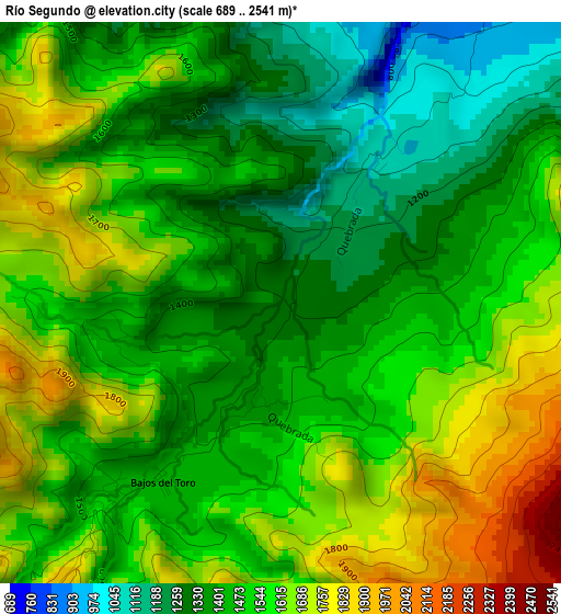
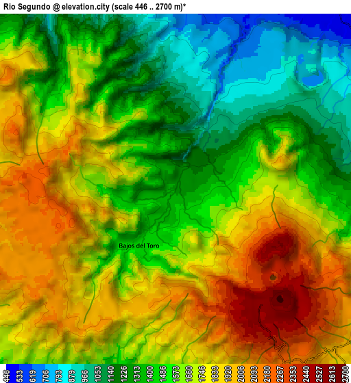
Below is the Elevation map of Río Segundo, which displays elevation range with different colors. Scale of the first map is from 689 to 2541 m (2260 to 8337 ft) with average elevation of 1512.6 meters (=4963 ft) [note 1]
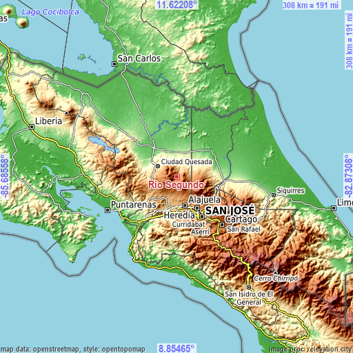
These maps also provides idea of topography and contour of this city, they are displayed at different zoom levels. More info about maps, scale and edge coordinates you can find below images.
| \ | Map #1 | Map #2 | Topo.Map |
| Scale [m] | 689..2541 m | 446..2700 m | × |
| Scale [ft] | 2260..8337 ft | 1463..8858 ft | × |
| Average | 1512.6 m = 4963 ft | 1607.7 m = 5275 ft | × |
| Width | 9.62 km = 6 mi | 19.23 km = 11.9 mi | 307.7 km = 191.2 mi |
| Height | 9.62 km = 6 mi | 19.23 km = 11.9 mi | 307.7 km = 191.2 mi |
| ↑Max Latitude | 10.284622° | 10.327858° | 11.62208° |
| Latitude at center | 10.24138° | 10.24138° | 10.24138° |
| ↓Min Latitude | 10.198132° | 10.154878° | 8.85465° |
| ← Min Longitude | -84.323275° | -84.367221° | -85.68558° |
| Longitude center | -84.27933° | -84.27933° | -84.27933° |
| →Max Longitude | -84.235385° | -84.191439° | -82.87308° |
Nearby cities:
Cities around Río Segundo sort by population:
• Alajuela elevation 954 m
26.1 km,  163°
163°
• Quesada 651 m
18.6 km,  299°
299°
• Naranjo 1044 m
19.2 km,  214°
214°
• San Juan 1090 m
16 km,  194°
194°
• Santo Domingo 1327 m
24 km,  145°
145°
• Carrillos 834 m
23.6 km,  178°
178°
• Zarcero 1752 m
13.7 km,  243°
243°
• Pital 161 m
23.3 km,  1°
1°
• Esquipulas 1011 m
25.9 km,  217°
217°
• Sabanilla 1278 m
19.9 km, 159°
• La Virgen 188 m
23.9 km,  41°
41°
• Sarchí 973 m
18.4 km,  203°
203°
Multilingual:
 En español:
Río Segundo elevación 1275 m.
 En France:
Río Segundo élévation 1275 m.
 Auf Deutsch:
Río Segundo höhe über dem Meeresspiegel ist 1275 m.

Sources and notes:
- [note 1] Map square and city borders are not equal. Map elevation data is calculated only from area inside that square.
- [src 1] Elevation data from geonames database provided with same terms of usage.
- [src 2] The elevation map of Río Segundo is generated using elevation data from NASA's 3 arcsec (90m) resolution SRTM data.
- [src 3] Base (background) map © OpenStreetMap contributors tiles are generated by Geofabrik and OpenTopoMap.
Copyright & License:
This Río Segundo Elevation Map is licensed under CC BY-SA. You may reuse any part from this page, if you give a proper credit by linking to this URL:
 More info on terms of use page.