Parrita elevation
Parrita (Puntarenas), Costa Rica elevation is 12 meters and Parrita elevation in feet is 39 ft above sea level [src 1]. Parrita is a populated place (feature code) with elevation that is 728 meters (2388 ft) smaller than average city elevation in Costa Rica.
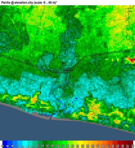
Below is the Elevation map of Parrita, which displays elevation range with different colors. Scale of the first map is from -9 to 60 m (-30 to 197 ft) with average elevation of 16.3 meters (=53 ft) [note 1]
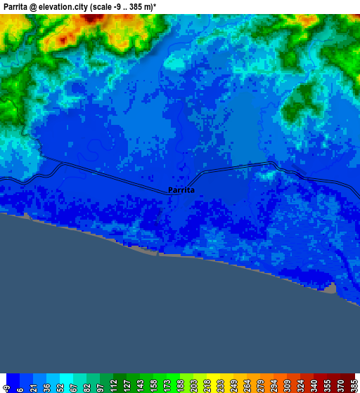
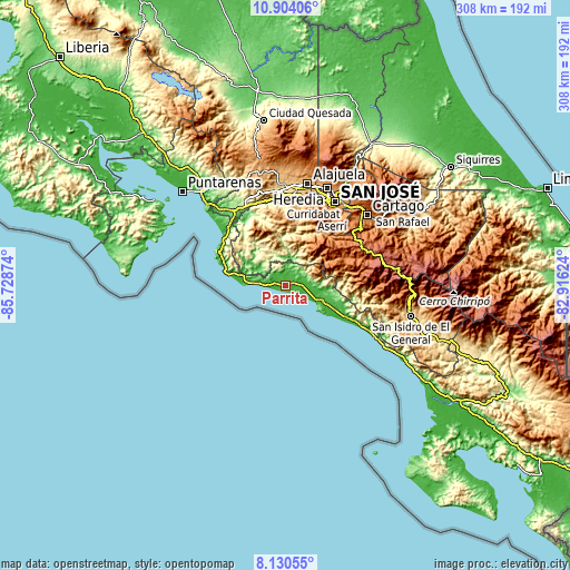
These maps also provides idea of topography and contour of this city, they are displayed at different zoom levels. More info about maps, scale and edge coordinates you can find below images.
| \ | Map #1 | Map #2 | Topo.Map |
| Scale [m] | -9..60 m | -9..385 m | × |
| Scale [ft] | -30..197 ft | -30..1263 ft | × |
| Average | 16.3 m = 53 ft | 47.2 m = 155 ft | × |
| Width | 9.64 km = 6 mi | 19.28 km = 12 mi | 308.4 km = 191.6 mi |
| Height | 9.64 km = 6 mi | 19.28 km = 12 mi | 308.4 km = 191.6 mi |
| ↑Max Latitude | 9.563457° | 9.606789° | 10.90406° |
| Latitude at center | 9.52012° | 9.52012° | 9.52012° |
| ↓Min Latitude | 9.476777° | 9.433429° | 8.13055° |
| ← Min Longitude | -84.366435° | -84.410381° | -85.72874° |
| Longitude center | -84.32249° | -84.32249° | -84.32249° |
| →Max Longitude | -84.278545° | -84.234599° | -82.91624° |
Nearby cities:
Cities around Parrita sort by population:
• San Rafael Abajo elevation 826 m
34.7 km,  5°
5°
• Tejar 989 m
27 km,  21°
21°
• Colón 801 m
44.8 km, 11°
• Santiago 1109 m
36.3 km,  1°
1°
• Quepos 7 m
20.2 km,  119°
119°
• San Marcos 1435 m
36.6 km,  64°
64°
• Jacó 10 m
35.3 km,  287°
287°
• San Ignacio 1097 m
35.6 km,  29°
29°
• Pacayas 1675 m
43.9 km,  43°
43°
• Palmichal 1098 m
37.6 km, 20°
• San Pablo 1535 m
35.8 km, 59°
• Monterrey 987 m
35.2 km, 41°
Multilingual:
 En español:
Parrita elevación 12 m.
 En France:
Parrita élévation 12 m.


Sources and notes:
- [note 1] Map square and city borders are not equal. Map elevation data is calculated only from area inside that square.
- [src 1] Elevation data from geonames database provided with same terms of usage.
- [src 2] The elevation map of Parrita is generated using elevation data from NASA's 3 arcsec (90m) resolution SRTM data.
- [src 3] Base (background) map © OpenStreetMap contributors tiles are generated by Geofabrik and OpenTopoMap.
Copyright & License:
This Parrita Elevation Map is licensed under CC BY-SA. You may reuse any part from this page, if you give a proper credit by linking to this URL:
 More info on terms of use page.