San Marcos elevation
San Marcos (San José, Tarrazú), Costa Rica elevation is 1435 meters and San Marcos elevation in feet is 4708 ft above sea level [src 1]. San Marcos is a seat of a second-order administrative division (feature code) with elevation that is 695 meters (2280 ft) bigger than average city elevation in Costa Rica.
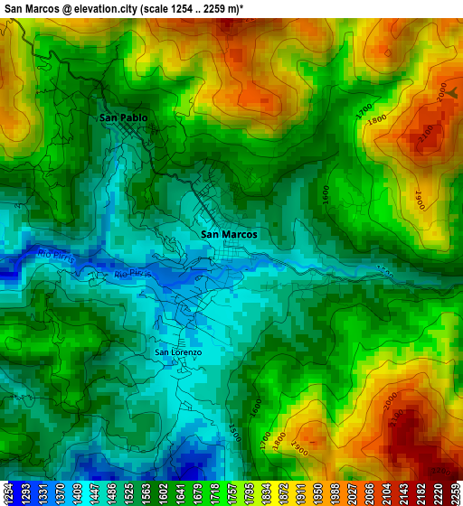
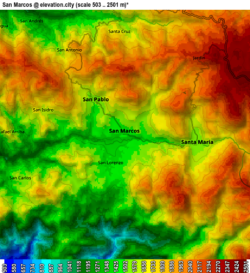
Below is the Elevation map of San Marcos, which displays elevation range with different colors. Scale of the first map is from 1254 to 2259 m (4114 to 7411 ft) with average elevation of 1663.1 meters (=5456 ft) [note 1]
These maps also provides idea of topography and contour of this city, they are displayed at different zoom levels. More info about maps, scale and edge coordinates you can find below images.
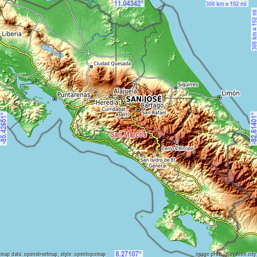
| \ | Map #1 | Map #2 | Topo.Map |
| Scale [m] | 1254..2259 m | 503..2501 m | × |
| Scale [ft] | 4114..7411 ft | 1650..8205 ft | × |
| Average | 1663.1 m = 5456 ft | 1676.7 m = 5501 ft | × |
| Width | 9.63 km = 6 mi | 19.27 km = 12 mi | 308.3 km = 191.6 mi |
| Height | 9.63 km = 6 mi | 19.27 km = 12 mi | 308.3 km = 191.6 mi |
| ↑Max Latitude | 9.703419° | 9.746733° | 11.04342° |
| Latitude at center | 9.6601° | 9.6601° | 9.6601° |
| ↓Min Latitude | 9.616775° | 9.573444° | 8.27107° |
| ← Min Longitude | -84.064205° | -84.108151° | -85.42651° |
| Longitude center | -84.02026° | -84.02026° | -84.02026° |
| →Max Longitude | -83.976315° | -83.932369° | -82.61401° |
Nearby cities:
Cities around San Marcos sort by population:
• San Miguel elevation 1216 m
23.9 km,  349°
349°
• Aserrí 1331 m
23.5 km,  340°
340°
• Patarrá 1180 m
24.6 km,  356°
356°
• San Juan de Dios 1207 m
25.2 km, 343°
• San Rafael Arriba 1205 m
24.7 km, 345°
• Salitrillos 1319 m
22.7 km, 340°
• Orosí 1058 m
23.7 km,  50°
50°
• Tobosi 1409 m
20.2 km,  11°
11°
• San Ignacio 1097 m
21.8 km,  314°
314°
• Pacayas 1675 m
16.6 km, 349°
• Monterrey 987 m
14.6 km,  317°
317°
• San Pablo 1535 m
3.4 km, 319°
Multilingual:
 En español:
San Marcos elevación 1435 m.
 En France:
San Marcos élévation 1435 m.
 Auf Deutsch:
San Marcos höhe über dem Meeresspiegel ist 1435 m.

Sources and notes:
- [note 1] Map square and city borders are not equal. Map elevation data is calculated only from area inside that square.
- [src 1] Elevation data from geonames database provided with same terms of usage.
- [src 2] The elevation map of San Marcos is generated using elevation data from NASA's 3 arcsec (90m) resolution SRTM data.
- [src 3] Base (background) map © OpenStreetMap contributors tiles are generated by Geofabrik and OpenTopoMap.
Copyright & License:
This San Marcos Elevation Map is licensed under CC BY-SA. You may reuse any part from this page, if you give a proper credit by linking to this URL:
 More info on terms of use page.