Orosí elevation
Orosí (Cartago, Paraíso), Costa Rica elevation is 1058 meters and Orosí elevation in feet is 3471 ft above sea level [src 1]. Orosí is a populated place (feature code) with elevation that is 318 meters (1043 ft) bigger than average city elevation in Costa Rica.
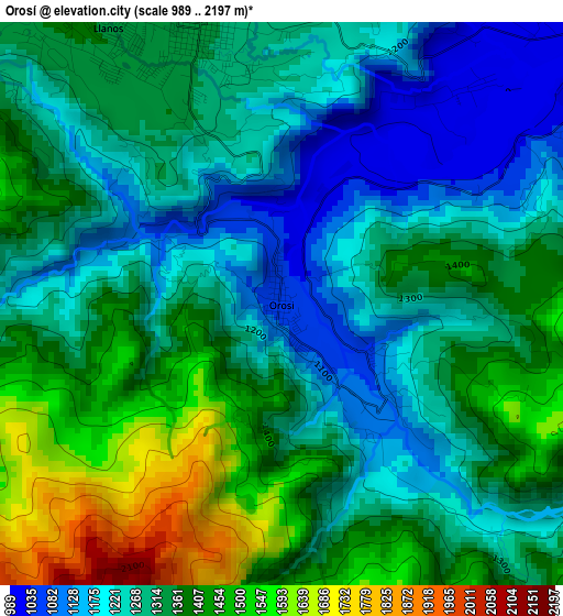
Below is the Elevation map of Orosí, which displays elevation range with different colors. Scale of the first map is from 989 to 2197 m (3245 to 7208 ft) with average elevation of 1324.6 meters (=4346 ft) [note 1]
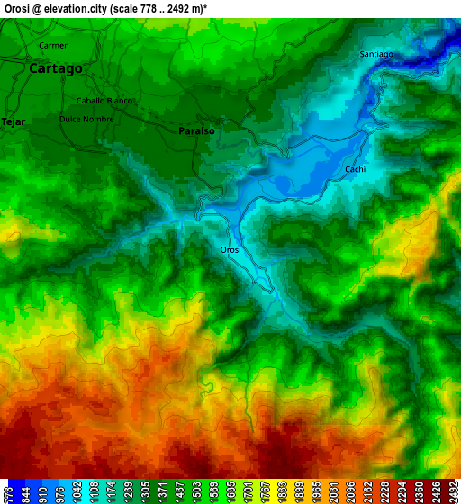
These maps also provides idea of topography and contour of this city, they are displayed at different zoom levels. More info about maps, scale and edge coordinates you can find below images.
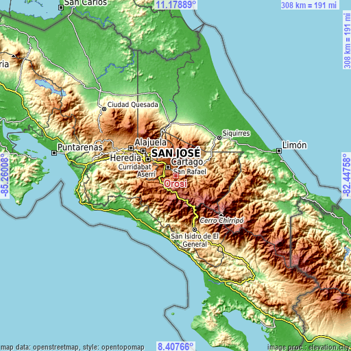
| \ | Map #1 | Map #2 | Topo.Map |
| Scale [m] | 989..2197 m | 778..2492 m | × |
| Scale [ft] | 3245..7208 ft | 2552..8176 ft | × |
| Average | 1324.6 m = 4346 ft | 1537.4 m = 5044 ft | × |
| Width | 9.63 km = 6 mi | 19.26 km = 12 mi | 308.1 km = 191.4 mi |
| Height | 9.63 km = 6 mi | 19.26 km = 12 mi | 308.2 km = 191.5 mi |
| ↑Max Latitude | 9.839472° | 9.882768° | 11.17889° |
| Latitude at center | 9.79617° | 9.79617° | 9.79617° |
| ↓Min Latitude | 9.752863° | 9.70955° | 8.40766° |
| ← Min Longitude | -83.897775° | -83.941721° | -85.26008° |
| Longitude center | -83.85383° | -83.85383° | -83.85383° |
| →Max Longitude | -83.809885° | -83.765939° | -82.44758° |
Nearby cities:
Cities around Orosí sort by population:
• Paraíso elevation 1332 m
4.9 km,  344°
344°
• Turrialba 648 m
22.2 km,  57°
57°
• Cartago 1440 m
10.5 km,  316°
316°
• Patarrá 1180 m
22 km,  295°
295°
• San Diego 1275 m
19.9 km, 304°
• Concepción 1388 m
22.1 km,  313°
313°
• Tres Ríos 1332 m
19.1 km, 309°
• Cot 1811 m
11.1 km,  349°
349°
• Tobosi 1409 m
15 km,  288°
288°
• Tucurrique 779 m
15.7 km,  66°
66°
• Pejibaye 652 m
16.6 km,  84°
84°
• Pacayas 1675 m
21.3 km,  273°
273°
Multilingual:
 En español:
Orosí elevación 1058 m.
 En France:
Orosí élévation 1058 m.


Sources and notes:
- [note 1] Map square and city borders are not equal. Map elevation data is calculated only from area inside that square.
- [src 1] Elevation data from geonames database provided with same terms of usage.
- [src 2] The elevation map of Orosí is generated using elevation data from NASA's 3 arcsec (90m) resolution SRTM data.
- [src 3] Base (background) map © OpenStreetMap contributors tiles are generated by Geofabrik and OpenTopoMap.
Copyright & License:
This Orosí Elevation Map is licensed under CC BY-SA. You may reuse any part from this page, if you give a proper credit by linking to this URL:
 More info on terms of use page.