Salitrillos elevation
Salitrillos (San José, Aserrí), Costa Rica elevation is 1319 meters and Salitrillos elevation in feet is 4327 ft above sea level [src 1]. Salitrillos is a populated place (feature code) with elevation that is 579 meters (1900 ft) bigger than average city elevation in Costa Rica.
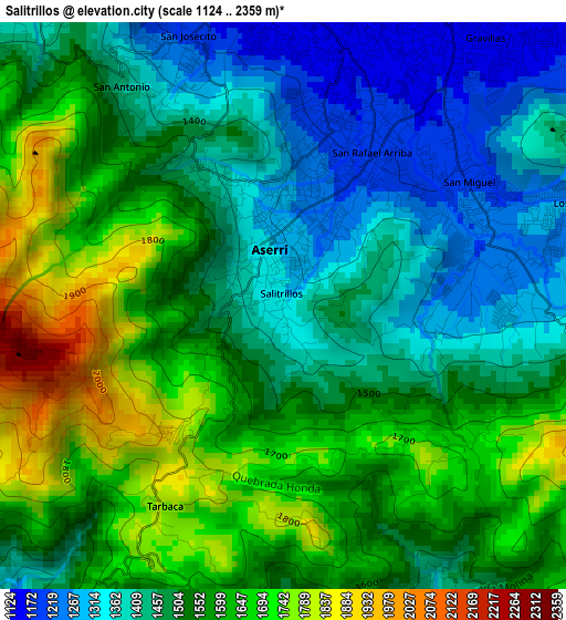
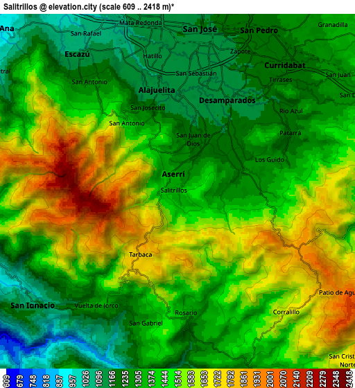
Below is the Elevation map of Salitrillos, which displays elevation range with different colors. Scale of the first map is from 1124 to 2359 m (3688 to 7740 ft) with average elevation of 1523.7 meters (=4999 ft) [note 1]
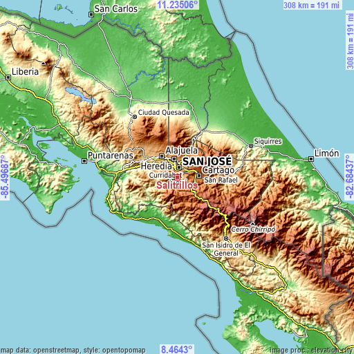
These maps also provides idea of topography and contour of this city, they are displayed at different zoom levels. More info about maps, scale and edge coordinates you can find below images.
| \ | Map #1 | Map #2 | Topo.Map |
| Scale [m] | 1124..2359 m | 609..2418 m | × |
| Scale [ft] | 3688..7740 ft | 1998..7933 ft | × |
| Average | 1523.7 m = 4999 ft | 1421.5 m = 4664 ft | × |
| Width | 9.63 km = 6 mi | 19.26 km = 12 mi | 308.1 km = 191.4 mi |
| Height | 9.63 km = 6 mi | 19.26 km = 12 mi | 308.1 km = 191.4 mi |
| ↑Max Latitude | 9.895884° | 9.939173° | 11.23506° |
| Latitude at center | 9.85259° | 9.85259° | 9.85259° |
| ↓Min Latitude | 9.80929° | 9.765984° | 8.4643° |
| ← Min Longitude | -84.134565° | -84.178511° | -85.49687° |
| Longitude center | -84.09062° | -84.09062° | -84.09062° |
| →Max Longitude | -84.046675° | -84.002729° | -82.68437° |
Nearby cities:
Cities around Salitrillos sort by population:
• San José elevation 1161 m
9 km,  5°
5°
• Curridabat 1212 m
9 km,  43°
43°
• San Miguel 1216 m
3.9 km,  57°
57°
• San Pedro 1199 m
9.5 km,  27°
27°
• Aserrí 1331 m
0.7 km,  344°
344°
• San Felipe 1127 m
6 km, 344°
• Patarrá 1180 m
6.8 km, 62°
• San Juan de Dios 1207 m
2.8 km, 13°
• San Rafael Arriba 1205 m
3 km, 31°
• Alajuelita 1135 m
5.6 km,  348°
348°
• Escazú 1111 m
9.1 km,  323°
323°
• Pacayas 1675 m
6.9 km,  137°
137°
Multilingual:
 En español:
Salitrillos elevación 1319 m.
 En France:
Salitrillos élévation 1319 m.
 Auf Deutsch:
Salitrillos höhe über dem Meeresspiegel ist 1319 m.

Sources and notes:
- [note 1] Map square and city borders are not equal. Map elevation data is calculated only from area inside that square.
- [src 1] Elevation data from geonames database provided with same terms of usage.
- [src 2] The elevation map of Salitrillos is generated using elevation data from NASA's 3 arcsec (90m) resolution SRTM data.
- [src 3] Base (background) map © OpenStreetMap contributors tiles are generated by Geofabrik and OpenTopoMap.
Copyright & License:
This Salitrillos Elevation Map is licensed under CC BY-SA. You may reuse any part from this page, if you give a proper credit by linking to this URL:
 More info on terms of use page.