Curridabat elevation
Curridabat (San José), Costa Rica elevation is 1212 meters and Curridabat elevation in feet is 3976 ft above sea level [src 1]. Curridabat is a populated place (feature code) with elevation that is 472 meters (1549 ft) bigger than average city elevation in Costa Rica.
Below is the Elevation map of Curridabat, which displays elevation range with different colors. Scale of the first map is from 1124 to 1675 m (3688 to 5495 ft) with average elevation of 1259.8 meters (=4133 ft) [note 1]
These maps also provides idea of topography and contour of this city, they are displayed at different zoom levels. More info about maps, scale and edge coordinates you can find below images.
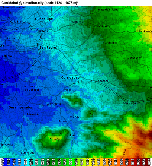
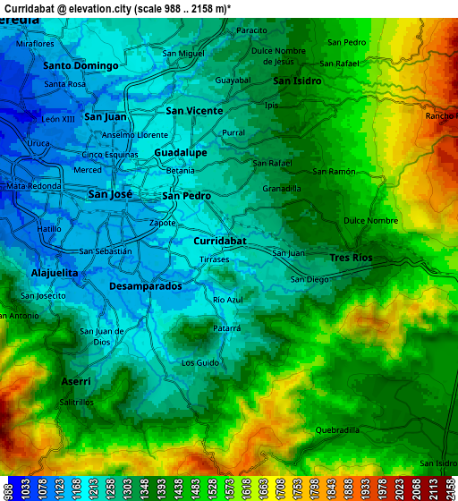
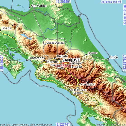
| \ | Map #1 | Map #2 | Topo.Map |
| Scale [m] | 1124..1675 m | 988..2158 m | × |
| Scale [ft] | 3688..5495 ft | 3241..7080 ft | × |
| Average | 1259.8 m = 4133 ft | 1384.9 m = 4544 ft | × |
| Width | 9.63 km = 6 mi | 19.25 km = 12 mi | 308 km = 191.4 mi |
| Height | 9.63 km = 6 mi | 19.25 km = 12 mi | 308.1 km = 191.4 mi |
| ↑Max Latitude | 9.955077° | 9.998357° | 11.29399° |
| Latitude at center | 9.91179° | 9.91179° | 9.91179° |
| ↓Min Latitude | 9.868498° | 9.8252° | 8.52374° |
| ← Min Longitude | -84.078015° | -84.121961° | -85.44032° |
| Longitude center | -84.03407° | -84.03407° | -84.03407° |
| →Max Longitude | -83.990125° | -83.946179° | -82.62782° |
Nearby cities:
Cities around Curridabat sort by population:
• San Vicente elevation 1236 m
5.6 km,  344°
344°
• Purral 1270 m
5.2 km,  4°
4°
• San Miguel 1216 m
5.4 km,  213°
213°
• San Pedro 1199 m
2.6 km,  315°
315°
• Guadalupe 1202 m
4.7 km,  328°
328°
• Patarrá 1180 m
3.5 km,  181°
181°
• Calle Blancos 1188 m
5.5 km, 319°
• San Diego 1275 m
3.7 km,  112°
112°
• Concepción 1388 m
4.4 km,  57°
57°
• Sabanilla 1240 m
3.8 km,  351°
351°
• Granadilla 1326 m
3.2 km,  36°
36°
• Tres Ríos 1332 m
5.1 km,  96°
96°
Multilingual:
 En español:
Curridabat elevación 1212 m.
 En France:
Curridabat élévation 1212 m.
 Auf Deutsch:
Curridabat höhe über dem Meeresspiegel ist 1212 m.

Sources and notes:
- [note 1] Map square and city borders are not equal. Map elevation data is calculated only from area inside that square.
- [src 1] Elevation data from geonames database provided with same terms of usage.
- [src 2] The elevation map of Curridabat is generated using elevation data from NASA's 3 arcsec (90m) resolution SRTM data.
- [src 3] Base (background) map © OpenStreetMap contributors tiles are generated by Geofabrik and OpenTopoMap.
Copyright & License:
This Curridabat Elevation Map is licensed under CC BY-SA. You may reuse any part from this page, if you give a proper credit by linking to this URL:
 More info on terms of use page.