Purral elevation
Purral (San José, Goicoechea), Costa Rica elevation is 1270 meters and Purral elevation in feet is 4167 ft above sea level [src 1]. Purral is a populated place (feature code) with elevation that is 530 meters (1739 ft) bigger than average city elevation in Costa Rica.
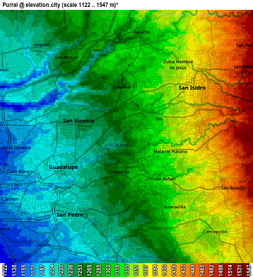
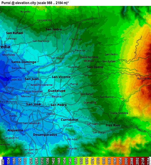
Below is the Elevation map of Purral, which displays elevation range with different colors. Scale of the first map is from 1122 to 1547 m (3681 to 5075 ft) with average elevation of 1294.1 meters (=4246 ft) [note 1]
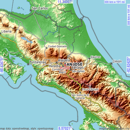
These maps also provides idea of topography and contour of this city, they are displayed at different zoom levels. More info about maps, scale and edge coordinates you can find below images.
| \ | Map #1 | Map #2 | Topo.Map |
| Scale [m] | 1122..1547 m | 988..2184 m | × |
| Scale [ft] | 3681..5075 ft | 3241..7165 ft | × |
| Average | 1294.1 m = 4246 ft | 1373.4 m = 4506 ft | × |
| Width | 9.63 km = 6 mi | 19.25 km = 12 mi | 308 km = 191.4 mi |
| Height | 9.63 km = 6 mi | 19.25 km = 12 mi | 308 km = 191.4 mi |
| ↑Max Latitude | 10.00136° | 10.044635° | 11.34007° |
| Latitude at center | 9.95808° | 9.95808° | 9.95808° |
| ↓Min Latitude | 9.914794° | 9.871502° | 8.57021° |
| ← Min Longitude | -84.074445° | -84.118391° | -85.43675° |
| Longitude center | -84.0305° | -84.0305° | -84.0305° |
| →Max Longitude | -83.986555° | -83.942609° | -82.62425° |
Nearby cities:
Cities around Purral sort by population:
• Curridabat elevation 1212 m
5.2 km,  184°
184°
• San Vicente de Moravia 1235 m
2 km,  281°
281°
• San Vicente 1236 m
1.9 km, 277°
• San Pedro 1199 m
4 km,  213°
213°
• Ipís 1352 m
2.2 km,  61°
61°
• San Juan 1151 m
5.6 km,  271°
271°
• Guadalupe 1202 m
3.1 km,  248°
248°
• Calle Blancos 1188 m
4.1 km,  257°
257°
• Concepción 1388 m
4.3 km,  129°
129°
• Sabanilla 1240 m
1.7 km, 213°
• Granadilla 1326 m
3 km,  149°
149°
• Ángeles 1272 m
4.8 km,  331°
331°
Multilingual:
 En español:
Purral elevación 1270 m.
 En France:
Purral élévation 1270 m.


Sources and notes:
- [note 1] Map square and city borders are not equal. Map elevation data is calculated only from area inside that square.
- [src 1] Elevation data from geonames database provided with same terms of usage.
- [src 2] The elevation map of Purral is generated using elevation data from NASA's 3 arcsec (90m) resolution SRTM data.
- [src 3] Base (background) map © OpenStreetMap contributors tiles are generated by Geofabrik and OpenTopoMap.
Copyright & License:
This Purral Elevation Map is licensed under CC BY-SA. You may reuse any part from this page, if you give a proper credit by linking to this URL:
 More info on terms of use page.