San Rafael Abajo elevation
San Rafael Abajo (San José, Puriscal), Costa Rica elevation is 826 meters and San Rafael Abajo elevation in feet is 2710 ft above sea level [src 1]. San Rafael Abajo is a populated place (feature code) with elevation that is 86 meters (282 ft) bigger than average city elevation in Costa Rica.
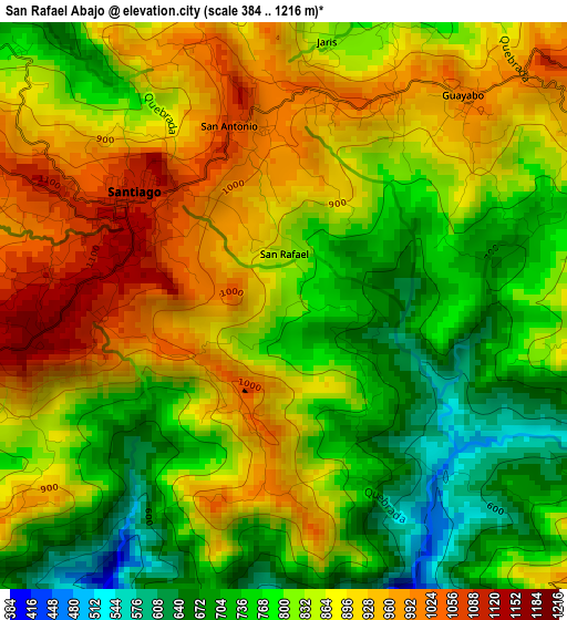
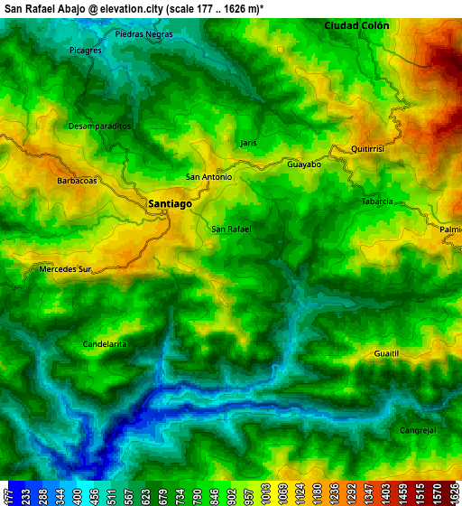
Below is the Elevation map of San Rafael Abajo, which displays elevation range with different colors. Scale of the first map is from 384 to 1216 m (1260 to 3990 ft) with average elevation of 839.8 meters (=2755 ft) [note 1]
These maps also provides idea of topography and contour of this city, they are displayed at different zoom levels. More info about maps, scale and edge coordinates you can find below images.
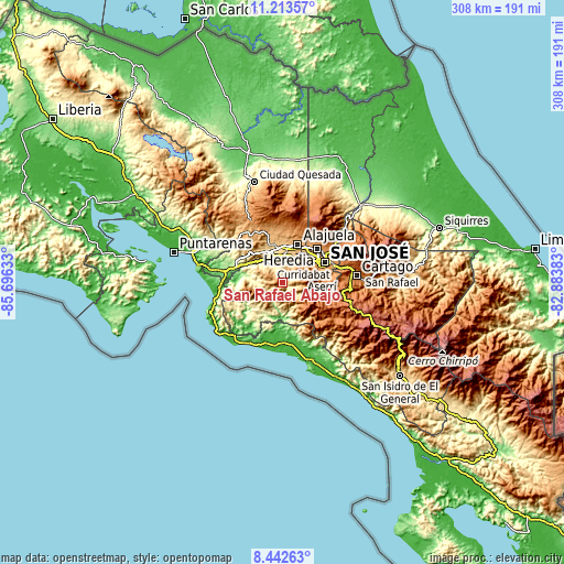
| \ | Map #1 | Map #2 | Topo.Map |
| Scale [m] | 384..1216 m | 177..1626 m | × |
| Scale [ft] | 1260..3990 ft | 581..5335 ft | × |
| Average | 839.8 m = 2755 ft | 800.4 m = 2626 ft | × |
| Width | 9.63 km = 6 mi | 19.26 km = 12 mi | 308.1 km = 191.4 mi |
| Height | 9.63 km = 6 mi | 19.26 km = 12 mi | 308.1 km = 191.4 mi |
| ↑Max Latitude | 9.874297° | 9.917589° | 11.21357° |
| Latitude at center | 9.831° | 9.831° | 9.831° |
| ↓Min Latitude | 9.787697° | 9.744389° | 8.44263° |
| ← Min Longitude | -84.334025° | -84.377971° | -85.69633° |
| Longitude center | -84.29008° | -84.29008° | -84.29008° |
| →Max Longitude | -84.246135° | -84.202189° | -82.88383° |
Nearby cities:
Cities around San Rafael Abajo sort by population:
• San Rafael elevation 1060 m
19.9 km,  57°
57°
• Tejar 989 m
11.3 km,  146°
146°
• Escazú 1111 m
19.1 km, 59°
• San Antonio 937 m
20.6 km,  34°
34°
• Colón 801 m
10.7 km, 29°
• Santiago 1109 m
3.2 km,  302°
302°
• Santa Ana 909 m
16.3 km,  46°
46°
• Atenas 704 m
18.7 km,  328°
328°
• La Asunción 956 m
20.9 km,  37°
37°
• San Ignacio 1097 m
14.5 km,  104°
104°
• Salitral 1038 m
15.2 km, 53°
• Palmichal 1098 m
9.4 km,  85°
85°
Multilingual:
 En español:
San Rafael Abajo elevación 826 m.
 En France:
San Rafael Abajo élévation 826 m.
 Auf Deutsch:
San Rafael Abajo höhe über dem Meeresspiegel ist 826 m.

Sources and notes:
- [note 1] Map square and city borders are not equal. Map elevation data is calculated only from area inside that square.
- [src 1] Elevation data from geonames database provided with same terms of usage.
- [src 2] The elevation map of San Rafael Abajo is generated using elevation data from NASA's 3 arcsec (90m) resolution SRTM data.
- [src 3] Base (background) map © OpenStreetMap contributors tiles are generated by Geofabrik and OpenTopoMap.
Copyright & License:
This San Rafael Abajo Elevation Map is licensed under CC BY-SA. You may reuse any part from this page, if you give a proper credit by linking to this URL:
 More info on terms of use page.