Colón elevation
Colón (San José, Mora), Costa Rica elevation is 801 meters and Colón elevation in feet is 2628 ft above sea level [src 1]. Colón is a populated place (feature code) with elevation that is 61 meters (200 ft) bigger than average city elevation in Costa Rica.
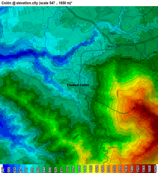
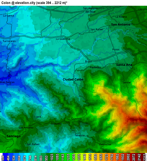
Below is the Elevation map of Colón, which displays elevation range with different colors. Scale of the first map is from 547 to 1650 m (1795 to 5413 ft) with average elevation of 914.4 meters (=3000 ft) [note 1]
These maps also provides idea of topography and contour of this city, they are displayed at different zoom levels. More info about maps, scale and edge coordinates you can find below images.
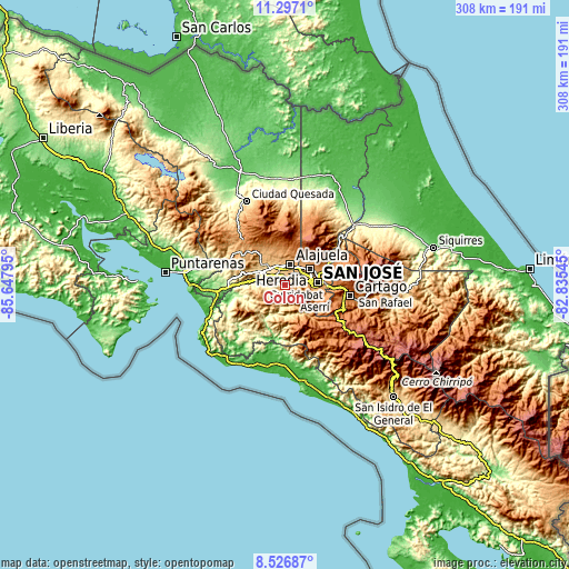
| \ | Map #1 | Map #2 | Topo.Map |
| Scale [m] | 547..1650 m | 394..2212 m | × |
| Scale [ft] | 1795..5413 ft | 1293..7257 ft | × |
| Average | 914.4 m = 3000 ft | 946.6 m = 3106 ft | × |
| Width | 9.63 km = 6 mi | 19.25 km = 12 mi | 308 km = 191.4 mi |
| Height | 9.63 km = 6 mi | 19.25 km = 12 mi | 308 km = 191.4 mi |
| ↑Max Latitude | 9.958196° | 10.001476° | 11.2971° |
| Latitude at center | 9.91491° | 9.91491° | 9.91491° |
| ↓Min Latitude | 9.871618° | 9.828321° | 8.52687° |
| ← Min Longitude | -84.285645° | -84.329591° | -85.64795° |
| Longitude center | -84.2417° | -84.2417° | -84.2417° |
| →Max Longitude | -84.197755° | -84.153809° | -82.83545° |
Nearby cities:
Cities around Colón sort by population:
• Alajuela elevation 954 m
11.7 km,  16°
16°
• San Rafael Abajo 826 m
10.7 km,  209°
209°
• San Rafael 1060 m
11.5 km,  82°
82°
• Escazú 1111 m
11.2 km,  87°
87°
• San Antonio 937 m
9.9 km,  40°
40°
• Santiago 1109 m
11 km,  226°
226°
• Santa Ana 909 m
6.8 km,  73°
73°
• Llorente 1041 m
13.3 km,  45°
45°
• La Asunción 956 m
10.4 km, 46°
• Carrillos 834 m
13.2 km,  344°
344°
• Salitral 1038 m
6.9 km, 93°
• Palmichal 1098 m
9.5 km,  154°
154°
Multilingual:
 En español:
Colón elevación 801 m.
 En France:
Colón élévation 801 m.


Sources and notes:
- [note 1] Map square and city borders are not equal. Map elevation data is calculated only from area inside that square.
- [src 1] Elevation data from geonames database provided with same terms of usage.
- [src 2] The elevation map of Colón is generated using elevation data from NASA's 3 arcsec (90m) resolution SRTM data.
- [src 3] Base (background) map © OpenStreetMap contributors tiles are generated by Geofabrik and OpenTopoMap.
Copyright & License:
This Colón Elevation Map is licensed under CC BY-SA. You may reuse any part from this page, if you give a proper credit by linking to this URL:
 More info on terms of use page.