San Martín elevation
San Martín (Cesar), Colombia elevation is 112 meters and San Martín elevation in feet is 367 ft above sea level [src 1]. San Martín is a seat of a second-order administrative division (feature code) with elevation that is 1037 meters (3402 ft) smaller than average city elevation in Colombia.
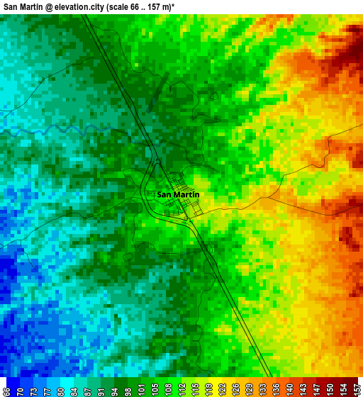
Below is the Elevation map of San Martín, which displays elevation range with different colors. Scale of the first map is from 66 to 157 m (217 to 515 ft) with average elevation of 103.4 meters (=339 ft) [note 1]
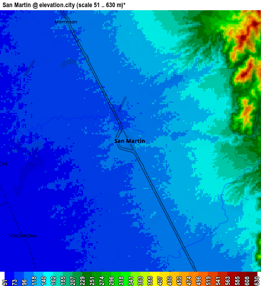
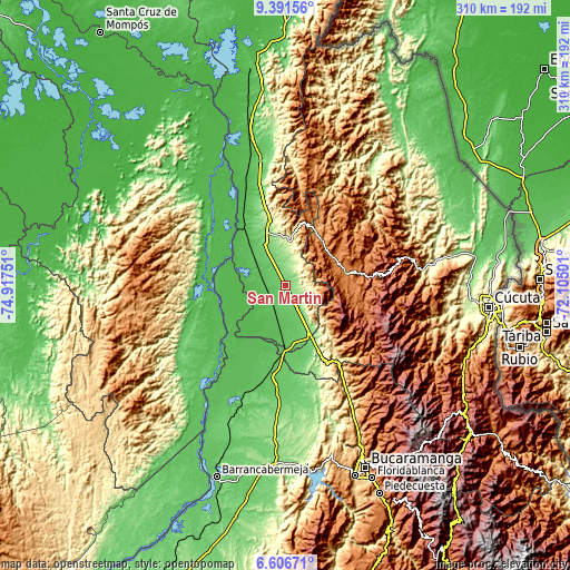
These maps also provides idea of topography and contour of this city, they are displayed at different zoom levels. More info about maps, scale and edge coordinates you can find below images.
| \ | Map #1 | Map #2 | Topo.Map |
| Scale [m] | 66..157 m | 51..630 m | × |
| Scale [ft] | 217..515 ft | 167..2067 ft | × |
| Average | 103.4 m = 339 ft | 123.5 m = 405 ft | × |
| Width | 9.68 km = 6 mi | 19.35 km = 12 mi | 309.6 km = 192.4 mi |
| Height | 9.68 km = 6 mi | 19.35 km = 12 mi | 309.7 km = 192.4 mi |
| ↑Max Latitude | 8.045025° | 8.088536° | 9.39156° |
| Latitude at center | 8.00151° | 8.00151° | 8.00151° |
| ↓Min Latitude | 7.95799° | 7.914466° | 6.60671° |
| ← Min Longitude | -73.555205° | -73.599151° | -74.91751° |
| Longitude center | -73.51126° | -73.51126° | -73.51126° |
| →Max Longitude | -73.467315° | -73.423369° | -72.10501° |
Nearby cities:
Cities around San Martín sort by population:
• Ocaña elevation 1197 m
31.3 km,  33°
33°
• Aguachica 164 m
36 km,  341°
341°
• Morales 42 m
49.8 km,  307°
307°
• Ábrego 1395 m
33.2 km,  74°
74°
• San Alberto 118 m
29.8 km,  153°
153°
• Gamarra 42 m
43.9 km,  324°
324°
• Simití 48 m
47.9 km,  264°
264°
• Río de Oro 1164 m
35.2 km,  23°
23°
• González 1309 m
45.5 km, 18°
• Hacarí 1247 m
53.6 km,  48°
48°
• La Playa 1574 m
38.2 km, 51°
• La Esperanza 266 m
44.9 km, 153°
Multilingual:
 En español:
San Martín elevación 112 m.
 En France:
San Martín élévation 112 m.
 Auf Deutsch:
San Martín höhe über dem Meeresspiegel ist 112 m.

Sources and notes:
- [note 1] Map square and city borders are not equal. Map elevation data is calculated only from area inside that square.
- [src 1] Elevation data from geonames database provided with same terms of usage.
- [src 2] The elevation map of San Martín is generated using elevation data from NASA's 3 arcsec (90m) resolution SRTM data.
- [src 3] Base (background) map © OpenStreetMap contributors tiles are generated by Geofabrik and OpenTopoMap.
Copyright & License:
This San Martín Elevation Map is licensed under CC BY-SA. You may reuse any part from this page, if you give a proper credit by linking to this URL:
 More info on terms of use page.