Gamarra elevation
Gamarra (Cesar), Colombia elevation is 42 meters and Gamarra elevation in feet is 138 ft above sea level [src 1]. Gamarra is a seat of a second-order administrative division (feature code) with elevation that is 1107 meters (3632 ft) smaller than average city elevation in Colombia.
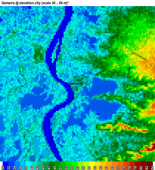
Below is the Elevation map of Gamarra, which displays elevation range with different colors. Scale of the first map is from 30 to 84 m (98 to 276 ft) with average elevation of 42.6 meters (=140 ft) [note 1]
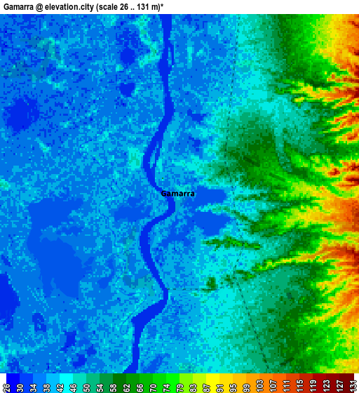
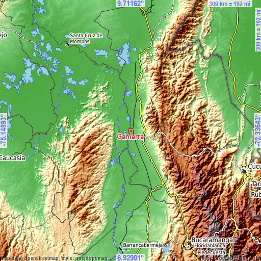
These maps also provides idea of topography and contour of this city, they are displayed at different zoom levels. More info about maps, scale and edge coordinates you can find below images.
| \ | Map #1 | Map #2 | Topo.Map |
| Scale [m] | 30..84 m | 26..131 m | × |
| Scale [ft] | 98..276 ft | 85..430 ft | × |
| Average | 42.6 m = 140 ft | 48.6 m = 159 ft | × |
| Width | 9.67 km = 6 mi | 19.34 km = 12 mi | 309.4 km = 192.3 mi |
| Height | 9.67 km = 6 mi | 19.34 km = 12 mi | 309.4 km = 192.3 mi |
| ↑Max Latitude | 8.36627° | 8.409745° | 9.71162° |
| Latitude at center | 8.32279° | 8.32279° | 8.32279° |
| ↓Min Latitude | 8.279305° | 8.235815° | 6.92901° |
| ← Min Longitude | -73.786625° | -73.830571° | -75.14893° |
| Longitude center | -73.74268° | -73.74268° | -73.74268° |
| →Max Longitude | -73.698735° | -73.654789° | -72.33643° |
Nearby cities:
Cities around Gamarra sort by population:
• Ocaña elevation 1197 m
43.6 km,  102°
102°
• Aguachica 164 m
14 km, 96°
• Morales 42 m
14.9 km,  249°
249°
• Pelaya 73 m
41.5 km,  11°
11°
• Río Viejo 37 m
31.3 km,  340°
340°
• La Gloria 36 m
33.6 km,  348°
348°
• Río de Oro 1164 m
39.5 km,  94°
94°
• González 1309 m
40.6 km,  79°
79°
• Arenal 44 m
26.8 km,  304°
304°
• El Carmen 712 m
38.6 km,  57°
57°
• Regidor 36 m
39.1 km, 347°
• Norosí 50 m
39.6 km,  305°
305°
Multilingual:
 En español:
Gamarra elevación 42 m.
 En France:
Gamarra élévation 42 m.


Sources and notes:
- [note 1] Map square and city borders are not equal. Map elevation data is calculated only from area inside that square.
- [src 1] Elevation data from geonames database provided with same terms of usage.
- [src 2] The elevation map of Gamarra is generated using elevation data from NASA's 3 arcsec (90m) resolution SRTM data.
- [src 3] Base (background) map © OpenStreetMap contributors tiles are generated by Geofabrik and OpenTopoMap.
Copyright & License:
This Gamarra Elevation Map is licensed under CC BY-SA. You may reuse any part from this page, if you give a proper credit by linking to this URL:
 More info on terms of use page.