Aguachica elevation
Aguachica (Cesar), Colombia elevation is 164 meters and Aguachica elevation in feet is 538 ft above sea level [src 1]. Aguachica is a seat of a second-order administrative division (feature code) with elevation that is 985 meters (3232 ft) smaller than average city elevation in Colombia.
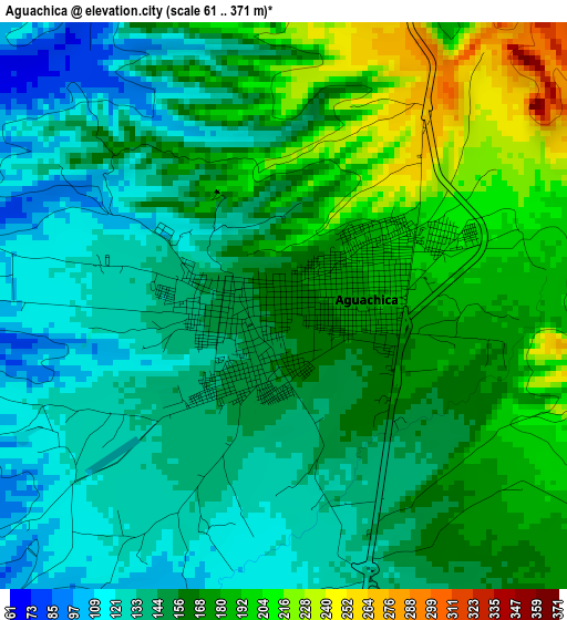
Below is the Elevation map of Aguachica, which displays elevation range with different colors. Scale of the first map is from 61 to 371 m (200 to 1217 ft) with average elevation of 159.2 meters (=522 ft) [note 1]
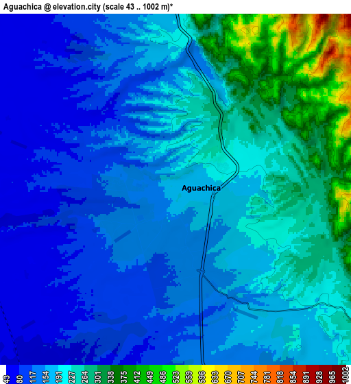
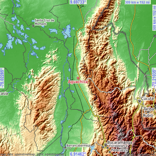
These maps also provides idea of topography and contour of this city, they are displayed at different zoom levels. More info about maps, scale and edge coordinates you can find below images.
| \ | Map #1 | Map #2 | Topo.Map |
| Scale [m] | 61..371 m | 43..1002 m | × |
| Scale [ft] | 200..1217 ft | 141..3287 ft | × |
| Average | 159.2 m = 522 ft | 187.5 m = 615 ft | × |
| Width | 9.67 km = 6 mi | 19.34 km = 12 mi | 309.4 km = 192.3 mi |
| Height | 9.67 km = 6 mi | 19.34 km = 12 mi | 309.4 km = 192.3 mi |
| ↑Max Latitude | 8.351922° | 8.395398° | 9.69733° |
| Latitude at center | 8.30844° | 8.30844° | 8.30844° |
| ↓Min Latitude | 8.264954° | 8.221462° | 6.91462° |
| ← Min Longitude | -73.660545° | -73.704491° | -75.02285° |
| Longitude center | -73.6166° | -73.6166° | -73.6166° |
| →Max Longitude | -73.572655° | -73.528709° | -72.21035° |
Nearby cities:
Cities around Aguachica sort by population:
• Ocaña elevation 1197 m
29.7 km,  105°
105°
• Morales 42 m
28 km,  262°
262°
• Gamarra 42 m
14 km,  276°
276°
• San Martín 112 m
36 km,  161°
161°
• Río Viejo 37 m
39.5 km,  321°
321°
• La Gloria 36 m
40.1 km,  329°
329°
• Río de Oro 1164 m
25.6 km,  94°
94°
• González 1309 m
27.6 km,  70°
70°
• Arenal 44 m
39.7 km,  295°
295°
• El Carmen 712 m
29.2 km,  39°
39°
• Teorama 1006 m
38.7 km, 68°
• Convención 931 m
35.5 km,  59°
59°
Multilingual:
 En español:
Aguachica elevación 164 m.
 En France:
Aguachica élévation 164 m.
 Auf Deutsch:
Aguachica höhe über dem Meeresspiegel ist 164 m.

Sources and notes:
- [note 1] Map square and city borders are not equal. Map elevation data is calculated only from area inside that square.
- [src 1] Elevation data from geonames database provided with same terms of usage.
- [src 2] The elevation map of Aguachica is generated using elevation data from NASA's 3 arcsec (90m) resolution SRTM data.
- [src 3] Base (background) map © OpenStreetMap contributors tiles are generated by Geofabrik and OpenTopoMap.
Copyright & License:
This Aguachica Elevation Map is licensed under CC BY-SA. You may reuse any part from this page, if you give a proper credit by linking to this URL:
 More info on terms of use page.