Hacarí elevation
Hacarí (Norte de Santander), Colombia elevation is 1247 meters and Hacarí elevation in feet is 4091 ft above sea level [src 1]. Hacarí is a seat of a second-order administrative division (feature code) with elevation that is 98 meters (322 ft) bigger than average city elevation in Colombia.
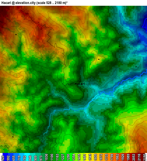
Below is the Elevation map of Hacarí, which displays elevation range with different colors. Scale of the first map is from 528 to 2180 m (1732 to 7152 ft) with average elevation of 1268.5 meters (=4162 ft) [note 1]
These maps also provides idea of topography and contour of this city, they are displayed at different zoom levels. More info about maps, scale and edge coordinates you can find below images.
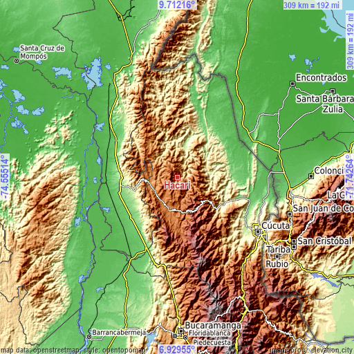
| \ | Map #1 | Topo.Map |
| Scale [m] | 528..2180 m | × |
| Scale [ft] | 1732..7152 ft | × |
| Average | 1268.5 m = 4162 ft | × |
| Width | 9.67 km = 6 mi | 309.4 km = 192.3 mi |
| Height | 9.67 km = 6 mi | 309.4 km = 192.3 mi |
| ↑Max Latitude | 8.36681° | 9.71216° |
| Latitude at center | 8.32333° | 8.32333° |
| ↓Min Latitude | 8.279845° | 6.92955° |
| ← Min Longitude | -73.192835° | -74.55514° |
| Longitude center | -73.14889° | -73.14889° |
| →Max Longitude | -73.104945° | -71.74264° |
Nearby cities:
Cities around Hacarí sort by population:
• Ocaña elevation 1197 m
24.7 km,  247°
247°
• Ábrego 1395 m
28.1 km,  196°
196°
• Sardinata 309 m
46.7 km,  124°
124°
• Río de Oro 1164 m
26.2 km,  262°
262°
• González 1309 m
26.5 km,  286°
286°
• El Carmen 712 m
38.9 km,  302°
302°
• El Tarra 197 m
28.7 km,  11°
11°
• San Calixto 1640 m
10.9 km,  323°
323°
• La Playa 1574 m
15.7 km,  218°
218°
• Bucarasica 1167 m
44.3 km,  135°
135°
• Convención 931 m
26.3 km,  307°
307°
• Teorama 1006 m
20 km, 309°
Multilingual:
 En español:
Hacarí elevación 1247 m.
 En France:
Hacarí élévation 1247 m.


Sources and notes:
- [note 1] Map square and city borders are not equal. Map elevation data is calculated only from area inside that square.
- [src 1] Elevation data from geonames database provided with same terms of usage.
- [src 2] The elevation map of Hacarí is generated using elevation data from NASA's 3 arcsec (90m) resolution SRTM data.
- [src 3] Base (background) map © OpenStreetMap contributors tiles are generated by Geofabrik and OpenTopoMap.
Copyright & License:
This Hacarí Elevation Map is licensed under CC BY-SA. You may reuse any part from this page, if you give a proper credit by linking to this URL:
 More info on terms of use page.