Cantagallo elevation
Cantagallo (Bolívar), Colombia elevation is 25 meters and Cantagallo elevation in feet is 82 ft above sea level [src 1]. Cantagallo is a seat of a second-order administrative division (feature code) with elevation that is 1124 meters (3688 ft) smaller than average city elevation in Colombia.
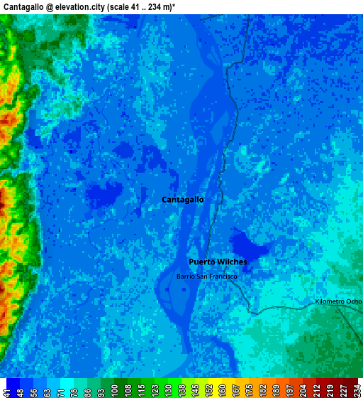
Below is the Elevation map of Cantagallo, which displays elevation range with different colors. Scale of the first map is from 41 to 78 m (135 to 256 ft) with average elevation of 61.2 meters (=201 ft) [note 1]
These maps also provides idea of topography and contour of this city, they are displayed at different zoom levels. More info about maps, scale and edge coordinates you can find below images.

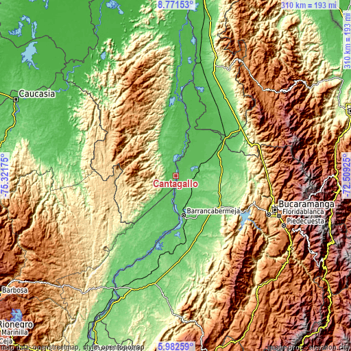
| \ | Map #1 | Map #2 | Topo.Map |
| Scale [m] | 41..78 m | 41..234 m | × |
| Scale [ft] | 135..256 ft | 135..768 ft | × |
| Average | 61.2 m = 201 ft | 69.9 m = 229 ft | × |
| Width | 9.69 km = 6 mi | 19.38 km = 12 mi | 310.1 km = 192.7 mi |
| Height | 9.69 km = 6 mi | 19.38 km = 12 mi | 310.1 km = 192.7 mi |
| ↑Max Latitude | 7.422839° | 7.466414° | 8.77153° |
| Latitude at center | 7.37926° | 7.37926° | 7.37926° |
| ↓Min Latitude | 7.335677° | 7.292089° | 5.98259° |
| ← Min Longitude | -73.959445° | -74.003391° | -75.32175° |
| Longitude center | -73.9155° | -73.9155° | -73.9155° |
| →Max Longitude | -73.871555° | -73.827609° | -72.50925° |
Nearby cities:
Cities around Cantagallo sort by population:
• Barrancabermeja elevation 83 m
35.5 km,  169°
169°
• Puerto Wilches 67 m
4.1 km,  148°
148°
• Sabana de Torres 137 m
46.3 km,  88°
88°
• San Vicente de Chucurí 645 m
78.6 km,  134°
134°
• San Alberto 118 m
71.6 km,  53°
53°
• Santa Rosa del Sur 628 m
66.8 km,  346°
346°
• Yondó 72 m
41.5 km,  179°
179°
• San Martín 112 m
82.3 km,  32°
32°
• Simití 48 m
64.4 km,  357°
357°
• El Playón 439 m
79.2 km,  82°
82°
• La Esperanza 266 m
71 km,  65°
65°
• San Pablo 63 m
11 km, 355°
Multilingual:
 En español:
Cantagallo elevación 25 m.
 En France:
Cantagallo élévation 25 m.
 Auf Deutsch:
Cantagallo höhe über dem Meeresspiegel ist 25 m.

Sources and notes:
- [note 1] Map square and city borders are not equal. Map elevation data is calculated only from area inside that square.
- [src 1] Elevation data from geonames database provided with same terms of usage.
- [src 2] The elevation map of Cantagallo is generated using elevation data from NASA's 3 arcsec (90m) resolution SRTM data.
- [src 3] Base (background) map © OpenStreetMap contributors tiles are generated by Geofabrik and OpenTopoMap.
Copyright & License:
This Cantagallo Elevation Map is licensed under CC BY-SA. You may reuse any part from this page, if you give a proper credit by linking to this URL:
 More info on terms of use page.