Sabana de Torres elevation
Sabana de Torres (Santander), Colombia elevation is 137 meters and Sabana de Torres elevation in feet is 449 ft above sea level [src 1]. Sabana de Torres is a seat of a second-order administrative division (feature code) with elevation that is 1012 meters (3320 ft) smaller than average city elevation in Colombia.
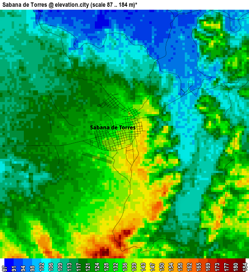
Below is the Elevation map of Sabana de Torres, which displays elevation range with different colors. Scale of the first map is from 87 to 184 m (285 to 604 ft) with average elevation of 120.2 meters (=394 ft) [note 1]
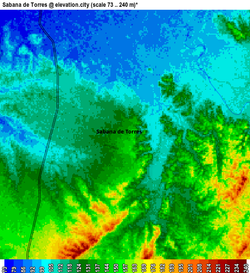
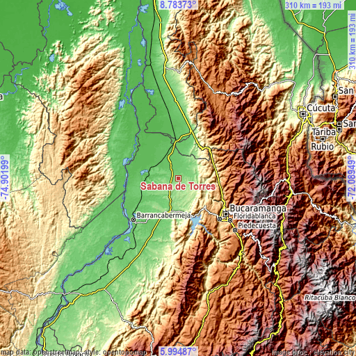
These maps also provides idea of topography and contour of this city, they are displayed at different zoom levels. More info about maps, scale and edge coordinates you can find below images.
| \ | Map #1 | Map #2 | Topo.Map |
| Scale [m] | 87..184 m | 73..240 m | × |
| Scale [ft] | 285..604 ft | 240..787 ft | × |
| Average | 120.2 m = 394 ft | 123.3 m = 405 ft | × |
| Width | 9.69 km = 6 mi | 19.38 km = 12 mi | 310.1 km = 192.7 mi |
| Height | 9.69 km = 6 mi | 19.38 km = 12 mi | 310.1 km = 192.7 mi |
| ↑Max Latitude | 7.435078° | 7.478652° | 8.78373° |
| Latitude at center | 7.3915° | 7.3915° | 7.3915° |
| ↓Min Latitude | 7.347918° | 7.304331° | 5.99487° |
| ← Min Longitude | -73.539685° | -73.583631° | -74.90199° |
| Longitude center | -73.49574° | -73.49574° | -73.49574° |
| →Max Longitude | -73.451795° | -73.407849° | -72.08949° |
Nearby cities:
Cities around Sabana de Torres sort by population:
• Bucaramanga elevation 993 m
50.9 km,  125°
125°
• Girón 706 m
50.8 km, 134°
• Puerto Wilches 67 m
44.4 km,  263°
263°
• San Alberto 118 m
42.6 km,  15°
15°
• Lebrija 1016 m
43.6 km,  135°
135°
• El Playón 439 m
33.5 km,  74°
74°
• Cantagallo 25 m
46.3 km,  268°
268°
• Matanza 1588 m
53.6 km,  98°
98°
• Los Santos 1062 m
50.8 km,  119°
119°
• San Pablo 63 m
48 km,  281°
281°
• Rionegro 664 m
40.6 km,  110°
110°
• La Esperanza 266 m
33.3 km,  33°
33°
Multilingual:
 En español:
Sabana de Torres elevación 137 m.
 En France:
Sabana de Torres élévation 137 m.
 Auf Deutsch:
Sabana de Torres höhe über dem Meeresspiegel ist 137 m.

Sources and notes:
- [note 1] Map square and city borders are not equal. Map elevation data is calculated only from area inside that square.
- [src 1] Elevation data from geonames database provided with same terms of usage.
- [src 2] The elevation map of Sabana de Torres is generated using elevation data from NASA's 3 arcsec (90m) resolution SRTM data.
- [src 3] Base (background) map © OpenStreetMap contributors tiles are generated by Geofabrik and OpenTopoMap.
Copyright & License:
This Sabana de Torres Elevation Map is licensed under CC BY-SA. You may reuse any part from this page, if you give a proper credit by linking to this URL:
 More info on terms of use page.