Matanza elevation
Matanza (Santander), Colombia elevation is 1588 meters and Matanza elevation in feet is 5210 ft above sea level [src 1]. Matanza is a seat of a second-order administrative division (feature code) with elevation that is 439 meters (1440 ft) bigger than average city elevation in Colombia.
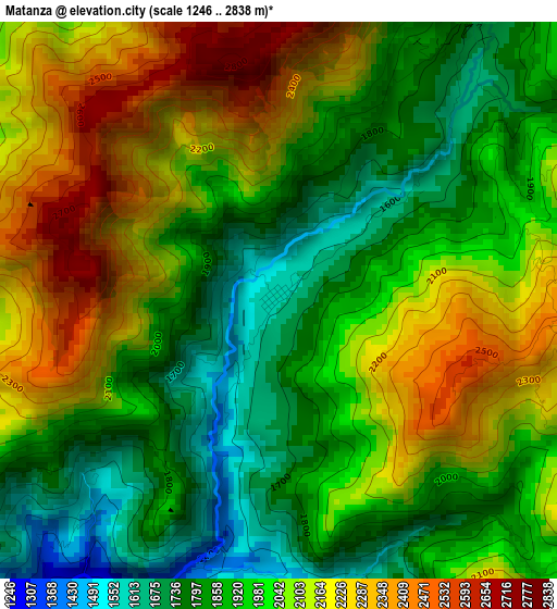
Below is the Elevation map of Matanza, which displays elevation range with different colors. Scale of the first map is from 1246 to 2838 m (4088 to 9311 ft) with average elevation of 2007.6 meters (=6587 ft) [note 1]
These maps also provides idea of topography and contour of this city, they are displayed at different zoom levels. More info about maps, scale and edge coordinates you can find below images.
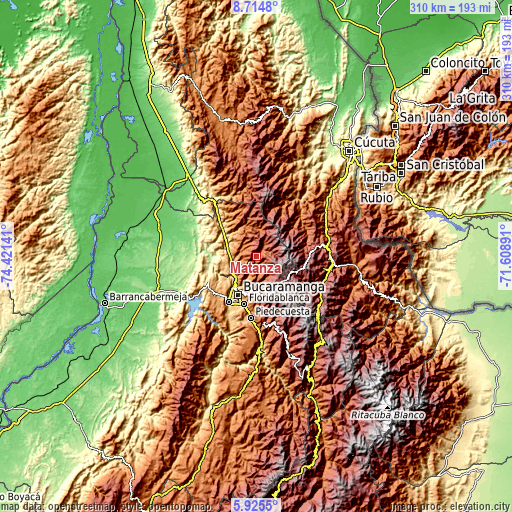
| \ | Map #1 | Topo.Map |
| Scale [m] | 1246..2838 m | × |
| Scale [ft] | 4088..9311 ft | × |
| Average | 2007.6 m = 6587 ft | × |
| Width | 9.69 km = 6 mi | 310.1 km = 192.7 mi |
| Height | 9.69 km = 6 mi | 310.2 km = 192.7 mi |
| ↑Max Latitude | 7.365915° | 8.7148° |
| Latitude at center | 7.32233° | 7.32233° |
| ↓Min Latitude | 7.278741° | 5.9255° |
| ← Min Longitude | -73.059105° | -74.42141° |
| Longitude center | -73.01516° | -73.01516° |
| →Max Longitude | -72.971215° | -71.60891° |
Nearby cities:
Cities around Matanza sort by population:
• Bucaramanga elevation 993 m
24.8 km,  207°
207°
• Floridablanca 928 m
30 km,  195°
195°
• El Playón 439 m
26.5 km,  308°
308°
• Los Santos 1062 m
19 km, 206°
• Silos 2730 m
31.4 km,  114°
114°
• Vetas 3257 m
15.9 km,  95°
95°
• Mutiscua 2609 m
29.7 km,  94°
94°
• Suratá 1748 m
6 km,  35°
35°
• Charta 2000 m
7 km,  131°
131°
• Tona 1893 m
14.5 km,  157°
157°
• California 2422 m
8.2 km,  69°
69°
• Rionegro 664 m
16.2 km,  246°
246°
Multilingual:
 En español:
Matanza elevación 1588 m.
 En France:
Matanza élévation 1588 m.
 Auf Deutsch:
Matanza höhe über dem Meeresspiegel ist 1588 m.

Sources and notes:
- [note 1] Map square and city borders are not equal. Map elevation data is calculated only from area inside that square.
- [src 1] Elevation data from geonames database provided with same terms of usage.
- [src 2] The elevation map of Matanza is generated using elevation data from NASA's 3 arcsec (90m) resolution SRTM data.
- [src 3] Base (background) map © OpenStreetMap contributors tiles are generated by Geofabrik and OpenTopoMap.
Copyright & License:
This Matanza Elevation Map is licensed under CC BY-SA. You may reuse any part from this page, if you give a proper credit by linking to this URL:
 More info on terms of use page.