Yondó elevation
Yondó (Antioquia), Colombia elevation is 72 meters and Yondó elevation in feet is 236 ft above sea level [src 1]. Yondó is a seat of a second-order administrative division (feature code) with elevation that is 1077 meters (3533 ft) smaller than average city elevation in Colombia.
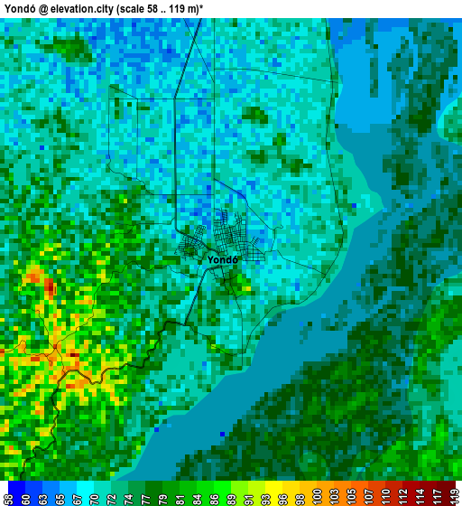
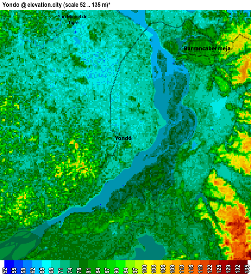
Below is the Elevation map of Yondó, which displays elevation range with different colors. Scale of the first map is from 58 to 119 m (190 to 390 ft) with average elevation of 74.1 meters (=243 ft) [note 1]
These maps also provides idea of topography and contour of this city, they are displayed at different zoom levels. More info about maps, scale and edge coordinates you can find below images.
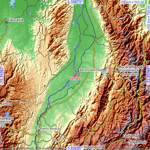
| \ | Map #1 | Map #2 | Topo.Map |
| Scale [m] | 58..119 m | 52..135 m | × |
| Scale [ft] | 190..390 ft | 171..443 ft | × |
| Average | 74.1 m = 243 ft | 77.4 m = 254 ft | × |
| Width | 9.7 km = 6 mi | 19.4 km = 12.1 mi | 310.4 km = 192.9 mi |
| Height | 9.7 km = 6 mi | 19.4 km = 12.1 mi | 310.4 km = 192.9 mi |
| ↑Max Latitude | 7.049825° | 7.093436° | 8.39973° |
| Latitude at center | 7.00621° | 7.00621° | 7.00621° |
| ↓Min Latitude | 6.962591° | 6.918968° | 5.60851° |
| ← Min Longitude | -73.953665° | -73.997611° | -75.31597° |
| Longitude center | -73.90972° | -73.90972° | -73.90972° |
| →Max Longitude | -73.865775° | -73.821829° | -72.50347° |
Nearby cities:
Cities around Yondó sort by population:
• Barrancabermeja elevation 83 m
8.9 km,  42°
42°
• Puerto Wilches 67 m
38.1 km,  2°
2°
• Sabana de Torres 137 m
62.6 km,  46°
46°
• Cimitarra 156 m
77.1 km,  183°
183°
• San Vicente de Chucurí 645 m
56.9 km,  104°
104°
• Lebrija 1016 m
77.3 km,  81°
81°
• Zapatoca 1696 m
74 km,  106°
106°
• Cantagallo 25 m
41.5 km,  359°
359°
• Betulia 1823 m
70.1 km, 99°
• El Carmen de Chucurí 775 m
55.8 km,  127°
127°
• Puerto Parra 96 m
42.7 km,  202°
202°
• San Pablo 63 m
52.4 km, 358°
Multilingual:
 En español:
Yondó elevación 72 m.
 En France:
Yondó élévation 72 m.


Sources and notes:
- [note 1] Map square and city borders are not equal. Map elevation data is calculated only from area inside that square.
- [src 1] Elevation data from geonames database provided with same terms of usage.
- [src 2] The elevation map of Yondó is generated using elevation data from NASA's 3 arcsec (90m) resolution SRTM data.
- [src 3] Base (background) map © OpenStreetMap contributors tiles are generated by Geofabrik and OpenTopoMap.
Copyright & License:
This Yondó Elevation Map is licensed under CC BY-SA. You may reuse any part from this page, if you give a proper credit by linking to this URL:
 More info on terms of use page.