Cepitá elevation
Cepitá (Santander), Colombia elevation is 661 meters and Cepitá elevation in feet is 2169 ft above sea level [src 1]. Cepitá is a seat of a second-order administrative division (feature code) with elevation that is 488 meters (1601 ft) smaller than average city elevation in Colombia.
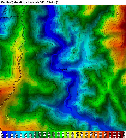
Below is the Elevation map of Cepitá, which displays elevation range with different colors. Scale of the first map is from 560 to 2242 m (1837 to 7356 ft) with average elevation of 1119.9 meters (=3674 ft) [note 1]
These maps also provides idea of topography and contour of this city, they are displayed at different zoom levels. More info about maps, scale and edge coordinates you can find below images.
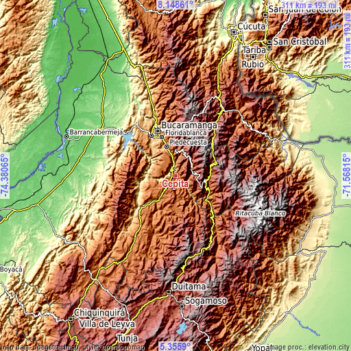
| \ | Map #1 | Topo.Map |
| Scale [m] | 560..2242 m | × |
| Scale [ft] | 1837..7356 ft | × |
| Average | 1119.9 m = 3674 ft | × |
| Width | 9.7 km = 6 mi | 310.5 km = 192.9 mi |
| Height | 9.7 km = 6 mi | 310.5 km = 192.9 mi |
| ↑Max Latitude | 6.797908° | 8.14861° |
| Latitude at center | 6.75427° | 6.75427° |
| ↓Min Latitude | 6.710628° | 5.3559° |
| ← Min Longitude | -73.018345° | -74.38065° |
| Longitude center | -72.9744° | -72.9744° |
| →Max Longitude | -72.930455° | -71.56815° |
Nearby cities:
Cities around Cepitá sort by population:
• Piedecuesta elevation 1014 m
27.3 km,  342°
342°
• San Gil 1152 m
28.1 km,  219°
219°
• Málaga 2210 m
27.4 km,  102°
102°
• Villanueva 1454 m
23.9 km,  247°
247°
• Curití 1490 m
19.5 km,  211°
211°
• San Andrés 1626 m
15.2 km,  65°
65°
• Aratoca 1803 m
8.3 km, 216°
• Guaca 2305 m
18.8 km,  43°
43°
• Molagavita 2173 m
20.4 km,  116°
116°
• Santa Bárbara 1913 m
27.3 km,  15°
15°
• Jordán 438 m
13.6 km,  260°
260°
• Los Santos 1327 m
14.4 km,  269°
269°
Multilingual:
 En español:
Cepitá elevación 661 m.
 En France:
Cepitá élévation 661 m.


Sources and notes:
- [note 1] Map square and city borders are not equal. Map elevation data is calculated only from area inside that square.
- [src 1] Elevation data from geonames database provided with same terms of usage.
- [src 2] The elevation map of Cepitá is generated using elevation data from NASA's 3 arcsec (90m) resolution SRTM data.
- [src 3] Base (background) map © OpenStreetMap contributors tiles are generated by Geofabrik and OpenTopoMap.
Copyright & License:
This Cepitá Elevation Map is licensed under CC BY-SA. You may reuse any part from this page, if you give a proper credit by linking to this URL:
 More info on terms of use page.