San Gil elevation
San Gil (Santander), Colombia elevation is 1152 meters and San Gil elevation in feet is 3780 ft above sea level [src 1]. San Gil is a populated place (feature code) with elevation that is 3 meters (10 ft) bigger than average city elevation in Colombia.
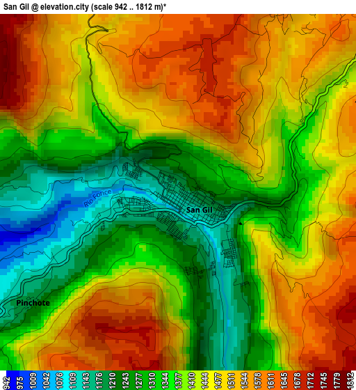
Below is the Elevation map of San Gil, which displays elevation range with different colors. Scale of the first map is from 942 to 1812 m (3091 to 5945 ft) with average elevation of 1417.9 meters (=4652 ft) [note 1]
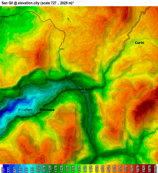
These maps also provides idea of topography and contour of this city, they are displayed at different zoom levels. More info about maps, scale and edge coordinates you can find below images.
| \ | Map #1 | Map #2 | Topo.Map |
| Scale [m] | 942..1812 m | 727..2029 m | × |
| Scale [ft] | 3091..5945 ft | 2385..6657 ft | × |
| Average | 1417.9 m = 4652 ft | 1489 m = 4885 ft | × |
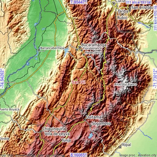
| Width | 9.71 km = 6 mi | 19.42 km = 12.1 mi | 310.6 km = 193 mi |
| Height | 9.71 km = 6 mi | 19.42 km = 12.1 mi | 310.7 km = 193.1 mi |
| ↑Max Latitude | 6.603176° | 6.646828° | 7.95447° |
| Latitude at center | 6.55952° | 6.55952° | 6.55952° |
| ↓Min Latitude | 6.51586° | 6.472197° | 5.16065° |
| ← Min Longitude | -73.180315° | -73.224261° | -74.54262° |
| Longitude center | -73.13637° | -73.13637° | -73.13637° |
| →Max Longitude | -73.092425° | -73.048479° | -71.73012° |
Nearby cities:
Cities around San Gil sort by population:
• Socorro elevation 1234 m
17 km,  233°
233°
• Barichara 1283 m
12.8 km,  311°
311°
• Villanueva 1454 m
13.2 km,  341°
341°
• Curití 1490 m
9.1 km,  56°
56°
• Valle de San José 1243 m
12.5 km,  183°
183°
• Galán 938 m
19 km,  297°
297°
• Páramo 1406 m
16.3 km,  193°
193°
• Pinchote 1200 m
5.1 km, 233°
• Hato 1347 m
19.1 km,  264°
264°
• Cabrera 1190 m
12.7 km,  286°
286°
• Palmar 907 m
17.4 km, 261°
• Jordán 438 m
19.8 km,  13°
13°
Multilingual:
 En español:
San Gil elevación 1152 m.
 En France:
San Gil élévation 1152 m.
 Auf Deutsch:
San Gil höhe über dem Meeresspiegel ist 1152 m.

Sources and notes:
- [note 1] Map square and city borders are not equal. Map elevation data is calculated only from area inside that square.
- [src 1] Elevation data from geonames database provided with same terms of usage.
- [src 2] The elevation map of San Gil is generated using elevation data from NASA's 3 arcsec (90m) resolution SRTM data.
- [src 3] Base (background) map © OpenStreetMap contributors tiles are generated by Geofabrik and OpenTopoMap.
Copyright & License:
This San Gil Elevation Map is licensed under CC BY-SA. You may reuse any part from this page, if you give a proper credit by linking to this URL:
 More info on terms of use page.