Jordán elevation
Jordán (Santander), Colombia elevation is 438 meters and Jordán elevation in feet is 1437 ft above sea level [src 1]. Jordán is a seat of a second-order administrative division (feature code) with elevation that is 711 meters (2333 ft) smaller than average city elevation in Colombia.
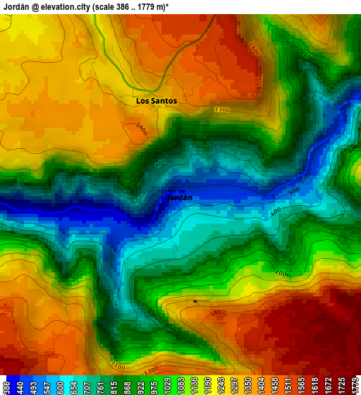
Below is the Elevation map of Jordán, which displays elevation range with different colors. Scale of the first map is from 386 to 1779 m (1266 to 5837 ft) with average elevation of 1088.2 meters (=3570 ft) [note 1]
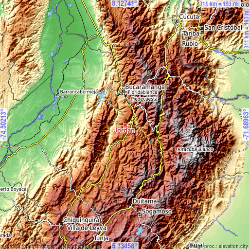
These maps also provides idea of topography and contour of this city, they are displayed at different zoom levels. More info about maps, scale and edge coordinates you can find below images.
| \ | Map #1 | Topo.Map |
| Scale [m] | 386..1779 m | × |
| Scale [ft] | 1266..5837 ft | × |
| Average | 1088.2 m = 3570 ft | × |
| Width | 9.71 km = 6 mi | 310.5 km = 192.9 mi |
| Height | 9.71 km = 6 mi | 310.6 km = 193 mi |
| ↑Max Latitude | 6.77664° | 8.12741° |
| Latitude at center | 6.733° | 6.733° |
| ↓Min Latitude | 6.689356° | 5.33458° |
| ← Min Longitude | -73.139825° | -74.50213° |
| Longitude center | -73.09588° | -73.09588° |
| →Max Longitude | -73.051935° | -71.68963° |
Nearby cities:
Cities around Jordán sort by population:
• San Gil elevation 1152 m
19.8 km,  193°
193°
• Zapatoca 1696 m
21.1 km,  295°
295°
• Barichara 1283 m
17.7 km,  232°
232°
• Villanueva 1454 m
11 km, 231°
• Curití 1490 m
14.5 km,  167°
167°
• Aratoca 1803 m
9.5 km,  116°
116°
• Betulia 1823 m
27.9 km,  311°
311°
• Galán 938 m
23.8 km,  243°
243°
• Pinchote 1200 m
23.9 km,  200°
200°
• Cepitá 661 m
13.6 km,  80°
80°
• Cabrera 1190 m
22.8 km, 226°
• Los Santos 1327 m
2.5 km,  336°
336°
Multilingual:
 En español:
Jordán elevación 438 m.
 En France:
Jordán élévation 438 m.


Sources and notes:
- [note 1] Map square and city borders are not equal. Map elevation data is calculated only from area inside that square.
- [src 1] Elevation data from geonames database provided with same terms of usage.
- [src 2] The elevation map of Jordán is generated using elevation data from NASA's 3 arcsec (90m) resolution SRTM data.
- [src 3] Base (background) map © OpenStreetMap contributors tiles are generated by Geofabrik and OpenTopoMap.
Copyright & License:
This Jordán Elevation Map is licensed under CC BY-SA. You may reuse any part from this page, if you give a proper credit by linking to this URL:
 More info on terms of use page.