Piedecuesta elevation
Piedecuesta (Santander), Colombia elevation is 1014 meters and Piedecuesta elevation in feet is 3327 ft above sea level [src 1]. Piedecuesta is a seat of a second-order administrative division (feature code) with elevation that is 135 meters (443 ft) smaller than average city elevation in Colombia.
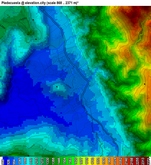
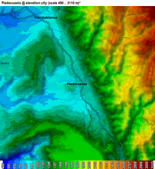
Below is the Elevation map of Piedecuesta, which displays elevation range with different colors. Scale of the first map is from 868 to 2371 m (2848 to 7779 ft) with average elevation of 1232.5 meters (=4044 ft) [note 1]
These maps also provides idea of topography and contour of this city, they are displayed at different zoom levels. More info about maps, scale and edge coordinates you can find below images.
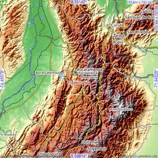
| \ | Map #1 | Map #2 | Topo.Map |
| Scale [m] | 868..2371 m | 490..3110 m | × |
| Scale [ft] | 2848..7779 ft | 1608..10203 ft | × |
| Average | 1232.5 m = 4044 ft | 1459.1 m = 4787 ft | × |
| Width | 9.7 km = 6 mi | 19.4 km = 12.1 mi | 310.4 km = 192.9 mi |
| Height | 9.7 km = 6 mi | 19.4 km = 12.1 mi | 310.4 km = 192.9 mi |
| ↑Max Latitude | 7.031507° | 7.07512° | 8.38147° |
| Latitude at center | 6.98789° | 6.98789° | 6.98789° |
| ↓Min Latitude | 6.944269° | 6.900644° | 5.59014° |
| ← Min Longitude | -73.093475° | -73.137421° | -74.45578° |
| Longitude center | -73.04953° | -73.04953° | -73.04953° |
| →Max Longitude | -73.005585° | -72.961639° | -71.64328° |
Nearby cities:
Cities around Piedecuesta sort by population:
• Bucaramanga elevation 993 m
17.1 km,  333°
333°
• Floridablanca 928 m
9.2 km, 333°
• Girón 706 m
16 km,  303°
303°
• Lebrija 1016 m
23.2 km,  306°
306°
• Betulia 1823 m
27.6 km,  249°
249°
• Guaca 2305 m
24.7 km,  120°
120°
• Los Santos 1062 m
20.8 km,  346°
346°
• Tona 1893 m
25.6 km,  21°
21°
• Cepitá 661 m
27.3 km,  162°
162°
• Santa Bárbara 1913 m
15.7 km,  89°
89°
• Jordán 438 m
28.8 km,  190°
190°
• Los Santos 1327 m
26.8 km, 193°
Multilingual:
 En español:
Piedecuesta elevación 1014 m.
 En France:
Piedecuesta élévation 1014 m.
 Auf Deutsch:
Piedecuesta höhe über dem Meeresspiegel ist 1014 m.

Sources and notes:
- [note 1] Map square and city borders are not equal. Map elevation data is calculated only from area inside that square.
- [src 1] Elevation data from geonames database provided with same terms of usage.
- [src 2] The elevation map of Piedecuesta is generated using elevation data from NASA's 3 arcsec (90m) resolution SRTM data.
- [src 3] Base (background) map © OpenStreetMap contributors tiles are generated by Geofabrik and OpenTopoMap.
Copyright & License:
This Piedecuesta Elevation Map is licensed under CC BY-SA. You may reuse any part from this page, if you give a proper credit by linking to this URL:
 More info on terms of use page.