El Bagre elevation
El Bagre (Antioquia), Colombia elevation is 51 meters and El Bagre elevation in feet is 167 ft above sea level [src 1]. El Bagre is a populated place (feature code) with elevation that is 1098 meters (3602 ft) smaller than average city elevation in Colombia.
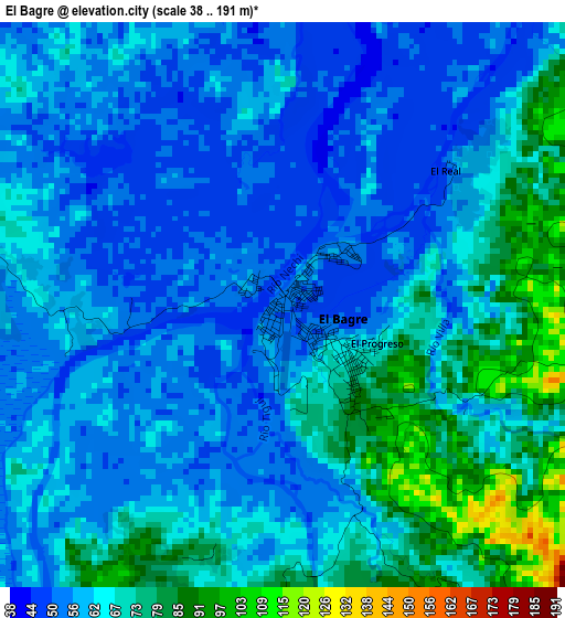
Below is the Elevation map of El Bagre, which displays elevation range with different colors. Scale of the first map is from 38 to 191 m (125 to 627 ft) with average elevation of 63.2 meters (=207 ft) [note 1]
These maps also provides idea of topography and contour of this city, they are displayed at different zoom levels. More info about maps, scale and edge coordinates you can find below images.
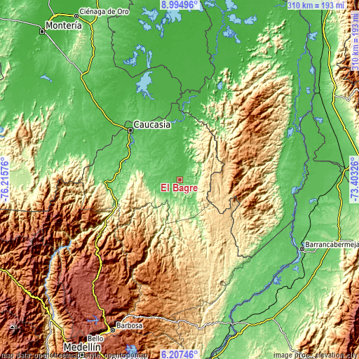
| \ | Map #1 | Map #2 | Topo.Map |
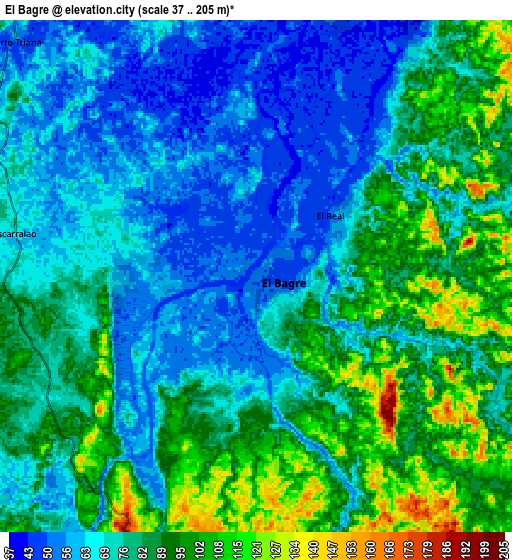
| Scale [m] | 38..191 m | 37..205 m | × |
| Scale [ft] | 125..627 ft | 121..673 ft | × |
| Average | 63.2 m = 207 ft | 78.6 m = 258 ft | × |
| Width | 9.69 km = 6 mi | 19.37 km = 12 mi | 309.9 km = 192.6 mi |
| Height | 9.69 km = 6 mi | 19.37 km = 12 mi | 310 km = 192.6 mi |
| ↑Max Latitude | 7.647027° | 7.690579° | 8.99496° |
| Latitude at center | 7.60347° | 7.60347° | 7.60347° |
| ↓Min Latitude | 7.559909° | 7.516343° | 6.20746° |
| ← Min Longitude | -74.853455° | -74.897401° | -76.21576° |
| Longitude center | -74.80951° | -74.80951° | -74.80951° |
| →Max Longitude | -74.765565° | -74.721619° | -73.40326° |
Nearby cities:
Cities around El Bagre sort by population:
• Caucasia elevation 50 m
60 km,  315°
315°
• Segovia 680 m
59.5 km,  168°
168°
• San Carlos 59 m
21.3 km,  10°
10°
• Zaragoza 66 m
14.3 km,  207°
207°
• Pueblo Nuevo 32 m
72.8 km,  346°
346°
• Nechí 31 m
54.7 km,  3°
3°
• Remedios 641 m
65.2 km, 168°
• Cáceres 95 m
59.4 km,  267°
267°
• Cruces de Anorí 853 m
54.6 km, 211°
• San Jacinto del Cauca 29 m
72.5 km, 7°
• Anorí 1585 m
69.8 km, 212°
• Tarazá 92 m
65.2 km, 268°
Multilingual:
 En español:
El Bagre elevación 51 m.
 En France:
El Bagre élévation 51 m.


Sources and notes:
- [note 1] Map square and city borders are not equal. Map elevation data is calculated only from area inside that square.
- [src 1] Elevation data from geonames database provided with same terms of usage.
- [src 2] The elevation map of El Bagre is generated using elevation data from NASA's 3 arcsec (90m) resolution SRTM data.
- [src 3] Base (background) map © OpenStreetMap contributors tiles are generated by Geofabrik and OpenTopoMap.
Copyright & License:
This El Bagre Elevation Map is licensed under CC BY-SA. You may reuse any part from this page, if you give a proper credit by linking to this URL:
 More info on terms of use page.