San Jacinto del Cauca elevation
San Jacinto del Cauca (Bolívar), Colombia elevation is 29 meters and San Jacinto del Cauca elevation in feet is 95 ft above sea level [src 1]. San Jacinto del Cauca is a seat of a second-order administrative division (feature code) with elevation that is 1120 meters (3675 ft) smaller than average city elevation in Colombia.
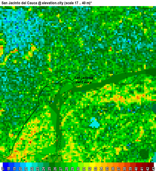
Below is the Elevation map of San Jacinto del Cauca, which displays elevation range with different colors. Scale of the first map is from 17 to 40 m (56 to 131 ft) with average elevation of 26.6 meters (=87 ft) [note 1]
These maps also provides idea of topography and contour of this city, they are displayed at different zoom levels. More info about maps, scale and edge coordinates you can find below images.
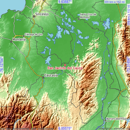
| \ | Map #1 | Topo.Map |
| Scale [m] | 17..40 m | × |
| Scale [ft] | 56..131 ft | × |
| Average | 26.6 m = 87 ft | × |
| Width | 9.67 km = 6 mi | 309.5 km = 192.3 mi |
| Height | 9.67 km = 6 mi | 309.5 km = 192.3 mi |
| ↑Max Latitude | 8.293248° | 9.63887° |
| Latitude at center | 8.24976° | 8.24976° |
| ↓Min Latitude | 8.206267° | 6.85575° |
| ← Min Longitude | -74.764735° | -76.12704° |
| Longitude center | -74.72079° | -74.72079° |
| →Max Longitude | -74.676845° | -73.31454° |
Nearby cities:
Cities around San Jacinto del Cauca sort by population:
• Caucasia elevation 50 m
59.7 km,  240°
240°
• San Marcos 25 m
63.9 km,  315°
315°
• Sucre 18 m
62.4 km,  359°
359°
• San Carlos 59 m
51.2 km,  186°
186°
• Ayapel 25 m
46.7 km,  278°
278°
• Majagual 29 m
33.9 km,  17°
17°
• Pueblo Nuevo 32 m
26.1 km,  267°
267°
• Achí 23 m
39.8 km,  26°
26°
• Nechí 31 m
18.3 km,  199°
199°
• Montecristo 84 m
27.7 km,  79°
79°
• Tiquisio 48 m
60.8 km,  55°
55°
• Guaranda 23 m
31.6 km,  39°
39°
Multilingual:
 En español:
San Jacinto del Cauca elevación 29 m.
 En France:
San Jacinto del Cauca élévation 29 m.
 Auf Deutsch:
San Jacinto del Cauca höhe über dem Meeresspiegel ist 29 m.
 На русском:
San Jacinto del Cauca высота над уровнем моря 29 м
Sources and notes:
- [note 1] Map square and city borders are not equal. Map elevation data is calculated only from area inside that square.
- [src 1] Elevation data from geonames database provided with same terms of usage.
- [src 2] The elevation map of San Jacinto del Cauca is generated using elevation data from NASA's 3 arcsec (90m) resolution SRTM data.
- [src 3] Base (background) map © OpenStreetMap contributors tiles are generated by Geofabrik and OpenTopoMap.
Copyright & License:
This San Jacinto del Cauca Elevation Map is licensed under CC BY-SA. You may reuse any part from this page, if you give a proper credit by linking to this URL:
 More info on terms of use page.