San Marcos elevation
San Marcos (Sucre), Colombia elevation is 25 meters and San Marcos elevation in feet is 82 ft above sea level [src 1]. San Marcos is a seat of a second-order administrative division (feature code) with elevation that is 1124 meters (3688 ft) smaller than average city elevation in Colombia.
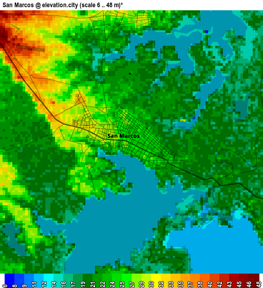
Below is the Elevation map of San Marcos, which displays elevation range with different colors. Scale of the first map is from 6 to 48 m (20 to 157 ft) with average elevation of 20.7 meters (=68 ft) [note 1]
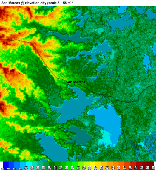
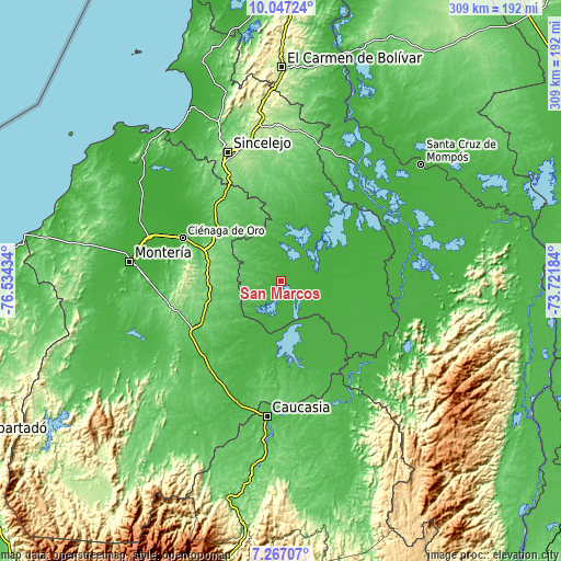
These maps also provides idea of topography and contour of this city, they are displayed at different zoom levels. More info about maps, scale and edge coordinates you can find below images.
| \ | Map #1 | Map #2 | Topo.Map |
| Scale [m] | 6..48 m | 3..58 m | × |
| Scale [ft] | 20..157 ft | 10..190 ft | × |
| Average | 20.7 m = 68 ft | 22.8 m = 75 ft | × |
| Width | 9.66 km = 6 mi | 19.32 km = 12 mi | 309.1 km = 192.1 mi |
| Height | 9.66 km = 6 mi | 19.32 km = 12 mi | 309.2 km = 192.1 mi |
| ↑Max Latitude | 8.703162° | 8.746599° | 10.04724° |
| Latitude at center | 8.65972° | 8.65972° | 8.65972° |
| ↓Min Latitude | 8.616273° | 8.572821° | 7.26707° |
| ← Min Longitude | -75.172035° | -75.215981° | -76.53434° |
| Longitude center | -75.12809° | -75.12809° | -75.12809° |
| →Max Longitude | -75.084145° | -75.040199° | -73.72184° |
Nearby cities:
Cities around San Marcos sort by population:
• Sahagún elevation 84 m
47 km,  312°
312°
• Planeta Rica 88 m
57.3 km,  241°
241°
• Sucre 18 m
47.8 km,  69°
69°
• Ayapel 25 m
38.5 km,  181°
181°
• San Benito Abad 23 m
31.9 km,  20°
20°
• Majagual 29 m
56.4 km,  103°
103°
• Galeras 92 m
56.4 km,  8°
8°
• Pueblo Nuevo 32 m
50.2 km,  158°
158°
• La Unión 49 m
26.9 km,  321°
321°
• El Roble 91 m
49.7 km,  351°
351°
• Caimito 29 m
14.5 km,  4°
4°
• Pueblo Nuevo 122 m
45.3 km,  247°
247°
Multilingual:
 En español:
San Marcos elevación 25 m.
 En France:
San Marcos élévation 25 m.
 Auf Deutsch:
San Marcos höhe über dem Meeresspiegel ist 25 m.

Sources and notes:
- [note 1] Map square and city borders are not equal. Map elevation data is calculated only from area inside that square.
- [src 1] Elevation data from geonames database provided with same terms of usage.
- [src 2] The elevation map of San Marcos is generated using elevation data from NASA's 3 arcsec (90m) resolution SRTM data.
- [src 3] Base (background) map © OpenStreetMap contributors tiles are generated by Geofabrik and OpenTopoMap.
Copyright & License:
This San Marcos Elevation Map is licensed under CC BY-SA. You may reuse any part from this page, if you give a proper credit by linking to this URL:
 More info on terms of use page.