El Paujíl elevation
El Paujíl (Caquetá, El Paujil), Colombia elevation is 343 meters and El Paujíl elevation in feet is 1125 ft above sea level [src 1]. El Paujíl is a seat of a second-order administrative division (feature code) with elevation that is 806 meters (2644 ft) smaller than average city elevation in Colombia.
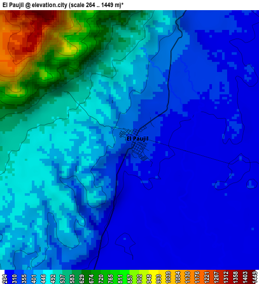
Below is the Elevation map of El Paujíl, which displays elevation range with different colors. Scale of the first map is from 264 to 1449 m (866 to 4754 ft) with average elevation of 436.7 meters (=1433 ft) [note 1]
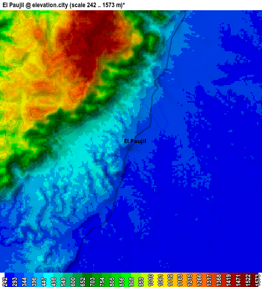
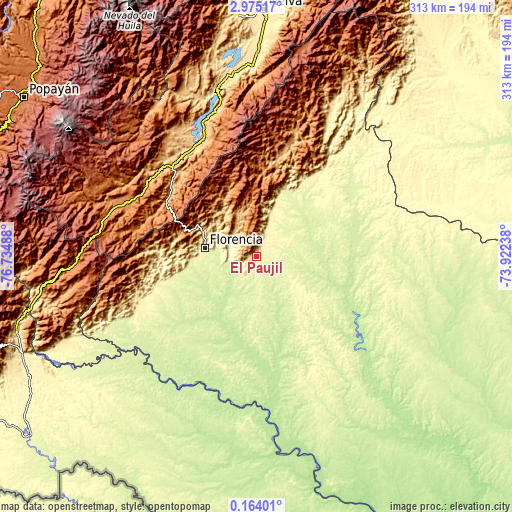
These maps also provides idea of topography and contour of this city, they are displayed at different zoom levels. More info about maps, scale and edge coordinates you can find below images.
| \ | Map #1 | Map #2 | Topo.Map |
| Scale [m] | 264..1449 m | 242..1573 m | × |
| Scale [ft] | 866..4754 ft | 794..5161 ft | × |
| Average | 436.7 m = 1433 ft | 515.7 m = 1692 ft | × |
| Width | 9.77 km = 6.1 mi | 19.54 km = 12.1 mi | 312.6 km = 194.2 mi |
| Height | 9.77 km = 6.1 mi | 19.54 km = 12.1 mi | 312.6 km = 194.2 mi |
| ↑Max Latitude | 1.613988° | 1.657916° | 2.97517° |
| Latitude at center | 1.57006° | 1.57006° | 1.57006° |
| ↓Min Latitude | 1.526131° | 1.482201° | 0.16401° |
| ← Min Longitude | -75.372575° | -75.416521° | -76.73488° |
| Longitude center | -75.32863° | -75.32863° | -75.32863° |
| →Max Longitude | -75.284685° | -75.240739° | -73.92238° |
Nearby cities:
Cities around El Paujíl sort by population:
• Florencia elevation 270 m
31.2 km,  279°
279°
• El Doncello 357 m
13 km,  22°
22°
• Puerto Rico 531 m
42.2 km,  26°
26°
• Cartagena del Chairá 221 m
60 km,  115°
115°
• Acevedo 1417 m
67.7 km,  292°
292°
• Albania 277 m
66.7 km,  246°
246°
• Belén de los Andaquíes 330 m
63.3 km, 254°
• Valparaíso 486 m
59.3 km,  225°
225°
• La Montañita 492 m
15.6 km, 230°
• Milán 443 m
36.9 km,  212°
212°
• Suaza 944 m
68.7 km,  311°
311°
• Morelia 263 m
45.1 km,  258°
258°
Multilingual:
 En español:
El Paujíl elevación 343 m.
 En France:
El Paujíl élévation 343 m.
 Auf Deutsch:
El Paujíl höhe über dem Meeresspiegel ist 343 m.

Sources and notes:
- [note 1] Map square and city borders are not equal. Map elevation data is calculated only from area inside that square.
- [src 1] Elevation data from geonames database provided with same terms of usage.
- [src 2] The elevation map of El Paujíl is generated using elevation data from NASA's 3 arcsec (90m) resolution SRTM data.
- [src 3] Base (background) map © OpenStreetMap contributors tiles are generated by Geofabrik and OpenTopoMap.
Copyright & License:
This El Paujíl Elevation Map is licensed under CC BY-SA. You may reuse any part from this page, if you give a proper credit by linking to this URL:
 More info on terms of use page.