Puerto Rico elevation
Puerto Rico (Caquetá), Colombia elevation is 531 meters and Puerto Rico elevation in feet is 1742 ft above sea level [src 1]. Puerto Rico is a seat of a second-order administrative division (feature code) with elevation that is 618 meters (2028 ft) smaller than average city elevation in Colombia.
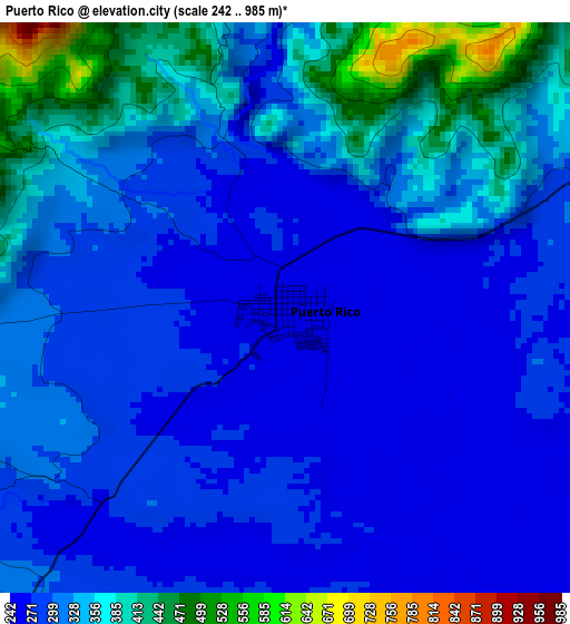
Below is the Elevation map of Puerto Rico, which displays elevation range with different colors. Scale of the first map is from 242 to 985 m (794 to 3232 ft) with average elevation of 316.3 meters (=1038 ft) [note 1]
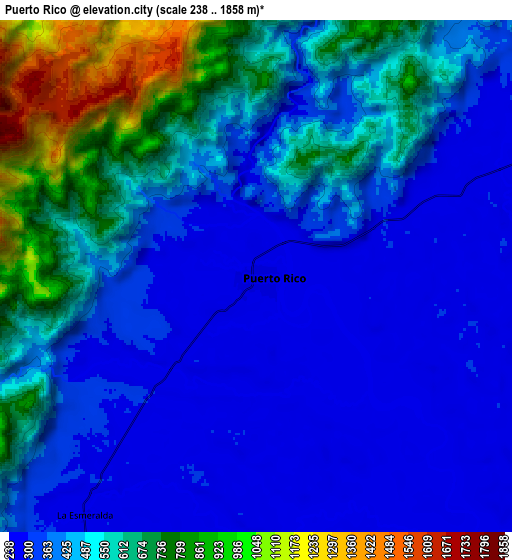
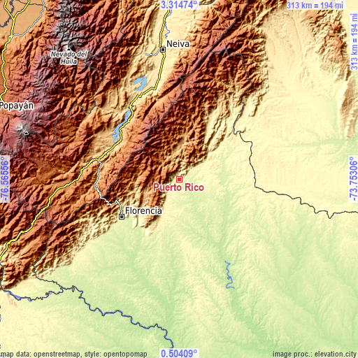
These maps also provides idea of topography and contour of this city, they are displayed at different zoom levels. More info about maps, scale and edge coordinates you can find below images.
| \ | Map #1 | Map #2 | Topo.Map |
| Scale [m] | 242..985 m | 238..1858 m | × |
| Scale [ft] | 794..3232 ft | 781..6096 ft | × |
| Average | 316.3 m = 1038 ft | 476.9 m = 1565 ft | × |
| Width | 9.77 km = 6.1 mi | 19.53 km = 12.1 mi | 312.5 km = 194.2 mi |
| Height | 9.77 km = 6.1 mi | 19.53 km = 12.1 mi | 312.5 km = 194.2 mi |
| ↑Max Latitude | 1.95391° | 1.99783° | 3.31474° |
| Latitude at center | 1.90999° | 1.90999° | 1.90999° |
| ↓Min Latitude | 1.866069° | 1.822146° | 0.50409° |
| ← Min Longitude | -75.203255° | -75.247201° | -76.56556° |
| Longitude center | -75.15931° | -75.15931° | -75.15931° |
| →Max Longitude | -75.115365° | -75.071419° | -73.75306° |
Nearby cities:
Cities around Puerto Rico sort by population:
• Florencia elevation 270 m
59.6 km,  236°
236°
• Garzón 834 m
61 km,  301°
301°
• El Doncello 357 m
29.3 km,  208°
208°
• Algeciras 995 m
70.5 km,  345°
345°
• Gigante 808 m
68.3 km,  320°
320°
• El Paujíl 343 m
42.2 km, 206°
• Cartagena del Chairá 221 m
73 km,  151°
151°
• Guadalupe 889 m
67.5 km,  280°
280°
• La Montañita 492 m
56.9 km, 212°
• Suaza 944 m
71 km, 275°
• Altamira 1039 m
71.8 km, 283°
• San Vicente del Caguán 280 m
49.6 km,  61°
61°
Multilingual:
 En español:
Puerto Rico elevación 531 m.
 En France:
Puerto Rico élévation 531 m.
 Auf Deutsch:
Puerto Rico höhe über dem Meeresspiegel ist 531 m.

Sources and notes:
- [note 1] Map square and city borders are not equal. Map elevation data is calculated only from area inside that square.
- [src 1] Elevation data from geonames database provided with same terms of usage.
- [src 2] The elevation map of Puerto Rico is generated using elevation data from NASA's 3 arcsec (90m) resolution SRTM data.
- [src 3] Base (background) map © OpenStreetMap contributors tiles are generated by Geofabrik and OpenTopoMap.
Copyright & License:
This Puerto Rico Elevation Map is licensed under CC BY-SA. You may reuse any part from this page, if you give a proper credit by linking to this URL:
 More info on terms of use page.