Acevedo elevation
Acevedo (Huila, Suaza), Colombia elevation is 1417 meters and Acevedo elevation in feet is 4649 ft above sea level [src 1]. Acevedo is a seat of a second-order administrative division (feature code) with elevation that is 268 meters (879 ft) bigger than average city elevation in Colombia.
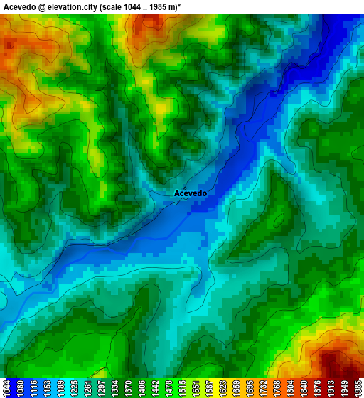
Below is the Elevation map of Acevedo, which displays elevation range with different colors. Scale of the first map is from 1044 to 1985 m (3425 to 6512 ft) with average elevation of 1348.8 meters (=4425 ft) [note 1]
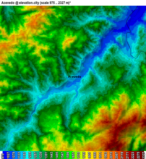
These maps also provides idea of topography and contour of this city, they are displayed at different zoom levels. More info about maps, scale and edge coordinates you can find below images.
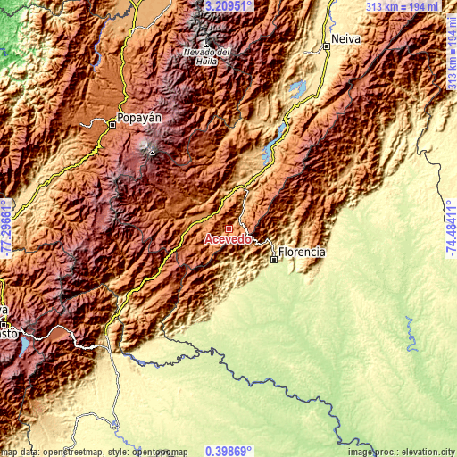
| \ | Map #1 | Map #2 | Topo.Map |
| Scale [m] | 1044..1985 m | 975..2327 m | × |
| Scale [ft] | 3425..6512 ft | 3199..7635 ft | × |
| Average | 1348.8 m = 4425 ft | 1490.1 m = 4889 ft | × |
| Width | 9.77 km = 6.1 mi | 19.54 km = 12.1 mi | 312.5 km = 194.2 mi |
| Height | 9.77 km = 6.1 mi | 19.54 km = 12.1 mi | 312.6 km = 194.2 mi |
| ↑Max Latitude | 1.848563° | 1.892485° | 3.20951° |
| Latitude at center | 1.80464° | 1.80464° | 1.80464° |
| ↓Min Latitude | 1.760716° | 1.716791° | 0.39869° |
| ← Min Longitude | -75.934305° | -75.978251° | -77.29661° |
| Longitude center | -75.89036° | -75.89036° | -75.89036° |
| →Max Longitude | -75.846415° | -75.802469° | -74.48411° |
Nearby cities:
Cities around Acevedo sort by population:
• Florencia elevation 270 m
38 km,  123°
123°
• Pitalito 1265 m
18.6 km,  287°
287°
• Timaná 1030 m
19.1 km,  346°
346°
• Guadalupe 889 m
28.7 km,  31°
31°
• Tarqui 827 m
35 km,  12°
12°
• Suaza 944 m
21.8 km, 29°
• Oporapa 1120 m
27 km,  334°
334°
• Altamira 1039 m
30.9 km,  21°
21°
• Palestina 1546 m
28.5 km,  251°
251°
• Saladoblanco 1489 m
26.9 km,  320°
320°
• Elías 1292 m
23.7 km, 346°
• Isnos 1766 m
38.2 km, 291°
Multilingual:
 En español:
Acevedo elevación 1417 m.
 En France:
Acevedo élévation 1417 m.
 Auf Deutsch:
Acevedo höhe über dem Meeresspiegel ist 1417 m.

Sources and notes:
- [note 1] Map square and city borders are not equal. Map elevation data is calculated only from area inside that square.
- [src 1] Elevation data from geonames database provided with same terms of usage.
- [src 2] The elevation map of Acevedo is generated using elevation data from NASA's 3 arcsec (90m) resolution SRTM data.
- [src 3] Base (background) map © OpenStreetMap contributors tiles are generated by Geofabrik and OpenTopoMap.
Copyright & License:
This Acevedo Elevation Map is licensed under CC BY-SA. You may reuse any part from this page, if you give a proper credit by linking to this URL:
 More info on terms of use page.