Palestina elevation
Palestina (Huila), Colombia elevation is 1546 meters and Palestina elevation in feet is 5072 ft above sea level [src 1]. Palestina is a seat of a second-order administrative division (feature code) with elevation that is 397 meters (1302 ft) bigger than average city elevation in Colombia.
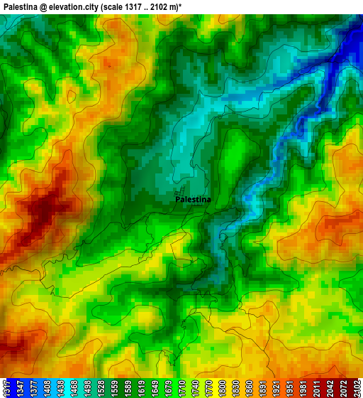
Below is the Elevation map of Palestina, which displays elevation range with different colors. Scale of the first map is from 1317 to 2102 m (4321 to 6896 ft) with average elevation of 1689.5 meters (=5543 ft) [note 1]
These maps also provides idea of topography and contour of this city, they are displayed at different zoom levels. More info about maps, scale and edge coordinates you can find below images.
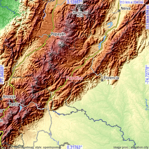
| \ | Map #1 | Topo.Map |
| Scale [m] | 1317..2102 m | × |
| Scale [ft] | 4321..6896 ft | × |
| Average | 1689.5 m = 5543 ft | × |
| Width | 9.77 km = 6.1 mi | 312.5 km = 194.2 mi |
| Height | 9.77 km = 6.1 mi | 312.6 km = 194.2 mi |
| ↑Max Latitude | 1.767545° | 3.12857° |
| Latitude at center | 1.72362° | 1.72362° |
| ↓Min Latitude | 1.679694° | 0.31763° |
| ← Min Longitude | -76.177975° | -77.54028° |
| Longitude center | -76.13403° | -76.13403° |
| →Max Longitude | -76.090085° | -74.72778° |
Nearby cities:
Cities around Palestina sort by population:
• Pitalito elevation 1265 m
17.2 km,  32°
32°
• San Agustín 1632 m
22.7 km,  319°
319°
• Timaná 1030 m
35.6 km,  39°
39°
• Isnos 1806 m
26.4 km,  333°
333°
• Acevedo 1417 m
28.5 km,  71°
71°
• Belén de los Andaquíes 330 m
44.3 km,  139°
139°
• Suaza 944 m
47 km,  53°
53°
• Oporapa 1120 m
36.7 km,  24°
24°
• Saladoblanco 1489 m
31.5 km, 18°
• Elías 1292 m
38.6 km, 33°
• San José del Fragua 587 m
47 km,  157°
157°
• Isnos 1766 m
24.4 km,  339°
339°
Multilingual:
 En español:
Palestina elevación 1546 m.
 En France:
Palestina élévation 1546 m.
 Auf Deutsch:
Palestina höhe über dem Meeresspiegel ist 1546 m.

Sources and notes:
- [note 1] Map square and city borders are not equal. Map elevation data is calculated only from area inside that square.
- [src 1] Elevation data from geonames database provided with same terms of usage.
- [src 2] The elevation map of Palestina is generated using elevation data from NASA's 3 arcsec (90m) resolution SRTM data.
- [src 3] Base (background) map © OpenStreetMap contributors tiles are generated by Geofabrik and OpenTopoMap.
Copyright & License:
This Palestina Elevation Map is licensed under CC BY-SA. You may reuse any part from this page, if you give a proper credit by linking to this URL:
 More info on terms of use page.