Morelia elevation
Morelia (Caquetá), Colombia elevation is 263 meters and Morelia elevation in feet is 863 ft above sea level [src 1]. Morelia is a seat of a second-order administrative division (feature code) with elevation that is 886 meters (2907 ft) smaller than average city elevation in Colombia.
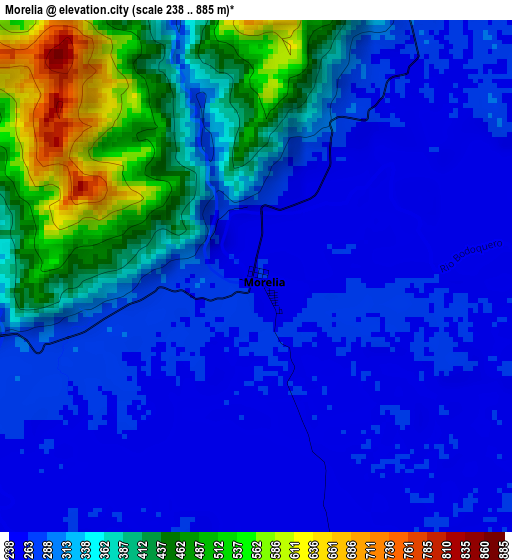
Below is the Elevation map of Morelia, which displays elevation range with different colors. Scale of the first map is from 238 to 885 m (781 to 2904 ft) with average elevation of 329.3 meters (=1080 ft) [note 1]
These maps also provides idea of topography and contour of this city, they are displayed at different zoom levels. More info about maps, scale and edge coordinates you can find below images.
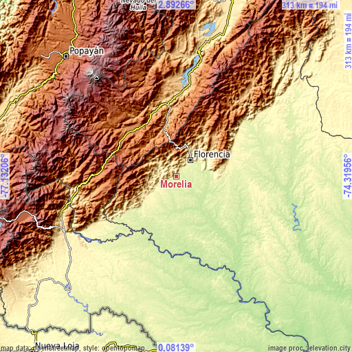
| \ | Map #1 | Topo.Map |
| Scale [m] | 238..885 m | × |
| Scale [ft] | 781..2904 ft | × |
| Average | 329.3 m = 1080 ft | × |
| Width | 9.77 km = 6.1 mi | 312.6 km = 194.2 mi |
| Height | 9.77 km = 6.1 mi | 312.6 km = 194.2 mi |
| ↑Max Latitude | 1.5314° | 2.89266° |
| Latitude at center | 1.48747° | 1.48747° |
| ↓Min Latitude | 1.443539° | 0.08139° |
| ← Min Longitude | -75.769755° | -77.13206° |
| Longitude center | -75.72581° | -75.72581° |
| →Max Longitude | -75.681865° | -74.31956° |
Nearby cities:
Cities around Morelia sort by population:
• Florencia elevation 270 m
19.4 km,  43°
43°
• Pitalito 1265 m
54.4 km,  318°
318°
• El Doncello 357 m
53.4 km,  66°
66°
• El Paujíl 343 m
45.1 km,  78°
78°
• Acevedo 1417 m
39.7 km,  332°
332°
• Albania 277 m
24.5 km,  223°
223°
• Belén de los Andaquíes 330 m
18.5 km,  245°
245°
• Valparaíso 486 m
32.7 km,  176°
176°
• La Montañita 492 m
32.2 km,  91°
91°
• Milán 443 m
32.7 km,  132°
132°
• Palestina 1546 m
52.4 km,  300°
300°
• San José del Fragua 587 m
32.6 km,  237°
237°
Multilingual:
 En español:
Morelia elevación 263 m.
 En France:
Morelia élévation 263 m.


Sources and notes:
- [note 1] Map square and city borders are not equal. Map elevation data is calculated only from area inside that square.
- [src 1] Elevation data from geonames database provided with same terms of usage.
- [src 2] The elevation map of Morelia is generated using elevation data from NASA's 3 arcsec (90m) resolution SRTM data.
- [src 3] Base (background) map © OpenStreetMap contributors tiles are generated by Geofabrik and OpenTopoMap.
Copyright & License:
This Morelia Elevation Map is licensed under CC BY-SA. You may reuse any part from this page, if you give a proper credit by linking to this URL:
 More info on terms of use page.