La Plata elevation
La Plata (Huila), Colombia elevation is 1020 meters and La Plata elevation in feet is 3346 ft above sea level [src 1]. La Plata is a seat of a second-order administrative division (feature code) with elevation that is 129 meters (423 ft) smaller than average city elevation in Colombia.
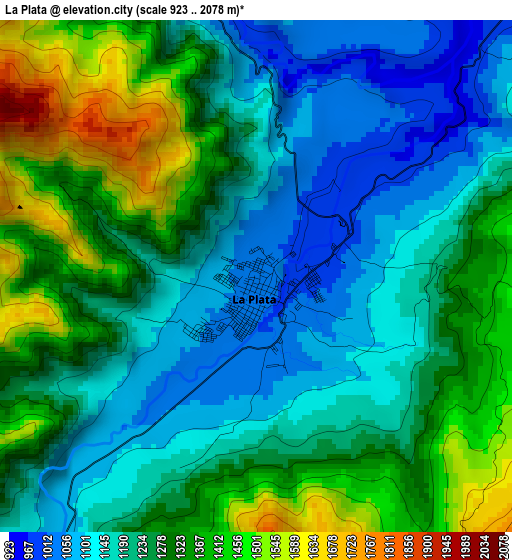
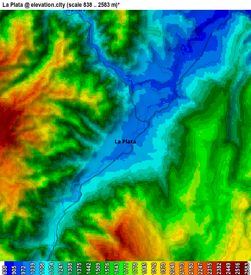
Below is the Elevation map of La Plata, which displays elevation range with different colors. Scale of the first map is from 923 to 2078 m (3028 to 6818 ft) with average elevation of 1256.8 meters (=4123 ft) [note 1]
These maps also provides idea of topography and contour of this city, they are displayed at different zoom levels. More info about maps, scale and edge coordinates you can find below images.
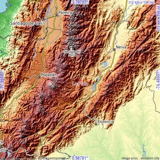
| \ | Map #1 | Map #2 | Topo.Map |
| Scale [m] | 923..2078 m | 838..2583 m | × |
| Scale [ft] | 3028..6818 ft | 2749..8474 ft | × |
| Average | 1256.8 m = 4123 ft | 1494.8 m = 4904 ft | × |
| Width | 9.76 km = 6.1 mi | 19.53 km = 12.1 mi | 312.4 km = 194.1 mi |
| Height | 9.76 km = 6.1 mi | 19.53 km = 12.1 mi | 312.4 km = 194.1 mi |
| ↑Max Latitude | 2.437316° | 2.481221° | 3.79757° |
| Latitude at center | 2.39341° | 2.39341° | 2.39341° |
| ↓Min Latitude | 2.349502° | 2.305593° | 0.98781° |
| ← Min Longitude | -75.936265° | -75.980211° | -77.29857° |
| Longitude center | -75.89232° | -75.89232° | -75.89232° |
| →Max Longitude | -75.848375° | -75.804429° | -74.48607° |
Nearby cities:
Cities around La Plata sort by population:
• Belalcázar elevation 1943 m
29.5 km,  342°
342°
• Garzón 834 m
36.7 km,  126°
126°
• Gigante 808 m
38.3 km,  91°
91°
• La Argentina 1541 m
23.8 km,  204°
204°
• Agrado 844 m
20.2 km,  138°
138°
• Tarqui 827 m
32.1 km,  166°
166°
• Tesalia 830 m
20.8 km,  60°
60°
• Pital 922 m
17.2 km,  145°
145°
• Inzá 1712 m
26.4 km,  312°
312°
• Nátaga 1472 m
19.1 km,  29°
29°
• Altamira 1039 m
38.6 km,  162°
162°
• Paicol 871 m
14.5 km, 64°
Multilingual:
 En español:
La Plata elevación 1020 m.
 En France:
La Plata élévation 1020 m.
 Auf Deutsch:
La Plata höhe über dem Meeresspiegel ist 1020 m.

Sources and notes:
- [note 1] Map square and city borders are not equal. Map elevation data is calculated only from area inside that square.
- [src 1] Elevation data from geonames database provided with same terms of usage.
- [src 2] The elevation map of La Plata is generated using elevation data from NASA's 3 arcsec (90m) resolution SRTM data.
- [src 3] Base (background) map © OpenStreetMap contributors tiles are generated by Geofabrik and OpenTopoMap.
Copyright & License:
This La Plata Elevation Map is licensed under CC BY-SA. You may reuse any part from this page, if you give a proper credit by linking to this URL:
 More info on terms of use page.