La Argentina elevation
La Argentina (Huila), Colombia elevation is 1541 meters and La Argentina elevation in feet is 5056 ft above sea level [src 1]. La Argentina is a seat of a second-order administrative division (feature code) with elevation that is 392 meters (1286 ft) bigger than average city elevation in Colombia.
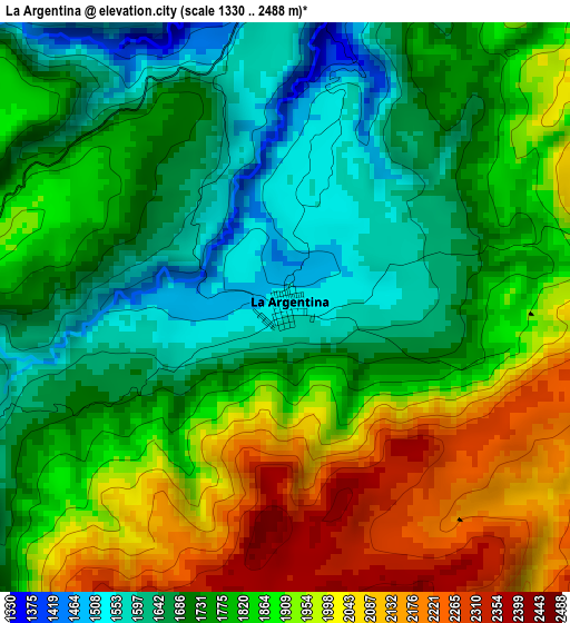
Below is the Elevation map of La Argentina, which displays elevation range with different colors. Scale of the first map is from 1330 to 2488 m (4364 to 8163 ft) with average elevation of 1822.2 meters (=5978 ft) [note 1]
These maps also provides idea of topography and contour of this city, they are displayed at different zoom levels. More info about maps, scale and edge coordinates you can find below images.
| \ | Map #1 | Map #2 | Topo.Map |
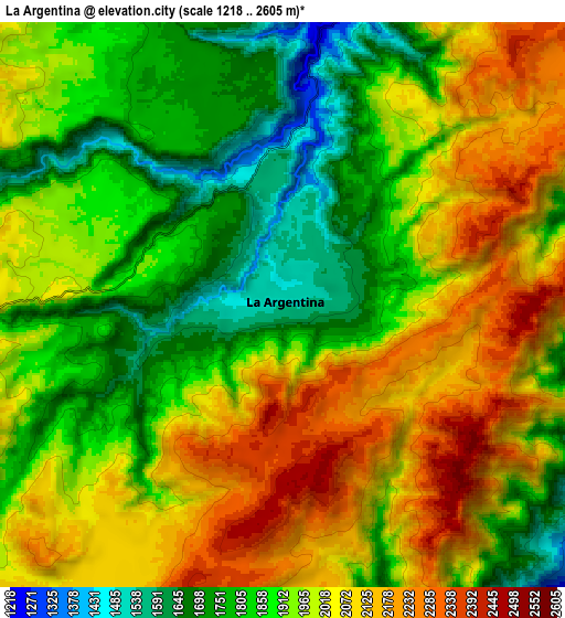
| Scale [m] | 1330..2488 m | 1218..2605 m | × |
| Scale [ft] | 4364..8163 ft | 3996..8547 ft | × |
| Average | 1822.2 m = 5978 ft | 1951.8 m = 6404 ft | × |
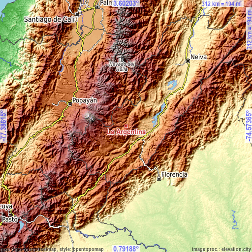
| Width | 9.77 km = 6.1 mi | 19.53 km = 12.1 mi | 312.5 km = 194.2 mi |
| Height | 9.77 km = 6.1 mi | 19.53 km = 12.1 mi | 312.5 km = 194.2 mi |
| ↑Max Latitude | 2.241532° | 2.285443° | 3.60203° |
| Latitude at center | 2.19762° | 2.19762° | 2.19762° |
| ↓Min Latitude | 2.153706° | 2.109791° | 0.79188° |
| ← Min Longitude | -76.023845° | -76.067791° | -77.38615° |
| Longitude center | -75.9799° | -75.9799° | -75.9799° |
| →Max Longitude | -75.935955° | -75.892009° | -74.57365° |
Nearby cities:
Cities around La Argentina sort by population:
• La Plata elevation 1020 m
23.8 km,  24°
24°
• Timaná 1030 m
25.7 km,  167°
167°
• Guadalupe 889 m
31.4 km,  127°
127°
• Agrado 844 m
24.1 km,  74°
74°
• Tarqui 827 m
19.7 km,  118°
118°
• Pital 922 m
20.9 km, 68°
• Suaza 944 m
32.1 km,  140°
140°
• Oporapa 1120 m
19.4 km,  185°
185°
• Altamira 1039 m
26.1 km, 125°
• Paicol 871 m
36.1 km,  39°
39°
• Saladoblanco 1489 m
23.9 km,  197°
197°
• Elías 1292 m
21.1 km, 167°
Multilingual:
 En español:
La Argentina elevación 1541 m.
 En France:
La Argentina élévation 1541 m.
 Auf Deutsch:
La Argentina höhe über dem Meeresspiegel ist 1541 m.

Sources and notes:
- [note 1] Map square and city borders are not equal. Map elevation data is calculated only from area inside that square.
- [src 1] Elevation data from geonames database provided with same terms of usage.
- [src 2] The elevation map of La Argentina is generated using elevation data from NASA's 3 arcsec (90m) resolution SRTM data.
- [src 3] Base (background) map © OpenStreetMap contributors tiles are generated by Geofabrik and OpenTopoMap.
Copyright & License:
This La Argentina Elevation Map is licensed under CC BY-SA. You may reuse any part from this page, if you give a proper credit by linking to this URL:
 More info on terms of use page.