Pital elevation
Pital (Huila), Colombia elevation is 922 meters and Pital elevation in feet is 3025 ft above sea level [src 1]. Pital is a seat of a second-order administrative division (feature code) with elevation that is 227 meters (745 ft) smaller than average city elevation in Colombia.
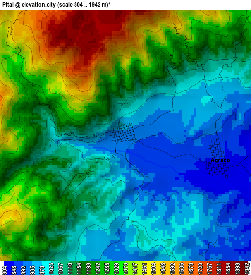
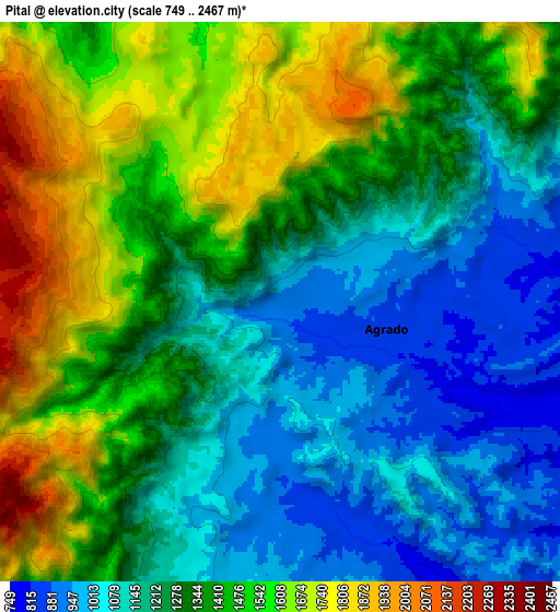
Below is the Elevation map of Pital, which displays elevation range with different colors. Scale of the first map is from 804 to 1942 m (2638 to 6371 ft) with average elevation of 1165.4 meters (=3823 ft) [note 1]
These maps also provides idea of topography and contour of this city, they are displayed at different zoom levels. More info about maps, scale and edge coordinates you can find below images.
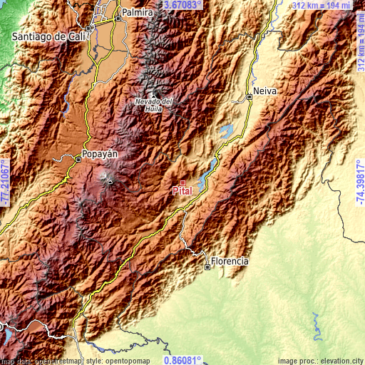
| \ | Map #1 | Map #2 | Topo.Map |
| Scale [m] | 804..1942 m | 749..2467 m | × |
| Scale [ft] | 2638..6371 ft | 2457..8094 ft | × |
| Average | 1165.4 m = 3823 ft | 1336.3 m = 4384 ft | × |
| Width | 9.76 km = 6.1 mi | 19.53 km = 12.1 mi | 312.4 km = 194.1 mi |
| Height | 9.76 km = 6.1 mi | 19.53 km = 12.1 mi | 312.5 km = 194.2 mi |
| ↑Max Latitude | 2.31041° | 2.354319° | 3.67083° |
| Latitude at center | 2.2665° | 2.2665° | 2.2665° |
| ↓Min Latitude | 2.222588° | 2.178676° | 0.86081° |
| ← Min Longitude | -75.848365° | -75.892311° | -77.21067° |
| Longitude center | -75.80442° | -75.80442° | -75.80442° |
| →Max Longitude | -75.760475° | -75.716529° | -74.39817° |
Nearby cities:
Cities around Pital sort by population:
• Garzón elevation 834 m
21.1 km,  111°
111°
• La Plata 1020 m
17.2 km,  325°
325°
• Gigante 808 m
31.5 km,  64°
64°
• La Argentina 1541 m
20.9 km,  248°
248°
• Guadalupe 889 m
27.4 km,  168°
168°
• Agrado 844 m
3.8 km, 105°
• Tarqui 827 m
17.3 km,  187°
187°
• Tesalia 830 m
25.8 km,  18°
18°
• Nátaga 1472 m
30.8 km,  359°
359°
• Altamira 1039 m
22.7 km,  175°
175°
• Paicol 871 m
20.6 km,  9°
9°
• Elías 1292 m
32.1 km,  207°
207°
Multilingual:
 En español:
Pital elevación 922 m.
 En France:
Pital élévation 922 m.


Sources and notes:
- [note 1] Map square and city borders are not equal. Map elevation data is calculated only from area inside that square.
- [src 1] Elevation data from geonames database provided with same terms of usage.
- [src 2] The elevation map of Pital is generated using elevation data from NASA's 3 arcsec (90m) resolution SRTM data.
- [src 3] Base (background) map © OpenStreetMap contributors tiles are generated by Geofabrik and OpenTopoMap.
Copyright & License:
This Pital Elevation Map is licensed under CC BY-SA. You may reuse any part from this page, if you give a proper credit by linking to this URL:
 More info on terms of use page.