Belalcázar elevation
Belalcázar (Cauca, Paez), Colombia elevation is 1943 meters and Belalcázar elevation in feet is 6375 ft above sea level [src 1]. Belalcázar is a seat of a second-order administrative division (feature code) with elevation that is 794 meters (2605 ft) bigger than average city elevation in Colombia.
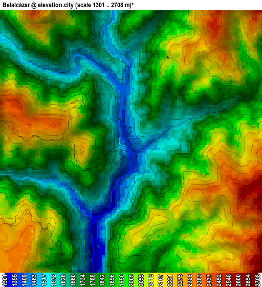
Below is the Elevation map of Belalcázar, which displays elevation range with different colors. Scale of the first map is from 1301 to 2708 m (4268 to 8885 ft) with average elevation of 1918 meters (=6293 ft) [note 1]
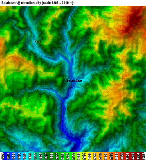
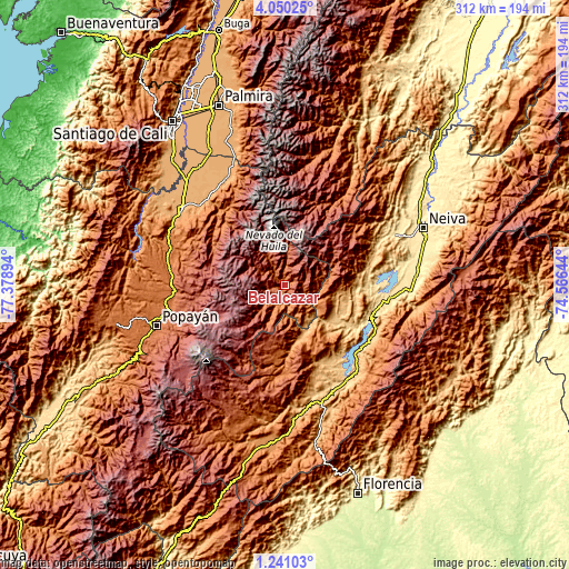
These maps also provides idea of topography and contour of this city, they are displayed at different zoom levels. More info about maps, scale and edge coordinates you can find below images.
| \ | Map #1 | Map #2 | Topo.Map |
| Scale [m] | 1301..2708 m | 1206..3419 m | × |
| Scale [ft] | 4268..8885 ft | 3957..11217 ft | × |
| Average | 1918 m = 6293 ft | 2075.8 m = 6810 ft | × |
| Width | 9.76 km = 6.1 mi | 19.52 km = 12.1 mi | 312.4 km = 194.1 mi |
| Height | 9.76 km = 6.1 mi | 19.52 km = 12.1 mi | 312.4 km = 194.1 mi |
| ↑Max Latitude | 2.690338° | 2.734234° | 4.05025° |
| Latitude at center | 2.64644° | 2.64644° | 2.64644° |
| ↓Min Latitude | 2.602541° | 2.55864° | 1.24103° |
| ← Min Longitude | -76.016635° | -76.060581° | -77.37894° |
| Longitude center | -75.97269° | -75.97269° | -75.97269° |
| →Max Longitude | -75.928745° | -75.884799° | -74.56644° |
Nearby cities:
Cities around Belalcázar sort by population:
• La Plata elevation 1020 m
29.5 km,  162°
162°
• Silvia 2532 m
45.7 km,  265°
265°
• Agrado 844 m
48.7 km,  152°
152°
• Tesalia 830 m
32.4 km,  123°
123°
• Pital 922 m
46.2 km, 156°
• Íquira 1106 m
37.6 km,  89°
89°
• Teruel 875 m
46.3 km,  76°
76°
• Toribío 1700 m
47.5 km,  316°
316°
• Inzá 1712 m
14.7 km,  225°
225°
• Nátaga 1472 m
21.5 km, 122°
• Jambaló 2597 m
41.7 km,  290°
290°
• Paicol 871 m
31 km,  134°
134°
Multilingual:
 En español:
Páez, Belalcázer, Belalcázar, Paez elevación 1943 m.
 En France:
Belalcázar élévation 1943 m.
 Auf Deutsch:
Belalcázar höhe über dem Meeresspiegel ist 1943 m.

Sources and notes:
- [note 1] Map square and city borders are not equal. Map elevation data is calculated only from area inside that square.
- [src 1] Elevation data from geonames database provided with same terms of usage.
- [src 2] The elevation map of Belalcázar is generated using elevation data from NASA's 3 arcsec (90m) resolution SRTM data.
- [src 3] Base (background) map © OpenStreetMap contributors tiles are generated by Geofabrik and OpenTopoMap.
Copyright & License:
This Belalcázar Elevation Map is licensed under CC BY-SA. You may reuse any part from this page, if you give a proper credit by linking to this URL:
 More info on terms of use page.