Silvia elevation
Silvia (Cauca), Colombia elevation is 2532 meters and Silvia elevation in feet is 8307 ft above sea level [src 1]. Silvia is a seat of a second-order administrative division (feature code) with elevation that is 1383 meters (4537 ft) bigger than average city elevation in Colombia.
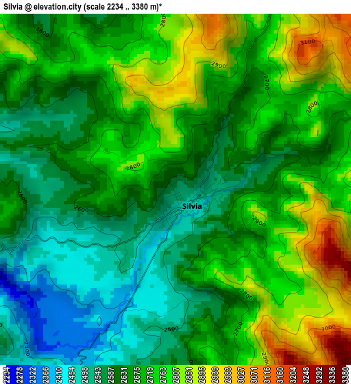
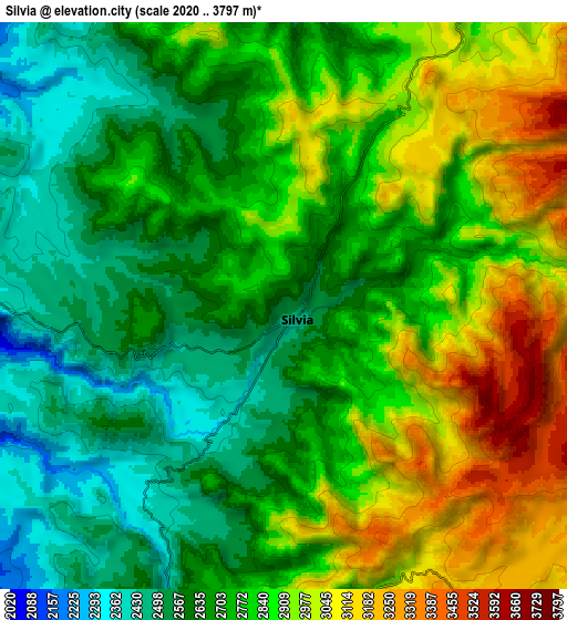
Below is the Elevation map of Silvia, which displays elevation range with different colors. Scale of the first map is from 2234 to 3380 m (7329 to 11089 ft) with average elevation of 2679.5 meters (=8791 ft) [note 1]
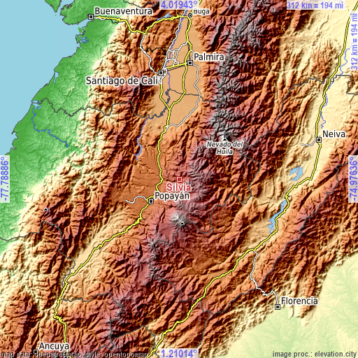
These maps also provides idea of topography and contour of this city, they are displayed at different zoom levels. More info about maps, scale and edge coordinates you can find below images.
| \ | Map #1 | Map #2 | Topo.Map |
| Scale [m] | 2234..3380 m | 2020..3797 m | × |
| Scale [ft] | 7329..11089 ft | 6627..12457 ft | × |
| Average | 2679.5 m = 8791 ft | 2779.5 m = 9119 ft | × |
| Width | 9.76 km = 6.1 mi | 19.52 km = 12.1 mi | 312.4 km = 194.1 mi |
| Height | 9.76 km = 6.1 mi | 19.52 km = 12.1 mi | 312.4 km = 194.1 mi |
| ↑Max Latitude | 2.659469° | 2.703366° | 4.01943° |
| Latitude at center | 2.61557° | 2.61557° | 2.61557° |
| ↓Min Latitude | 2.57167° | 2.527768° | 1.21014° |
| ← Min Longitude | -76.426555° | -76.470501° | -77.78886° |
| Longitude center | -76.38261° | -76.38261° | -76.38261° |
| →Max Longitude | -76.338665° | -76.294719° | -74.97636° |
Nearby cities:
Cities around Silvia sort by population:
• Popayán elevation 1725 m
32.3 km,  232°
232°
• Piendamo 1868 m
16.6 km,  279°
279°
• Santander de Quilichao 1062 m
45.2 km,  345°
345°
• Morales 1814 m
31.3 km,  299°
299°
• Toribío 1700 m
39.8 km,  18°
18°
• Caldono 1704 m
23.1 km,  331°
331°
• Cajibío 1826 m
20.9 km,  272°
272°
• Inzá 1712 m
35.7 km,  100°
100°
• Jambaló 2597 m
19.1 km, 19°
• Totoró 2839 m
11.8 km,  190°
190°
• Timbío 1790 m
44.6 km, 228°
• Coconuco 2406 m
32.9 km,  202°
202°
Multilingual:
 En español:
Silvia elevación 2532 m.
 En France:
Silvia élévation 2532 m.


Sources and notes:
- [note 1] Map square and city borders are not equal. Map elevation data is calculated only from area inside that square.
- [src 1] Elevation data from geonames database provided with same terms of usage.
- [src 2] The elevation map of Silvia is generated using elevation data from NASA's 3 arcsec (90m) resolution SRTM data.
- [src 3] Base (background) map © OpenStreetMap contributors tiles are generated by Geofabrik and OpenTopoMap.
Copyright & License:
This Silvia Elevation Map is licensed under CC BY-SA. You may reuse any part from this page, if you give a proper credit by linking to this URL:
 More info on terms of use page.