Popayán elevation
Popayán (Cauca), Colombia elevation is 1725 meters and Popayán elevation in feet is 5659 ft above sea level [src 1]. Popayán is a seat of a first-order administrative division (feature code) with elevation that is 576 meters (1890 ft) bigger than average city elevation in Colombia.
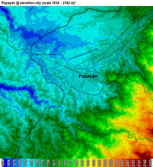
Below is the Elevation map of Popayán, which displays elevation range with different colors. Scale of the first map is from 1634 to 2162 m (5361 to 7093 ft) with average elevation of 1784.9 meters (=5856 ft) [note 1]
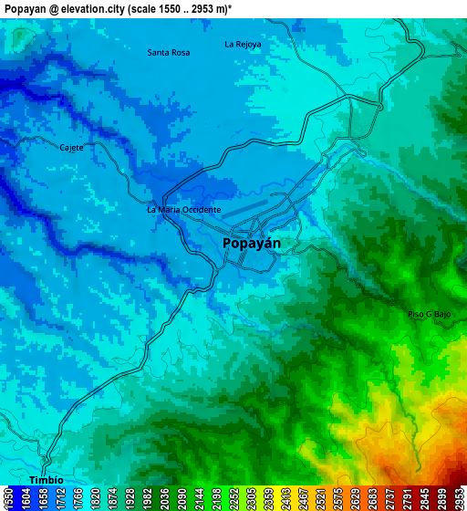
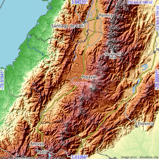
These maps also provides idea of topography and contour of this city, they are displayed at different zoom levels. More info about maps, scale and edge coordinates you can find below images.
| \ | Map #1 | Map #2 | Topo.Map |
| Scale [m] | 1634..2162 m | 1550..2953 m | × |
| Scale [ft] | 5361..7093 ft | 5085..9688 ft | × |
| Average | 1784.9 m = 5856 ft | 1873.6 m = 6147 ft | × |
| Width | 9.76 km = 6.1 mi | 19.53 km = 12.1 mi | 312.4 km = 194.1 mi |
| Height | 9.76 km = 6.1 mi | 19.53 km = 12.1 mi | 312.4 km = 194.1 mi |
| ↑Max Latitude | 2.482135° | 2.526038° | 3.84233° |
| Latitude at center | 2.43823° | 2.43823° | 2.43823° |
| ↓Min Latitude | 2.394324° | 2.350416° | 1.03266° |
| ← Min Longitude | -76.657105° | -76.701051° | -78.01941° |
| Longitude center | -76.61316° | -76.61316° | -76.61316° |
| →Max Longitude | -76.569215° | -76.525269° | -75.20691° |
Nearby cities:
Cities around Popayán sort by population:
• Piendamo elevation 1868 m
24.2 km,  22°
22°
• Villa Rica 1737 m
27.6 km,  287°
287°
• Silvia 2532 m
32.3 km,  52°
52°
• El Tambo 1719 m
22 km,  273°
273°
• López 1791 m
20.8 km, 268°
• Cajibío 1826 m
21.1 km,  13°
13°
• La Sierra 1776 m
33.3 km,  209°
209°
• Totoró 2839 m
24.8 km,  70°
70°
• Rosas 1717 m
24.2 km,  215°
215°
• Paispamba 2531 m
20.4 km,  179°
179°
• Coconuco 2406 m
16.8 km,  129°
129°
• Timbío 1790 m
12.5 km, 218°
Multilingual:
 En español:
Popayán elevación 1725 m.
 En France:
Popayán élévation 1725 m.
 Auf Deutsch:
Popayán höhe über dem Meeresspiegel ist 1725 m.

Sources and notes:
- [note 1] Map square and city borders are not equal. Map elevation data is calculated only from area inside that square.
- [src 1] Elevation data from geonames database provided with same terms of usage.
- [src 2] The elevation map of Popayán is generated using elevation data from NASA's 3 arcsec (90m) resolution SRTM data.
- [src 3] Base (background) map © OpenStreetMap contributors tiles are generated by Geofabrik and OpenTopoMap.
Copyright & License:
This Popayán Elevation Map is licensed under CC BY-SA. You may reuse any part from this page, if you give a proper credit by linking to this URL:
 More info on terms of use page.