Santander de Quilichao elevation
Santander de Quilichao (Cauca), Colombia elevation is 1062 meters and Santander de Quilichao elevation in feet is 3484 ft above sea level [src 1]. Santander de Quilichao is a seat of a second-order administrative division (feature code) with elevation that is 87 meters (285 ft) smaller than average city elevation in Colombia.
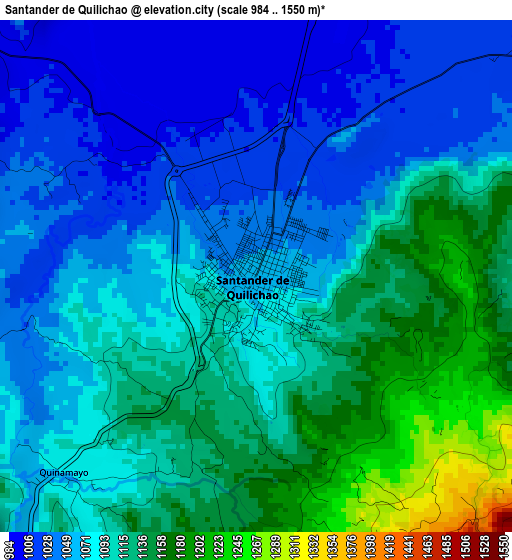
Below is the Elevation map of Santander de Quilichao, which displays elevation range with different colors. Scale of the first map is from 984 to 1550 m (3228 to 5085 ft) with average elevation of 1090.2 meters (=3577 ft) [note 1]
These maps also provides idea of topography and contour of this city, they are displayed at different zoom levels. More info about maps, scale and edge coordinates you can find below images.
| \ | Map #1 | Map #2 | Topo.Map |
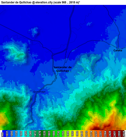
| Scale [m] | 984..1550 m | 968..2618 m | × |
| Scale [ft] | 3228..5085 ft | 3176..8589 ft | × |
| Average | 1090.2 m = 3577 ft | 1201.6 m = 3942 ft | × |
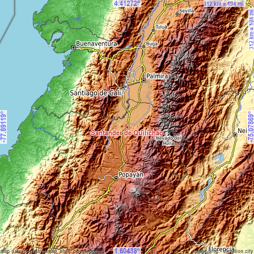
| Width | 9.76 km = 6.1 mi | 19.52 km = 12.1 mi | 312.3 km = 194.1 mi |
| Height | 9.76 km = 6.1 mi | 19.52 km = 12.1 mi | 312.3 km = 194.1 mi |
| ↑Max Latitude | 3.053334° | 3.097216° | 4.41272° |
| Latitude at center | 3.00945° | 3.00945° | 3.00945° |
| ↓Min Latitude | 2.965564° | 2.921677° | 1.60438° |
| ← Min Longitude | -76.528885° | -76.572831° | -77.89119° |
| Longitude center | -76.48494° | -76.48494° | -76.48494° |
| →Max Longitude | -76.440995° | -76.397049° | -75.07869° |
Nearby cities:
Cities around Santander de Quilichao sort by population:
• Puerto Tejada elevation 969 m
25.8 km,  17°
17°
• Jamundí 972 m
28.5 km,  348°
348°
• Corinto 1059 m
30.6 km,  53°
53°
• Suárez 1075 m
24.3 km,  255°
255°
• Caloto 1095 m
9 km,  71°
71°
• Padilla 992 m
30.2 km,  39°
39°
• Toribío 1700 m
24.8 km,  104°
104°
• Caldono 1704 m
23.6 km,  179°
179°
• Buenos Aires 1200 m
17.9 km,  271°
271°
• Jambaló 2597 m
31.3 km,  145°
145°
• Villa Rica 971 m
18.6 km,  7°
7°
• Guachené 997 m
17.2 km, 36°
Multilingual:
 En español:
Santander de Quilichao elevación 1062 m.
 En France:
Santander de Quilichao élévation 1062 m.
 Auf Deutsch:
Santander de Quilichao höhe über dem Meeresspiegel ist 1062 m.
 На русском:
Santander de Quilichao высота над уровнем моря 1062 м
Sources and notes:
- [note 1] Map square and city borders are not equal. Map elevation data is calculated only from area inside that square.
- [src 1] Elevation data from geonames database provided with same terms of usage.
- [src 2] The elevation map of Santander de Quilichao is generated using elevation data from NASA's 3 arcsec (90m) resolution SRTM data.
- [src 3] Base (background) map © OpenStreetMap contributors tiles are generated by Geofabrik and OpenTopoMap.
Copyright & License:
This Santander de Quilichao Elevation Map is licensed under CC BY-SA. You may reuse any part from this page, if you give a proper credit by linking to this URL:
 More info on terms of use page.