Hoxtolgay elevation
Hoxtolgay (Xinjiang), China elevation is 804 meters and Hoxtolgay elevation in feet is 2638 ft above sea level [src 1]. Hoxtolgay is a seat of a fourth-order administrative division (feature code) with elevation that is 246 meters (807 ft) bigger than average city elevation in China.
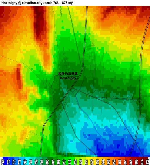
Below is the Elevation map of Hoxtolgay, which displays elevation range with different colors. Scale of the first map is from 766 to 878 m (2513 to 2881 ft) with average elevation of 819 meters (=2687 ft) [note 1]
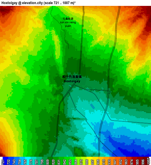
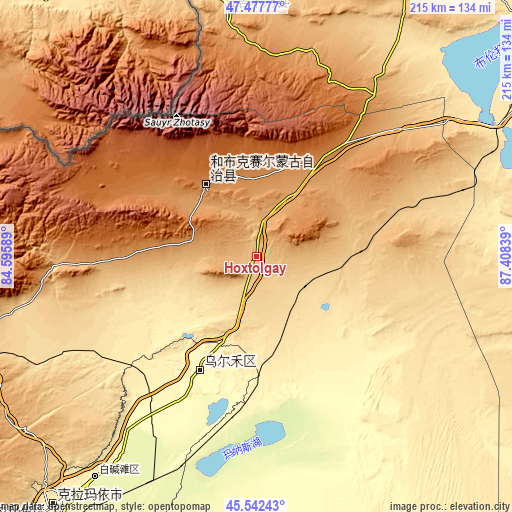
These maps also provides idea of topography and contour of this city, they are displayed at different zoom levels. More info about maps, scale and edge coordinates you can find below images.
| \ | Map #1 | Map #2 | Topo.Map |
| Scale [m] | 766..878 m | 721..1007 m | × |
| Scale [ft] | 2513..2881 ft | 2365..3304 ft | × |
| Average | 819 m = 2687 ft | 844.3 m = 2770 ft | × |
| Width | 6.72 km = 4.2 mi | 13.45 km = 8.4 mi | 215.2 km = 133.7 mi |
| Height | 6.72 km = 4.2 mi | 13.45 km = 8.4 mi | 215.2 km = 133.7 mi |
| ↑Max Latitude | 46.548951° | 46.579165° | 47.47777° |
| Latitude at center | 46.51872° | 46.51872° | 46.51872° |
| ↓Min Latitude | 46.488472° | 46.458207° | 45.54243° |
| ← Min Longitude | 85.958195° | 85.914249° | 84.59589° |
| Longitude center | 86.00214° | 86.00214° | 86.00214° |
| →Max Longitude | 86.046085° | 86.090031° | 87.40839° |
Nearby cities:
Cities around Hoxtolgay sort by population:
• Shihezi elevation 467 m
246.5 km,  179°
179°
• Karamay 366 m
134.9 km,  219°
219°
• Altay 866 m
218.6 km,  47°
47°
• Baijiantan 308 m
113.4 km, 215°
• Khutubi 526 m
267.9 km,  165°
165°
• Dushanzi 721 m
259.1 km,  200°
200°
• Kuytun 478 m
247.9 km, 200°
• Tacheng 546 m
233.7 km,  276°
276°
• Toli 1074 m
195.7 km,  250°
250°
• Emin 522 m
181.2 km,  270°
270°
• Topterek 984 m
102.3 km,  354°
354°
• Urho 308 m
51.2 km,  209°
209°
Multilingual:
 En español:
Hoxtolgay elevación 804 m.
 En France:
Hoxtolgay élévation 804 m.
 Auf Deutsch:
Hoxtolgay höhe über dem Meeresspiegel ist 804 m.

Sources and notes:
- [note 1] Map square and city borders are not equal. Map elevation data is calculated only from area inside that square.
- [src 1] Elevation data from geonames database provided with same terms of usage.
- [src 2] The elevation map of Hoxtolgay is generated using elevation data from NASA's 3 arcsec (90m) resolution SRTM data.
- [src 3] Base (background) map © OpenStreetMap contributors tiles are generated by Geofabrik and OpenTopoMap.
Copyright & License:
This Hoxtolgay Elevation Map is licensed under CC BY-SA. You may reuse any part from this page, if you give a proper credit by linking to this URL:
 More info on terms of use page.