Dushanzi elevation
Dushanzi (Xinjiang, Karamay Shi), China elevation is 721 meters and Dushanzi elevation in feet is 2365 ft above sea level [src 1]. Dushanzi is a seat of a third-order administrative division (feature code) with elevation that is 163 meters (535 ft) bigger than average city elevation in China.
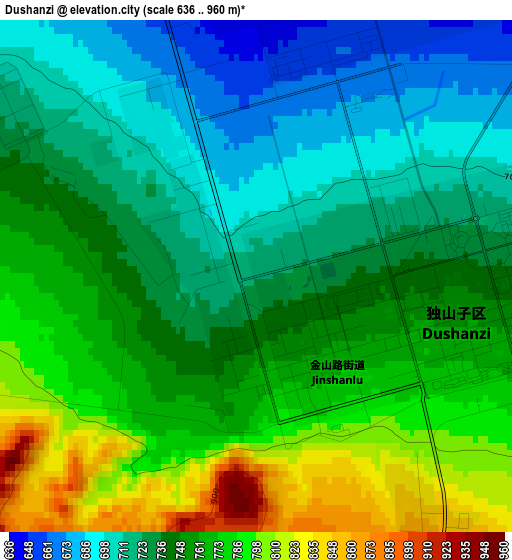
Below is the Elevation map of Dushanzi, which displays elevation range with different colors. Scale of the first map is from 636 to 960 m (2087 to 3150 ft) with average elevation of 747.3 meters (=2452 ft) [note 1]
These maps also provides idea of topography and contour of this city, they are displayed at different zoom levels. More info about maps, scale and edge coordinates you can find below images.
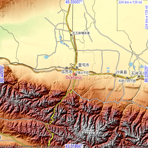
| \ | Map #1 | Topo.Map |
| Scale [m] | 636..960 m | × |
| Scale [ft] | 2087..3150 ft | × |
| Average | 747.3 m = 2452 ft | × |
| Width | 6.99 km = 4.3 mi | 223.7 km = 139 mi |
| Height | 6.99 km = 4.3 mi | 223.7 km = 139 mi |
| ↑Max Latitude | 44.364755° | 45.33057° |
| Latitude at center | 44.33333° | 44.33333° |
| ↓Min Latitude | 44.301888° | 43.31884° |
| ← Min Longitude | 84.806055° | 83.44375° |
| Longitude center | 84.85° | 84.85° |
| →Max Longitude | 84.893945° | 86.25625° |
Nearby cities:
Cities around Dushanzi sort by population:
• Shihezi elevation 467 m
94.5 km,  92°
92°
• Xinyuan 953 m
163.1 km,  231°
231°
• Karamay 366 m
139.2 km,  1°
1°
• Changji 581 m
199.1 km,  100°
100°
• Baijiantan 308 m
152.9 km,  8°
8°
• Baluntaicun 1792 m
220 km,  147°
147°
• Huoche Xizhan 744 m
211.5 km, 104°
• Urho 308 m
208.6 km,  18°
18°
• Toli 1074 m
203.6 km,  331°
331°
• Nilka 1091 m
197.6 km,  252°
252°
• Khutubi 526 m
162.8 km, 95°
• Kuytun 478 m
11.2 km, 21°
Multilingual:
 En español:
Dushanzi elevación 721 m.
 En France:
Dushanzi élévation 721 m.
 Auf Deutsch:
Dushanzi höhe über dem Meeresspiegel ist 721 m.

Sources and notes:
- [note 1] Map square and city borders are not equal. Map elevation data is calculated only from area inside that square.
- [src 1] Elevation data from geonames database provided with same terms of usage.
- [src 2] The elevation map of Dushanzi is generated using elevation data from NASA's 3 arcsec (90m) resolution SRTM data.
- [src 3] Base (background) map © OpenStreetMap contributors tiles are generated by Geofabrik and OpenTopoMap.
Copyright & License:
This Dushanzi Elevation Map is licensed under CC BY-SA. You may reuse any part from this page, if you give a proper credit by linking to this URL:
 More info on terms of use page.