Altay elevation
Altay (Xinjiang), China elevation is 866 meters and Altay elevation in feet is 2841 ft above sea level [src 1]. Altay is a seat of a third-order administrative division (feature code) with elevation that is 308 meters (1010 ft) bigger than average city elevation in China.
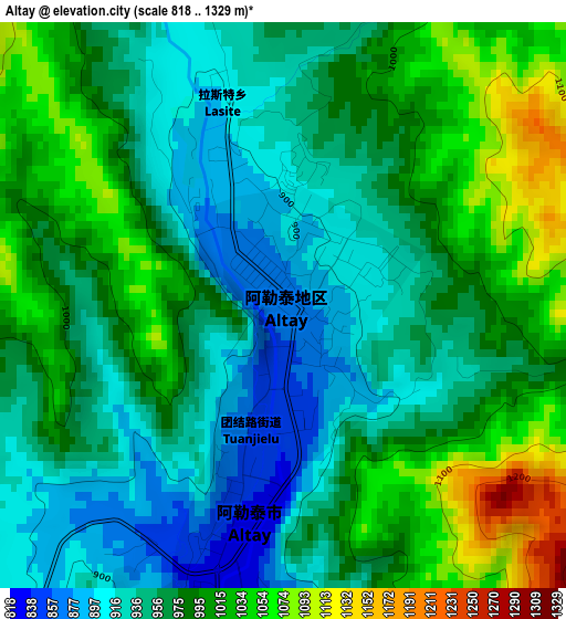
Below is the Elevation map of Altay, which displays elevation range with different colors. Scale of the first map is from 818 to 1329 m (2684 to 4360 ft) with average elevation of 975 meters (=3199 ft) [note 1]
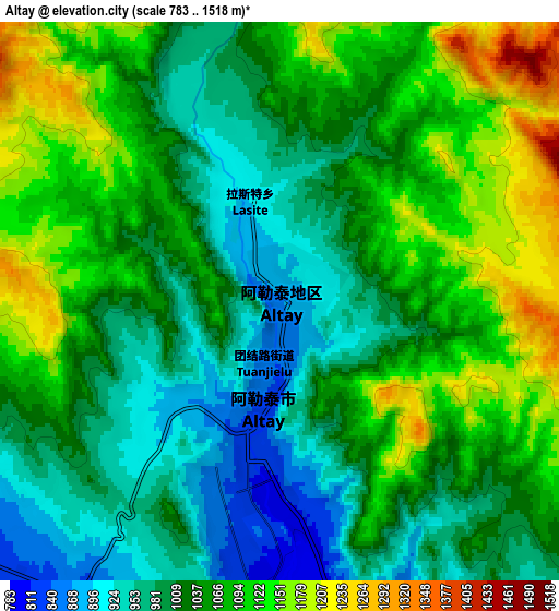
These maps also provides idea of topography and contour of this city, they are displayed at different zoom levels. More info about maps, scale and edge coordinates you can find below images.
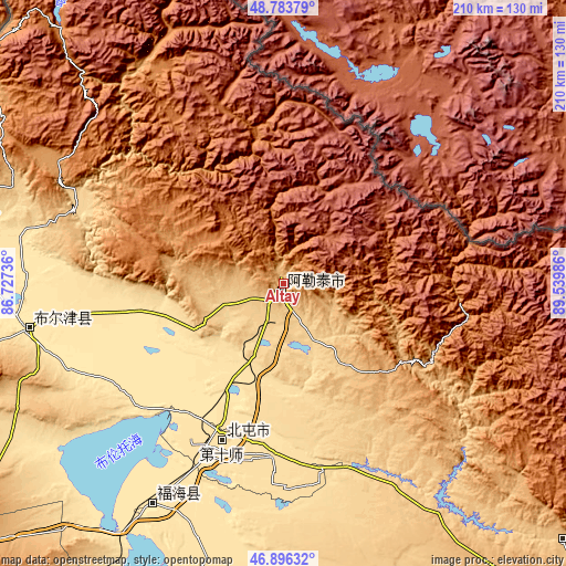
| \ | Map #1 | Map #2 | Topo.Map |
| Scale [m] | 818..1329 m | 783..1518 m | × |
| Scale [ft] | 2684..4360 ft | 2569..4980 ft | × |
| Average | 975 m = 3199 ft | 1042.7 m = 3421 ft | × |
| Width | 6.56 km = 4.1 mi | 13.12 km = 8.2 mi | 209.9 km = 130.4 mi |
| Height | 6.56 km = 4.1 mi | 13.12 km = 8.2 mi | 209.9 km = 130.4 mi |
| ↑Max Latitude | 47.878123° | 47.907589° | 48.78379° |
| Latitude at center | 47.84864° | 47.84864° | 47.84864° |
| ↓Min Latitude | 47.81914° | 47.789624° | 46.89632° |
| ← Min Longitude | 88.089665° | 88.045719° | 86.72736° |
| Longitude center | 88.13361° | 88.13361° | 88.13361° |
| →Max Longitude | 88.177555° | 88.221501° | 89.53986° |
Nearby cities:
Cities around Altay sort by population:
• Karamay elevation 366 m
352.9 km,  224°
224°
• Changji 581 m
431.8 km,  188°
188°
• Baijiantan 308 m
330.8 km, 223°
• Hoxtolgay 804 m
218.6 km,  227°
227°
• Jimsar 786 m
435.8 km,  170°
170°
• Gumudi 633 m
434.4 km,  184°
184°
• Khutubi 526 m
418 km, 193°
• Fukang 550 m
410.5 km, 181°
• Urho 308 m
267.9 km, 224°
• Qinghe 1217 m
214.4 km,  127°
127°
• Topterek 984 m
175.6 km,  254°
254°
Multilingual:
 En español:
Altay elevación 866 m.
 En France:
Altay élévation 866 m.


Sources and notes:
- [note 1] Map square and city borders are not equal. Map elevation data is calculated only from area inside that square.
- [src 1] Elevation data from geonames database provided with same terms of usage.
- [src 2] The elevation map of Altay is generated using elevation data from NASA's 3 arcsec (90m) resolution SRTM data.
- [src 3] Base (background) map © OpenStreetMap contributors tiles are generated by Geofabrik and OpenTopoMap.
Copyright & License:
This Altay Elevation Map is licensed under CC BY-SA. You may reuse any part from this page, if you give a proper credit by linking to this URL:
 More info on terms of use page.