Luzhang elevation
Luzhang (Yunnan), China elevation is 1795 meters and Luzhang elevation in feet is 5889 ft above sea level [src 1]. Luzhang is a seat of a third-order administrative division (feature code) with elevation that is 1237 meters (4058 ft) bigger than average city elevation in China.
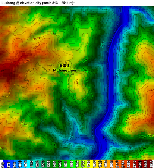
Below is the Elevation map of Luzhang, which displays elevation range with different colors. Scale of the first map is from 813 to 2511 m (2667 to 8238 ft) with average elevation of 1534.5 meters (=5034 ft) [note 1]
These maps also provides idea of topography and contour of this city, they are displayed at different zoom levels. More info about maps, scale and edge coordinates you can find below images.
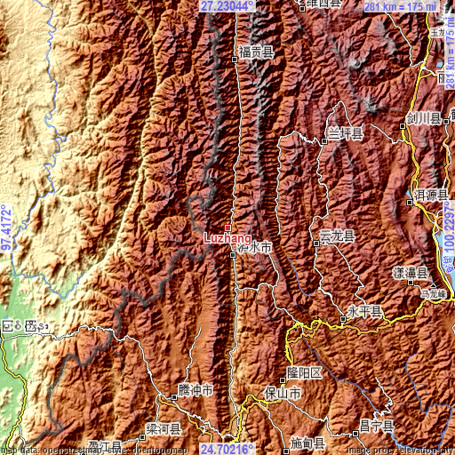
| \ | Map #1 | Topo.Map |
| Scale [m] | 813..2511 m | × |
| Scale [ft] | 2667..8238 ft | × |
| Average | 1534.5 m = 5034 ft | × |
| Width | 8.79 km = 5.5 mi | 281.1 km = 174.7 mi |
| Height | 8.79 km = 5.5 mi | 281.1 km = 174.7 mi |
| ↑Max Latitude | 26.01259° | 27.23044° |
| Latitude at center | 25.97309° | 25.97309° |
| ↓Min Latitude | 25.933577° | 24.70216° |
| ← Min Longitude | 98.779505° | 97.4172° |
| Longitude center | 98.82345° | 98.82345° |
| →Max Longitude | 98.867395° | 100.2297° |
Nearby cities:
Cities around Luzhang sort by population:
• Dali elevation 1977 m
145.6 km,  107°
107°
• Dianyang 1826 m
145.2 km,  166°
166°
• Baohe 2591 m
144.8 km,  20°
20°
• Zhedao 1202 m
139.6 km,  203°
203°
• Jinhua 2201 m
125.9 km,  60°
60°
• Shangjie 1831 m
120.6 km, 106°
• Yuhu 2054 m
116.8 km,  82°
82°
• Tengyue 1639 m
113.1 km, 195°
• Shangpa 2984 m
106 km,  6°
6°
• Laojie 1811 m
93.8 km,  128°
128°
• Jinding 2511 m
80.5 km,  49°
49°
• Shimen 2097 m
61.2 km,  98°
98°
Multilingual:
 En español:
Luzhang elevación 1795 m.
 En France:
Luzhang élévation 1795 m.
 Auf Deutsch:
Luzhang höhe über dem Meeresspiegel ist 1795 m.

Sources and notes:
- [note 1] Map square and city borders are not equal. Map elevation data is calculated only from area inside that square.
- [src 1] Elevation data from geonames database provided with same terms of usage.
- [src 2] The elevation map of Luzhang is generated using elevation data from NASA's 3 arcsec (90m) resolution SRTM data.
- [src 3] Base (background) map © OpenStreetMap contributors tiles are generated by Geofabrik and OpenTopoMap.
Copyright & License:
This Luzhang Elevation Map is licensed under CC BY-SA. You may reuse any part from this page, if you give a proper credit by linking to this URL:
 More info on terms of use page.