Yuhu elevation
Yuhu (Yunnan), China elevation is 2054 meters and Yuhu elevation in feet is 6739 ft above sea level [src 1]. Yuhu is a seat of a third-order administrative division (feature code) with elevation that is 1496 meters (4908 ft) bigger than average city elevation in China.
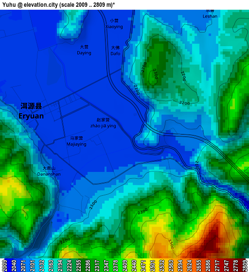
Below is the Elevation map of Yuhu, which displays elevation range with different colors. Scale of the first map is from 2009 to 2809 m (6591 to 9216 ft) with average elevation of 2179.1 meters (=7149 ft) [note 1]
These maps also provides idea of topography and contour of this city, they are displayed at different zoom levels. More info about maps, scale and edge coordinates you can find below images.
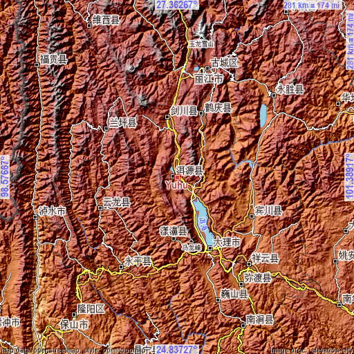
| \ | Map #1 | Topo.Map |
| Scale [m] | 2009..2809 m | × |
| Scale [ft] | 6591..9216 ft | × |
| Average | 2179.1 m = 7149 ft | × |
| Width | 8.78 km = 5.5 mi | 280.8 km = 174.5 mi |
| Height | 8.78 km = 5.5 mi | 280.8 km = 174.5 mi |
| ↑Max Latitude | 26.146245° | 27.36267° |
| Latitude at center | 26.10679° | 26.10679° |
| ↓Min Latitude | 26.067322° | 24.83727° |
| ← Min Longitude | 99.938975° | 98.57667° |
| Longitude center | 99.98292° | 99.98292° |
| →Max Longitude | 100.026865° | 101.38917° |
Nearby cities:
Cities around Yuhu sort by population:
• Lijiang elevation 2397 m
88 km,  15°
15°
• Dali 1977 m
62.4 km,  158°
158°
• Yongbei 2537 m
99.6 km,  52°
52°
• Xiangcheng 1986 m
91.8 km,  140°
140°
• Laojie 1811 m
84.8 km,  210°
210°
• Huangshan 2378 m
83.4 km, 16°
• Jinniu 1444 m
68.2 km,  119°
119°
• Jinding 2511 m
65.5 km,  304°
304°
• Shimen 2097 m
60.1 km,  246°
246°
• Yunhe 2195 m
51.2 km, 24°
• Jinhua 2201 m
48.4 km,  352°
352°
• Shangjie 1831 m
48.4 km,  180°
180°
Multilingual:
 En español:
Yuhu elevación 2054 m.
 En France:
Yuhu élévation 2054 m.


Sources and notes:
- [note 1] Map square and city borders are not equal. Map elevation data is calculated only from area inside that square.
- [src 1] Elevation data from geonames database provided with same terms of usage.
- [src 2] The elevation map of Yuhu is generated using elevation data from NASA's 3 arcsec (90m) resolution SRTM data.
- [src 3] Base (background) map © OpenStreetMap contributors tiles are generated by Geofabrik and OpenTopoMap.
Copyright & License:
This Yuhu Elevation Map is licensed under CC BY-SA. You may reuse any part from this page, if you give a proper credit by linking to this URL:
 More info on terms of use page.