Dali elevation
Dali (Yunnan), China elevation is 1977 meters and Dali elevation in feet is 6486 ft above sea level [src 1]. Dali is a populated place (feature code) with elevation that is 1419 meters (4656 ft) bigger than average city elevation in China.
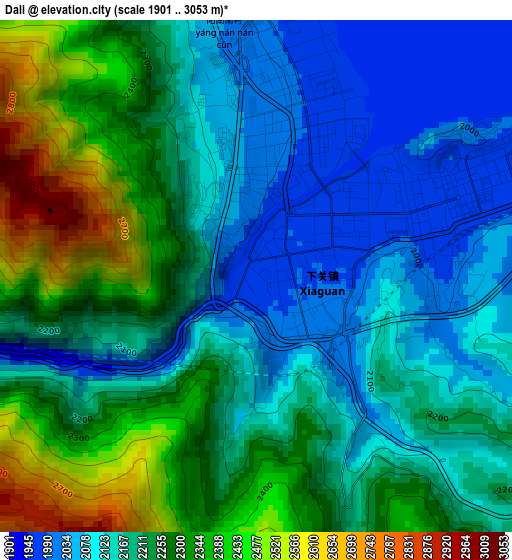
Below is the Elevation map of Dali, which displays elevation range with different colors. Scale of the first map is from 1901 to 3053 m (6237 to 10016 ft) with average elevation of 2214.2 meters (=7264 ft) [note 1]
These maps also provides idea of topography and contour of this city, they are displayed at different zoom levels. More info about maps, scale and edge coordinates you can find below images.
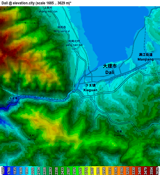
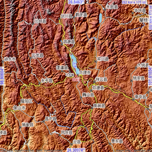
| \ | Map #1 | Map #2 | Topo.Map |
| Scale [m] | 1901..3053 m | 1685..3629 m | × |
| Scale [ft] | 6237..10016 ft | 5528..11906 ft | × |
| Average | 2214.2 m = 7264 ft | 2289.9 m = 7513 ft | × |
| Width | 8.81 km = 5.5 mi | 17.63 km = 11 mi | 282 km = 175.2 mi |
| Height | 8.81 km = 5.5 mi | 17.63 km = 11 mi | 282.1 km = 175.3 mi |
| ↑Max Latitude | 25.62437° | 25.663986° | 26.8463° |
| Latitude at center | 25.58474° | 25.58474° | 25.58474° |
| ↓Min Latitude | 25.545097° | 25.505441° | 24.30974° |
| ← Min Longitude | 100.168345° | 100.124399° | 98.80604° |
| Longitude center | 100.21229° | 100.21229° | 100.21229° |
| →Max Longitude | 100.256235° | 100.300181° | 101.61854° |
Nearby cities:
Cities around Dali sort by population:
• Dongchuan elevation 2146 m
108.3 km,  96°
96°
• Youdian 1822 m
104.7 km,  216°
216°
• Yunhe 2195 m
104.6 km,  359°
359°
• Shimen 2097 m
85.7 km,  293°
293°
• Nanjian 1400 m
67.8 km,  151°
151°
• Laojie 1811 m
67.6 km,  257°
257°
• Yuhu 2054 m
62.4 km,  338°
338°
• Jinniu 1444 m
43.5 km,  56°
56°
• Nanzhao 1713 m
41.3 km,  167°
167°
• Micheng 1662 m
41.2 km,  135°
135°
• Xiangcheng 1986 m
37.5 km,  110°
110°
• Shangjie 1831 m
25.2 km, 292°
Multilingual:
 En español:
Dali elevación 1977 m.
 En France:
Dali élévation 1977 m.


Sources and notes:
- [note 1] Map square and city borders are not equal. Map elevation data is calculated only from area inside that square.
- [src 1] Elevation data from geonames database provided with same terms of usage.
- [src 2] The elevation map of Dali is generated using elevation data from NASA's 3 arcsec (90m) resolution SRTM data.
- [src 3] Base (background) map © OpenStreetMap contributors tiles are generated by Geofabrik and OpenTopoMap.
Copyright & License:
This Dali Elevation Map is licensed under CC BY-SA. You may reuse any part from this page, if you give a proper credit by linking to this URL:
 More info on terms of use page.