Micheng elevation
Micheng (Yunnan), China elevation is 1662 meters and Micheng elevation in feet is 5453 ft above sea level [src 1]. Micheng is a seat of a third-order administrative division (feature code) with elevation that is 1104 meters (3622 ft) bigger than average city elevation in China.
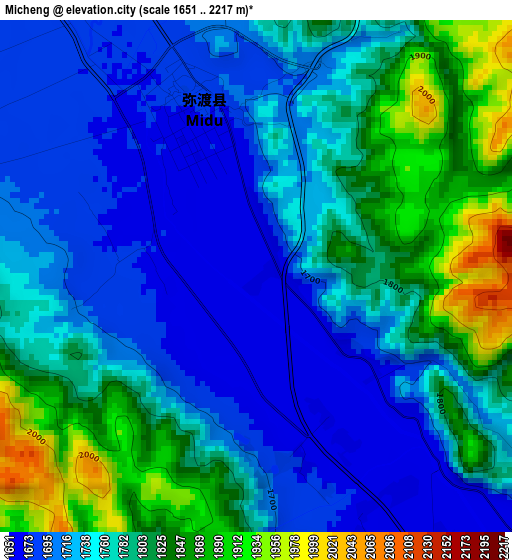
Below is the Elevation map of Micheng, which displays elevation range with different colors. Scale of the first map is from 1651 to 2217 m (5417 to 7274 ft) with average elevation of 1765.3 meters (=5792 ft) [note 1]
These maps also provides idea of topography and contour of this city, they are displayed at different zoom levels. More info about maps, scale and edge coordinates you can find below images.
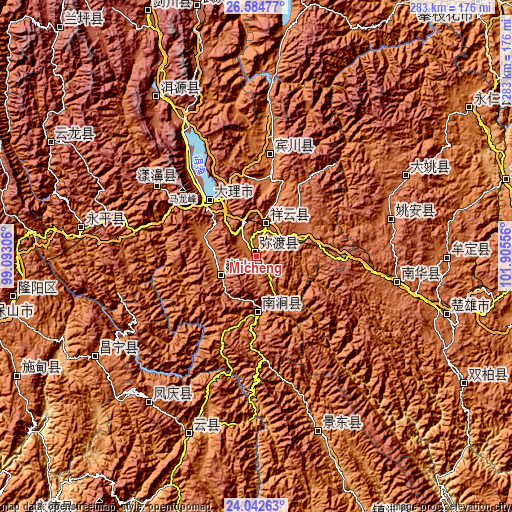
| \ | Map #1 | Topo.Map |
| Scale [m] | 1651..2217 m | × |
| Scale [ft] | 5417..7274 ft | × |
| Average | 1765.3 m = 5792 ft | × |
| Width | 8.83 km = 5.5 mi | 282.7 km = 175.7 mi |
| Height | 8.83 km = 5.5 mi | 282.7 km = 175.7 mi |
| ↑Max Latitude | 25.360087° | 26.58477° |
| Latitude at center | 25.32037° | 25.32037° |
| ↓Min Latitude | 25.28064° | 24.04263° |
| ← Min Longitude | 100.455365° | 99.09306° |
| Longitude center | 100.49931° | 100.49931° |
| →Max Longitude | 100.543255° | 101.90556° |
Nearby cities:
Cities around Micheng sort by population:
• Dali elevation 1977 m
41.2 km,  315°
315°
• Fengshan 1727 m
101.8 km,  216°
216°
• Yuhu 2054 m
101.6 km,  329°
329°
• Laojie 1811 m
95.8 km,  278°
278°
• Jinbi 1859 m
94.5 km,  62°
62°
• Longchuan 1915 m
81.9 km,  102°
102°
• Dongchuan 2146 m
80.8 km,  77°
77°
• Shangjie 1831 m
65.1 km,  306°
306°
• Jinniu 1444 m
53.9 km,  8°
8°
• Nanjian 1400 m
30.5 km,  173°
173°
• Nanzhao 1713 m
22.5 km,  241°
241°
• Xiangcheng 1986 m
17.5 km,  21°
21°
Multilingual:
 En español:
Micheng elevación 1662 m.
 En France:
Micheng élévation 1662 m.
 Auf Deutsch:
Micheng höhe über dem Meeresspiegel ist 1662 m.

Sources and notes:
- [note 1] Map square and city borders are not equal. Map elevation data is calculated only from area inside that square.
- [src 1] Elevation data from geonames database provided with same terms of usage.
- [src 2] The elevation map of Micheng is generated using elevation data from NASA's 3 arcsec (90m) resolution SRTM data.
- [src 3] Base (background) map © OpenStreetMap contributors tiles are generated by Geofabrik and OpenTopoMap.
Copyright & License:
This Micheng Elevation Map is licensed under CC BY-SA. You may reuse any part from this page, if you give a proper credit by linking to this URL:
 More info on terms of use page.