Wenshan City elevation
Wenshan City (Yunnan, Wenshan Zhuangzu Miaozu Zizhizhou), China elevation is 1257 meters and Wenshan City elevation in feet is 4124 ft above sea level [src 1]. Wenshan City is a seat of a second-order administrative division (feature code) with elevation that is 699 meters (2293 ft) bigger than average city elevation in China.
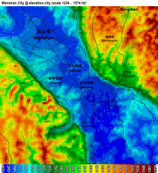
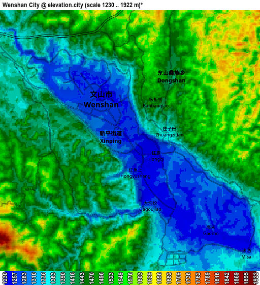
Below is the Elevation map of Wenshan City, which displays elevation range with different colors. Scale of the first map is from 1234 to 1574 m (4049 to 5164 ft) with average elevation of 1354.7 meters (=4445 ft) [note 1]
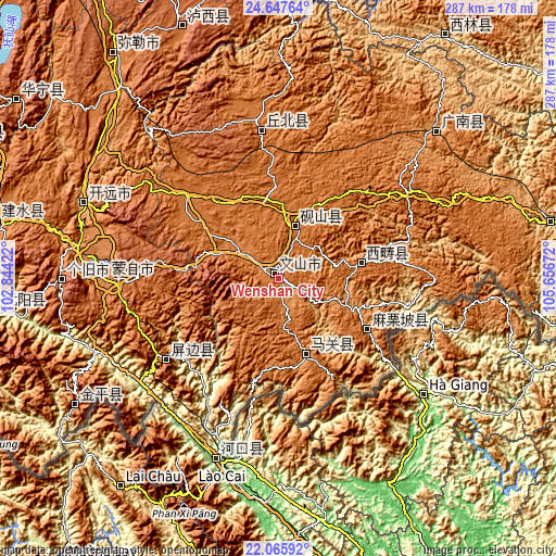
These maps also provides idea of topography and contour of this city, they are displayed at different zoom levels. More info about maps, scale and edge coordinates you can find below images.
| \ | Map #1 | Map #2 | Topo.Map |
| Scale [m] | 1234..1574 m | 1230..1922 m | × |
| Scale [ft] | 4049..5164 ft | 4035..6306 ft | × |
| Average | 1354.7 m = 4445 ft | 1432 m = 4698 ft | × |
| Width | 8.97 km = 5.6 mi | 17.94 km = 11.1 mi | 287.1 km = 178.4 mi |
| Height | 8.97 km = 5.6 mi | 17.94 km = 11.1 mi | 287.1 km = 178.4 mi |
| ↑Max Latitude | 23.403396° | 23.44372° | 24.64764° |
| Latitude at center | 23.36306° | 23.36306° | 23.36306° |
| ↓Min Latitude | 23.322712° | 23.282351° | 22.06592° |
| ← Min Longitude | 104.206525° | 104.162579° | 102.84422° |
| Longitude center | 104.25047° | 104.25047° | 104.25047° |
| →Max Longitude | 104.294415° | 104.338361° | 105.65672° |
Nearby cities:
Cities around Wenshan City sort by population:
• Kaiyuan elevation 1259 m
103.4 km,  291°
291°
• Gejiu 1708 m
111.9 km,  269°
269°
• Kaihua 1371 m
2.8 km,  75°
75°
• Mabai 1501 m
44 km,  152°
152°
• Liancheng 1245 m
113.6 km,  47°
47°
• Hekou 143 m
94.9 km,  194°
194°
• Wenlan 1309 m
83.1 km, 269°
• Jinping 1463 m
74.3 km,  358°
358°
• Yuping 1261 m
69.9 km,  232°
232°
• Mali 1239 m
56.6 km,  117°
117°
• Xisa 1515 m
47.7 km, 78°
• Jiangna 1583 m
30.1 km,  24°
24°
Multilingual:
 En español:
Wenshan City elevación 1257 m.
 En France:
Wenshan City élévation 1257 m.
 Auf Deutsch:
Wenshan City höhe über dem Meeresspiegel ist 1257 m.

Sources and notes:
- [note 1] Map square and city borders are not equal. Map elevation data is calculated only from area inside that square.
- [src 1] Elevation data from geonames database provided with same terms of usage.
- [src 2] The elevation map of Wenshan City is generated using elevation data from NASA's 3 arcsec (90m) resolution SRTM data.
- [src 3] Base (background) map © OpenStreetMap contributors tiles are generated by Geofabrik and OpenTopoMap.
Copyright & License:
This Wenshan City Elevation Map is licensed under CC BY-SA. You may reuse any part from this page, if you give a proper credit by linking to this URL:
 More info on terms of use page.